|
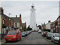
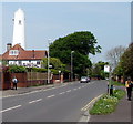
Arthur Street, Withernsea
by Malc McDonald
geograph for square TA3328
Arthur Street is a residential road in Withernsea, on the East Yorkshire coast.... (more)
|
|
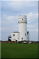
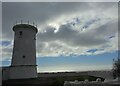
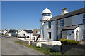
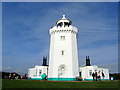
Portland Bill - Old Lower Lighthouse
by Chris Talbot
geograph for square SY6868
This lighthouse was built in 1869, it has not been used as a lighthouse since... (more)
|
|
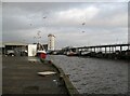
Fishing boats in the Gut
by Adrian Taylor
geograph for square NZ3668
The fish dock at North Shields, Fish Quay is on the right and in the background... (more)
|
|
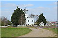
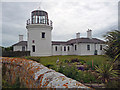
Former West Usk Lighthouse
by M J Roscoe
geograph for square ST3182
Lighthouse built 1821 operational until 1922, now a bed and breakfast... (more)
|
|
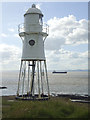
Harwich Low Lighthouse
by Chris Heaton
geograph for square TM2632
Approaching the Low Lighthouse on the Essex Way, passing a row of colourful... (more)
|
|
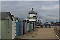
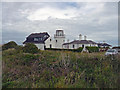
The Lighthouse, Lighthouse Close, Hunstanton
by Ian S
for square TF6742
Former lighthouse now a holiday cottage.
|
|
Old lighthouse seen from the Saxon Shore Way
by Marathon
geograph for square TQ6975
This is the view on the Saxon Shore Way, just after passing Shornmead Fort on... (more)
|
|
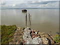
Remains of the jetty to an old lighthouse on Higham Saltings
by Marathon
geograph for square TQ6975
This is the view on the Saxon Shore Way, just after passing Shornmead Fort on... (more)
|
|
Remains of the jetty to an old lighthouse on Higham Saltings
by Marathon
geograph for square TQ6975
This is the view on the Saxon Shore Way, just after passing Shornmead Fort on... (more)
|
|
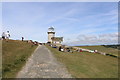
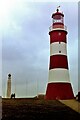
Portland Bill - The Old Higher Lighthouse
by Chris Talbot
geograph for square SY6769
This lighthouse was constructed circa 1869, and one time home of Mary Stopes,... (more)
|
|
Portland Bill - The Old Higher Lighthouse
by Chris Talbot
geograph for square SY6769
This lighthouse was constructed circa 1869, and one time home of Mary Stopes,... (more)
|
|
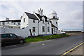
West Usk Lighthouse bed & breakfast establishment
by M J Roscoe
geograph for square ST3182
|
|
Walkers near Grade II listed High Lighthouse, Burnham-on-Sea
by Jaggery
geograph for square ST3050
Viewed across Berrow Road. The Burnham-on-Sea website states that Burnham's... (more)
|
|
Lower (West) Lighthouse at Nash Point, St Donats
by Colin Cheesman
geograph for square SS9168
Built as an ambitious pair of lighthouses to assist navigation in the Bristol... (more)
|
|
Harwich High Lighthouse
by Chris Heaton
geograph for square TM2632
The Essex Way crosses Harwich Green to reach the High Lighthouse from the Low... (more)
|
|
Grade II listed High Lighthouse, Burnham-on-Sea
by Jaggery
geograph for square ST3050
Viewed across Berrow Road. The Burnham-on-Sea website states that Burnham's... (more)
|
|
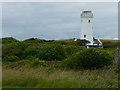
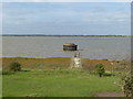
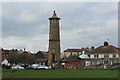
The Old Lighthouse
by Des Blenkinsopp
geograph for square TA1626
The lighthouse was put up by Trinity House and operated between 1836 and 1870.... (more)
|
|
Belle Tout
by Andrew Diack
geograph for square TV5695
The photo shows a view of the former Belle Tout Lighthouse. Most of the people... (more)
|
|
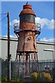
Former lighthouse in corner of Port of London Authority yard, Denton
by David Martin
for square TQ6674
|
|
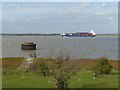
A container ship heads upriver
by Marathon
geograph for square TQ6975
This is the view on the Saxon Shore Way, just after passing Shornmead Fort on... (more)
|

|
Mud and shingle in a bay next to Higham Saltings
by Marathon
geograph for square TQ6975
This is the view on the Saxon Shore Way, just after passing Shornmead Fort on... (more)
|
|
South Foreland Lighthouse
by Chris Heaton
geograph for square TR3543
Sparkling white in the sunshine, the lighthouse is now owned by the National... (more)
|
|
Remaining on station
by Neil Owen
geograph for square ST4476
The cast iron lighthouse at Black Nore was supposed to have been retired and... (more)
|
|
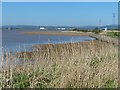
The mouth of the River Usk
by Robin Drayton
geograph for square ST3382
Taken from the Wales Coast Path at Newport Wetlands.
The East Usk lighthouse... (more)
|
|
Smeaton's and a seagull
by Neil Owen
geograph for square SX4753
One tower was a lighthouse protecting the mariners. The other tall object is... (more)
|
|
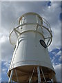
Rivets and cast iron
by Neil Owen
for square ST4476
The Black Nore lighthouse was designed and built in 1894, using cast iron tubes... (more)
|
|
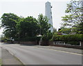
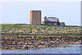
Former Paull Lighthouse
by Ian S
geograph for square TA1626
|
|
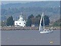
A yacht at the mouth of the River Usk
by Robin Drayton
for square ST3182
About to pass the West Usk Lighthouse which is now a private residence.
Taken... (more)
|
|
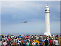
Royal Navy Lynx Helicopter performing at the Sunderland International Airshow
by Graham Robson
for square NZ4059
A Royal Navy Lynx helicopter is performing its display as part of the 25th... (more)
|
|
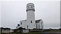
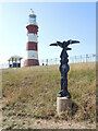
The Lighthouse, Hunstanton
by Sandy Gerrard
geograph for square TF6742
|
|
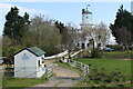
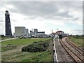
Dungeness RH&DR railway station, Kent
by Nigel Thompson
geograph for square TR0816
Opened in 1928 as "Dungeness Lighthouse", this station is the southern... (more)
|
|
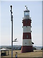
Smeaton's Tower, Plymouth Hoe, 1982
by Nigel Thompson
geograph for square SX4753
Originally built on the Eddystone reef in 1759. Taken down in the early 1880s... (more)
|
|
Port Logan lighthouse
by Ian Taylor
geograph for square NX0940
Historic Environment Scotland attributes the harbour wall design to John Rennie.... (more)
|
|
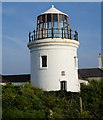
Old Higher Lighthouse, Portland
by Ian S
geograph for square SY6769
|
|
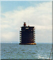
Nab Tower, 1990
by Des Blenkinsopp
geograph for square SZ7485
Apologies for poor quality, but this is a scan from a picture taken on a sailing... (more)
|
|
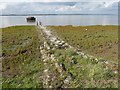
Tower and House on Brownsman Island
by Des Blenkinsopp
geograph for square NU2337
An old beacon tower with a restored cottage next to it which is used by resident... (more)
|
|
National Cycle Route milepost
by Neil Owen
geograph for square SX4753
Close to Smeaton's Tower is a marker for the pedallers. It relates that it... (more)
|