Geograph - photograph every grid square
About tags on Geograph
Tags
Geographical Context
Subjects
Types
Other Prefixes
Public Tags
Related Tags
|
Coverage Map
Prefix:
geographical feature
Tag:
Weir
Other tags:
Weir
category:
Weir
former:
Weir
place:
Weir
ruin:
Weir
subject:
Weir
Showing images tagged with
geographical feature:
Weir
tag.
View all tagged images
-
In Browser
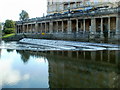
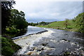
Pulteney Weir, Bath
by
Jaggery
geograph for square
ST7564
The River Avon weir is a few tens of metres downstream from the Grade I listed... (
more
)
Tags:
top:
Rivers, Streams, Drainage
X
geographical feature:
Weir
Weir
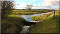
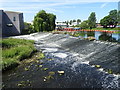
Weir on the Maxey Cut at Nine Bridges
by
Paul Bryan
for square
TF1407
Nine Bridges is a road viaduct on Lincoln Road spanning the Maxey Cut between... (
more
)
Tags:
type:
Cross Grid
X
Drain
X
Drainage
X
Drainage Channel
X
top:
Flat Landscapes
X
top:
Rivers, Streams, Drainage
X
Road Viaduct
X
Viaduct
X
subject:
Weir
Weir
geographical feature:
Weir
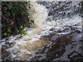
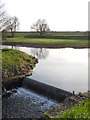
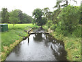
Weir at Lynford Lakes
by
David Pashley
for square
TL8193
Weir between Lynford Lakes in full flow.
Tags:
type:
Close Look
X
top:
Lowlands
X
Lynford Lakes
X
Norfolk
X
top:
Rivers, Streams, Drainage
X
subject:
Weir
geographical feature:
Weir
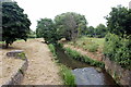
Weir on the Maxey Cut at Nine Bridges
by
Paul Bryan
for square
TF1507
Heavy rainfall in the first few months of 2016 is reflected in the relatively... (
more
)
Tags:
Drainage
X
Drainage Channel
X
top:
Rivers, Streams, Drainage
X
geographical feature:
Weir
Weir
subject:
Weir
Weir on the Maxey Cut at Nine Bridges
by
Paul Bryan
for square
TF1407
Heavy rainfall in the first few months of 2016 is reflected in the relatively... (
more
)
Tags:
type:
Cross Grid
X
Drainage
X
Drainage Channel
X
top:
Flat Landscapes
X
top:
Rivers, Streams, Drainage
X
geographical feature:
Weir
Weir
subject:
Weir
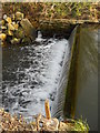
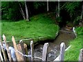
Weir off Wildnerness Lake
by
Ed of the South
geograph for square
TQ3940
A view of a weir in operation, regulating outlet from the Wilderness Lake, Dormans Park.
Tags:
Cooks Pond
X
place:
Dormans Park
X
top:
Lakes, Wetland, Bog
X
top:
Rivers, Streams, Drainage
X
geographical feature:
Weir
Weir in The River Nidd, Knaresborough
by
Richard Humphrey
geograph for square
SE3456
Tags:
type:
Geograph
X
River
X
subject:
River
X
top:
Rivers, Streams, Drainage
X
geographical feature:
Weir
Weir
Woods
X
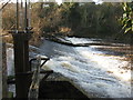
Weir on the River Esk at Musselburgh
by
M J Richardson
geograph for square
NT3371
With the river in good flow after a wet December.
Tags:
place:
East Lothian
X
river:
Esk
X
Musselburgh
X
top:
Rivers, Streams, Drainage
X
top:
Suburb, Urban Fringe
X
geographical feature:
Weir
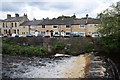
Weir with Gisburn Road, Barrowford (the A682) behind
by
Bill Harrison
geograph for square
SD8639
Tags:
road:
A682
X
type:
Geograph
X
top:
Housing, Dwellings
X
top:
Rivers, Streams, Drainage
X
geographical feature:
Weir
Weirs on the River Wharfe at Linton
by
Bill Harrison
geograph for square
SE0063
Tags:
type:
Geograph
X
top:
Grassland
X
river:
River Wharfe
X
top:
Rivers, Streams, Drainage
X
top:
Uplands
X
geographical feature:
Weir
Weir on the River Calder
by
John M
geograph for square
SE3320
Tags:
type:
Geograph
X
top:
Rivers, Streams, Drainage
X
top:
Suburb, Urban Fringe
X
geographical feature:
Weir
Little Ouse River & Gauging Station
by
Geographer
geograph for square
TL8980
Off the A1088 Thetford Road
Tags:
A1088
X
at:
Euston
X
Gauging Station
X
type:
Geograph
X
Little Ouse River
X
subject:
River
X
top:
Rivers, Streams, Drainage
X
in:
Suffolk
X
off:
The A1088 Thetford Road
X
Thetford Road
X
top:
Village, Rural Settlement
X
geographical feature:
Weir
Weir
Bridport's other river
by
Bill Harrison
geograph for square
SY4792
The modest River Asker (as viewed from the East Bridge of 1784) has its... (
more
)
Tags:
type:
Geograph
X
Mown Grass
X
Reeds
X
top:
Rivers, Streams, Drainage
X
top:
Suburb, Urban Fringe
X
geographical feature:
Weir
View more in the Image Search
or
in Browser
View images matching 'Weir' anywhere
in
the tags
Don't click these:
PotMel 1
PotMel 2
☰
Home
View
Search
Marked Images
Maps
Browser
Explore
Showcase
New Images
Collections
Interact
Games
Discussions
Blog
Contributors
Submit
Statistics
Leaderboards
General
FAQ
Help Pages
Sitemap
Contact Us
Support Us
sponsored by
🔍
What to search:
Photos
Enter keywords or a location/postcode to search nearby images
Enter a Grid Reference
Placenames
Collections
Website Pages
Everything
Others:
Advanced Search
|
Image Browser
Or:
Coverage Map
|
Searchable Map
You are not logged in
login
|
register