Public Tags
Tag: Hanging·Valley
Other tags: subject:Hanging Valley
Showing images tagged with Hanging Valley tag.
|
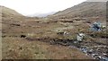
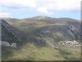
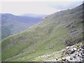
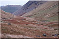
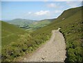
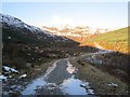
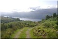
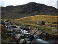
Hanging valley
by Richard Webb geograph for square NN4036 The upper glen of the Allt Bad a' Mhàim is a boggy hanging valley.
|
|
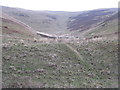
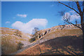
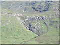
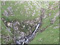
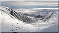
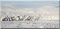
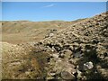
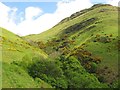
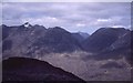
Looking into Dod Slack
by M J Richardson geograph for square NT3342 What looks like a small hanging valley on the side of Dod Hill.
|
|
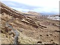
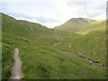
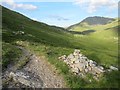
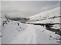
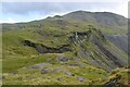
The path from Sticks Pass
by Oliver Dixon geograph for square NY3518 Looking down the hanging valley of the Sticks Gill below Sticks Pass on the way... (more)
|
|
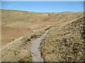
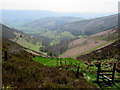
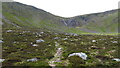
Langdale Combe
by Adrian Taylor geograph for square NY2608 Langdale Combe is a boggy, glaciated, hanging valley at the head of Great... (more)
Tags:
CombeX
long distance path:Cumbria WayX
Cumbria WayX
type:GeographX
near:Great LangdaleX
subject:Hanging Valley
top:Lakes, Wetland, BogX
LangdaleX
Langdale CombeX
top:PathsX
Stake PassX
long distance footpath:The Cumbria WayX
The Cumbria WayX
ldp:The Cumbria WayX
long distance path:The Cumbria WayX
top:UplandsX
|
|
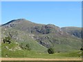
Coire Beinn Dearg
by Richard Webb for square NH2579 Category: Hill The Allt Beinn Dearg cascades over the lip of this hanging valley on Beinn... (more)
Tags:
Hanging Valley
|
|
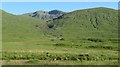
Coire Ghàidheil
by Richard Webb geograph for square NH1021 The lower corrie is a hanging valley with a steep descent to Glen Affric. When... (more)
Tags:
Hanging Valley
top:MoorlandX
|
|
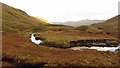
Allt a' Mharcaidh
by Richard Webb geograph for square NH8803 A hanging valley above Inshriach Forest. The headwall is dominated by Sgòran... (more)
|
|
Allt Bad a' Mhàim
by Richard Webb geograph for square NN4035 The burn approaches the lip of its hanging valley.
|
|
Pillar Cove from above
by Richard Law geograph for square NY1712 A hanging valley above Ennerdale, Pillar Cove holds a scattering of boulders and... (more)
Tags:
Hanging Valley
top:UplandsX
|
|
The Scar Gill
by Stephen Craven geograph for square SD9871 Category: Glacial feature The dry glacial hanging valley ('gill') through the limestone outcrop... (more)
|
|
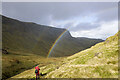
Rainbow over Gillercomb
by Trevor Littlewood geograph for square NY2211 Gillercomb is a hanging valley drained by Sour Milk Gill; it's enclosed by... (more)
Tags:
top:Air, Sky, WeatherX
type:GeographX
Hanging Valley
RainbowX
top:Rivers, Streams, DrainageX
top:Sport, LeisureX
top:UplandsX
|
|
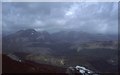
Coire Lair
by Richard Webb for square NG9850 A very rocky and spectacular hanging valley above Strath Carron. It is... (more)
Tags:
top:Barren PlateauxX
p150 hill:Beinn Liath MhorX
type:Cross GridX
p150 hill:Fuar ThollX
top:Geological InterestX
Hanging Valley
top:Rocks, Scree, CliffsX
|

|
Cuilsten Burn
by Richard Webb for square NO3999 A hanging valley north of Ballater with Morven in the background.
|
|
Spùtan Bàn
by Richard Webb for square NH1322 The hanging valley of the Allt Coulavie is above this sharp drop to Glen Affric... (more)
Tags:
BurnX
CragsX
type:Cross GridX
top:Geological InterestX
Hanging Valley
top:Rivers, Streams, DrainageX
top:Rocks, Scree, CliffsX
WaterfallX
|
|
An Tudair
by Richard Webb for square NH1323 A spur off Màm Sodhail which ends abruptly at a truncated spur. This part of... (more)
Tags:
top:Barren PlateauxX
CragsX
type:Cross GridX
top:Geological InterestX
Hanging Valley
top:Rivers, Streams, DrainageX
top:Rocks, Scree, CliffsX
Truncated SpurX
WaterfallX
|
|
Sgùrr nan Ceathreamhnan
by Richard Webb for square NH0620 The Affric side of Ceathreamhnan with the surrounding land around the Allt... (more)
Tags:
BurnX
type:Cross GridX
top:Geological InterestX
Hanging Valley
top:MoorlandX
top:Rivers, Streams, DrainageX
p150 hill:Sgurr Nan CeathreamhnanX
|
|
Kintail to Affric path, Allt Grannda
by Richard Webb geograph for square NH0317 The hanging valley, above the gorge section. If it were not for the wide... (more)
Tags:
long distance path:Affric Kintail WayX
p150 hill:Ciste DhubhX
type:GeographX
Hanging Valley
PassX
top:PathsX
top:Rivers, Streams, DrainageX
|
|
View towards Affric
by Richard Webb geograph for square NH0217 The path up from Gleann Lichd has completed the long stiff gorge climb and the... (more)
Tags:
long distance path:Affric Kintail WayX
p150 hill:Ciste DhubhX
type:GeographX
top:Geological InterestX
Hanging Valley
top:MoorlandX
PassX
top:PathsX
|
|
Fall on the Allt Grannda
by Richard Webb geograph for square NH0217 A fine example of a burn leaving a hanging valley. The Allt Granda has cut a... (more)
Tags:
type:GeographX
top:Geological InterestX
top:GrasslandX
Hanging Valley
top:Rivers, Streams, DrainageX
WaterfallX
|
|
Hanging valley above the Dee
by John H Darch geograph for square SJ1746 |
|
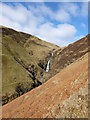
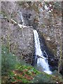
Grey Mare's Tail
by Alan O'Dowd geograph for square NT1814 A famous hanging valley waterfall, a short distance from the Moffat to Selkirk road.
Tags:
top:Geological InterestX
Grey Mares TailX
Grey Mares Tail Nature ReserveX
Hanging Valley
top:Rivers, Streams, DrainageX
top:UplandsX
subject:Weather VaneX
|
|
Above Talla Linnfoots
by Richard Webb geograph for square NT1420 The edge of the Talla hanging valley with the reservoir below. A road sign warns... (more)
|
|
Bridge over the Talla Water
by Richard Webb geograph for square NT1420 The Talla Water on the verge of its plunge from a hanging valley to the lower... (more)
|
|
Allt an Dubh Loch
by Richard Webb for square NO2283 The glen round the back of Lochnagar. The famous crags of Creag an Dubh Loch are... (more)
Tags:
top:Barren PlateauxX
BurnX
CragX
top:Geological InterestX
Hanging Valley
top:Lakes, Wetland, BogX
LochX
top:Rocks, Scree, CliffsX
|
|
The Stank Glen
by Richard Webb geograph for square NN5710 A spur of a Forestry Commission logging road runs up the glen which is a hanging... (more)
Tags:
CragX
Hanging Valley
top:Roads, Road TransportX
top:Rocks, Scree, CliffsX
top:Woodland, ForestX
|
|
Head of the Canness Burn
by Richard Webb for square NO2077 A hanging valley with the Canness Burn flowing towards a plunge into the... (more)
|
|
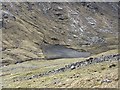
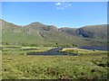
Loch an Easain
by Richard Webb geograph for square NN2549 Near the furthest flung source of the Tay, this lochan sits on the lip of a... (more)
Tags:
top:Geological InterestX
Hanging Valley
top:Lakes, Wetland, BogX
LochanX
top:MoorlandX
top:Rocks, Scree, CliffsX
|
|
Allt Bad a' Mhàim
by Richard Webb geograph for square NN4036 The burn is in a hanging valley which is very boggy,
|
|
Sheep grazing above Gillercomb
by Karl and Ali geograph for square NY2212 Gillercomb is a classic hanging valley perched high above the upper reaches of... (more)
|
|
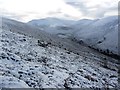
Drumlins in Threshthwaite Cove
by Jim Barton geograph for square NY4210 Several drumlins on the floor of the hanging valley below Threshthwaite Mouth.
|
|
The Cumbria Way, Langdale Combe
by Adrian Taylor geograph for square NY2608 The Cumbria Way long distance path follows the bridleway over Stake Pass,... (more)
Tags:
CumbriaX
long distance footpath:Cumbria WayX
DrumlinsX
type:GeographX
subject:Hanging Valley
Langdale CombeX
top:MoorlandX
top:PathsX
Public BridlewayX
top:Rocks, Scree, CliffsX
Rocky PathX
Stake PassX
ldp:The Cumbria WayX
The Cumbria WayX
The Lake District National ParkX
top:UplandsX
|
|
Waterfall, Stank Burn
by Richard Webb geograph for square NN5710 The burn falls steeply from the hanging Stank Glen.
|
|
Establishing a natural treeline
by Richard Webb for square NH8903 The woodland is returning to the Markie Glen. Here around 600m the trees are... (more)
|
|
The Cumbria Way near Dash Beck
by Adrian Taylor geograph for square NY2731 The Cumbria Way low level alternative route from Skiddaw House to Caldbeck... (more)
Tags:
Access TrackX
BridlewayX
long distance footpath:Cumbria WayX
Cumbria WayX
type:GeographX
Hanging Valley
HeatherX
Public BridlewayX
top:Roads, Road TransportX
The Cumbria WayX
The Cumbria Way Alternative RouteX
subject:TrackX
top:UplandsX
ValleyX
|
|
Dun More and the Melville Monument
by Richard Webb geograph for square NN7623 View to one of Henry Dundas monuments across Glen Lednock. The River Lednock... (more)
|
|
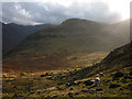
Foot of Coire Hallater
by Richard Webb geograph for square NN1537 In 1988 I was directed to camp here by estate staff. During the evening they... (more)
Tags:
BurnX
type:GeographX
Hanging Valley
top:MoorlandX
top:Rivers, Streams, DrainageX
top:Woodland, ForestX
|
|
Former White's clay pipe factory
by Thomas Nugent geograph for square NS6064 On Bain Street at Moncur Street in The Barras. Category B Listed... (more)
|
|
Logging road, Stank Glen
by Richard Webb geograph for square NN5710 The floor of the upper glen has been left to grow birches or planted with Scots... (more)
|
|
Balquhan Glen
by Richard Webb geograph for square NS8697 The burn has cut a deep gorge as it descends the Ochil scarp.
|
|
Rugged landscape at the head of Cwm Croesor
by Bill Harrison geograph for square SH6646 |
|
Path ascending Coire Dhondail above Loch Eanaich
by Colin Park geograph for square NN9298 The path can be just made out ascending from left to right to the left of the waterfalls.
|
|
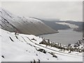
Looking out of Glen Tarken
by Richard Webb geograph for square NN6625 Tags:
type:GeographX
top:Geological InterestX
Hanging Valley
top:Lakes, Wetland, BogX
loch:Loch EarnX
top:Roads, Road TransportX
|
|
Coire Dubh Mòr
by Richard Webb for square NG9557 A glacial trench between Liathach and Beinn Eighe. View from Sgùrr Dubh across... (more)
Tags:
Beinn EigheX
type:Cross GridX
top:Geological InterestX
Hanging Valley
p600 hill:LiathachX
top:MoorlandX
top:Rocks, Scree, CliffsX
p600 hill:Spidean a Choire LeithX
|
|
Head of Loch Affric
by Richard Webb for square NH1421 Some good features here, where the loch is being filled by deposition by the... (more)
Tags:
loch:AffricX
river:AffricX
Alluvial DepositsX
CragsX
type:Cross GridX
top:Geological InterestX
Hanging Valley
top:Lakes, Wetland, BogX
MarshX
top:Rivers, Streams, DrainageX
Truncated SpurX
WaterfallX
|
|
Shaws Water Works
by Thomas Nugent geograph for square NS2775 The main channel enters a tunnel at Nile Street, to re-emerge further west along... (more)
Tags:
top:Derelict, DisusedX
subject:Hanging Valley
top:Historic Sites and ArtefactsX
top:IndustryX
top:Suburb, Urban FringeX
top:Water ResourcesX
|
|
Sourmilk Gill and Raven Crag, Gillercomb
by Karl and Ali geograph for square NY2212 The beck is just leaving the boggy hollow of Gillercomb before starting its... (more)
|