Public Tags
Showing images tagged with lane:Watery Lane tag.
|
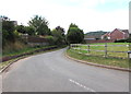
Watery Lane, Monmouth
by Jaggery geograph for square SO4912 Looking to the WSW along Watery Lane from near the Chartist Rise junction.
|
|
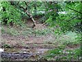
The water by Watery Lane
by Ian Calderwood for square SK3023 Showing evidence of flooding from the previous winter, perhaps explaining how... (more)
Tags:
type:Close LookX
Flood DebrisX
LaneX
top:Rivers, Streams, DrainageX
top:Roads, Road TransportX
subject:StreamX
road:Watery Lane
lane:Watery Lane
|
|
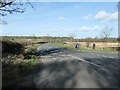
Watery Lane, heading north
by Christine Johnstone geograph for square SE2584 At a 54 metre spot height at the junction with Well Lane and The Avenue.
Tags:
type:GeographX
subject:LaneX
top:Roads, Road TransportX
Spot HeightX
road:Watery Lane
lane:Watery Lane
|
|
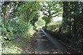
Watery Lane
by J.Hannan-Briggs geograph for square SK2436 Near churchbalk.
|
|
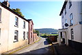
Houses at Dinedor
by John Winder geograph for square SO5237 Houses on Watery Lane, just on the edge of the Rotherwas Industrial Estate near... (more)
|