Geograph - photograph every grid square
About tags on Geograph
Tags
Geographical Context
Subjects
Types
Other Prefixes
Public Tags
Related Tags
|
Coverage Map
Prefix:
ldp
Tag:
Bronte·Way
Other tags:
long distance footpath:
Bronte Way
Showing images tagged with
ldp:
Bronte Way
tag.
View all tagged images
-
In Browser
Search within these images
:
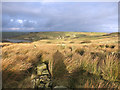
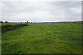
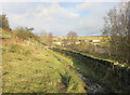
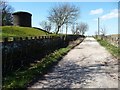
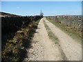
Supposedly the Bronte Way
by
Des Blenkinsopp
geograph for square
SE0433
Between the stone walls is an old road which once served the various ruined... (
more
)
Tags:
ldp:
Bronte Way
Disused Track
X
type:
Geograph
X
top:
Moorland
X
top:
Paths
X
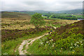
Stone-slabbed path above Saucer Hill Clough
by
Karl and Ali
geograph for square
SD9337
This bridleway has been reinforced with gritstone slabs to accommodate traffic... (
more
)
Tags:
ldp:
Bronte Way
top:
Moorland
X
Moorland View
X
Packhorse Trail
X
top:
Paths
X
ldp:
Pennine Bridleway
X
Stone Slabs
X
top:
Uplands
X
Walker
X
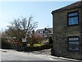
Signpost on the Bronte Way, Haworth
by
Humphrey Bolton
for square
SE0136
This is one of the signposts with a Japanese inscription. Did someone have to... (
more
)
Tags:
ldp:
Bronte Way
type:
Close Look
X
top:
Lowlands
X
top:
Moorland
X
top:
Paths
X
subject:
Sign
X
Signpost
X
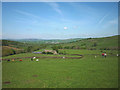
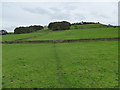
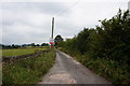
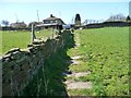
The Bronte Way above Dean House Farm
by
Karl and Ali
geograph for square
SD9438
The Way (one of several named 'ways' in the area) climbs out of the... (
more
)
Tags:
ldp:
Bronte Way
top:
Farm, Fishery, Market Gardening
X
Farmhouse
X
top:
Grassland
X
top:
Housing, Dwellings
X
Pastureland
X
top:
Uplands
X
top:
Village, Rural Settlement
X
Bronte Way towards Jay House Lane
by
Ian S
geograph for square
SE1523
Tags:
ldp:
Bronte Way
top:
Farm, Fishery, Market Gardening
X
type:
Geograph
X
top:
Paths
X
Public Right of Way
X
Footpath from Clayton to Clayton Heights
by
Stephen Craven
geograph for square
SE1131
Part of the Bronte Way.
Tags:
ldp:
Bronte Way
top:
Farm, Fishery, Market Gardening
X
type:
Geograph
X
top:
Paths
X
Public Footpath
X
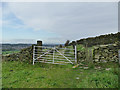
Gate and stile on the Bronte Way
by
Stephen Craven
geograph for square
SE1131
The waymarked path turns left beyond the gate and steeply downhill across the... (
more
)
Tags:
ldp:
Bronte Way
type:
Geograph
X
top:
Lowlands
X
top:
Paths
X
Stone Stile
X
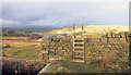
Up and Over on the Bronte Way
by
Des Blenkinsopp
geograph for square
SE0433
Contouring along the hillside to the south of Leeming Reservoir is an artificial... (
more
)
Tags:
ldp:
Bronte Way
type:
Geograph
X
Ladder Stile
X
top:
Paths
X
Stone Wall
X
Bronte Way by Leeming Reservoir
by
Des Blenkinsopp
geograph for square
SE0434
Good views from this bit of the path over the reservoir to the mill and houses... (
more
)
Tags:
ldp:
Bronte Way
type:
Geograph
X
top:
Paths
X
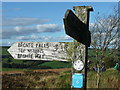
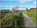
Signpost at a path crossing, Penistone Hill, Haworth
by
Humphrey Bolton
geograph for square
SE0136
The Bronte Way goes to the left; see [[[5139649]] for a close view of the sign.
Tags:
ldp:
Bronte Way
type:
Geograph
X
top:
Moorland
X
top:
Paths
X
Public Footpath
X
Signpost
X
top:
Uplands
X
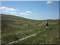
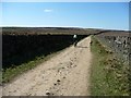
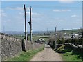
The Bronte Way descending from Penistone Hill, Haworth
by
Humphrey Bolton
geograph for square
SE0136
Tags:
ldp:
Bronte Way
type:
Geograph
X
top:
Moorland
X
subject:
Path
X
top:
Paths
X
Public Footpath
X
top:
Uplands
X
Cyclist heading west on the Bronte Way
by
Christine Johnstone
geograph for square
SE0632
Somewhere round here, Black Edge Lane turns into Thornton Moor Road.
Tags:
ldp:
Bronte Way
Cyclist
X
subject:
Lane
X
top:
Paths
X
Public Footpath
X
top:
Roads, Road Transport
X
top:
Sport, Leisure
X
Unmetalled Track
X
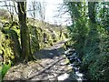
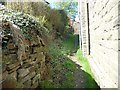
Walled public footpath, alongside Denholme Beck
by
Christine Johnstone
geograph for square
SE0732
Part of the Bronte Way.
Tags:
Beck
X
ldp:
Bronte Way
path:
Footpath
X
Footpath
X
subject:
Path
X
top:
Paths
X
Public Footpath
X
Walled Footpath
X
Clough Lane towards Bailiff Bridge
by
Ian S
geograph for square
SE1524
Tags:
ldp:
Bronte Way
type:
Geograph
X
top:
Paths
X
long distance path:
Spen Way Heritage Trail
X
"Go right up Cragg Lane"
by
Christine Johnstone
geograph for square
SE0732
'Walk the South Pennines' by David Perrott and Laurence Main. Walk 20... (
more
)
Tags:
ldp:
Bronte Way
subject:
Lane Junction
X
Public Footpath
X
top:
Roads, Road Transport
X
Stanbury Heights
by
Mick Garratt
geograph for square
SE0136
Tags:
ldp:
Bronte Way
Footpath
X
type:
Geograph
X
top:
Moorland
X
Moorland
X
National Trail
X
subject:
Path
X
top:
Paths
X
top:
Uplands
X
Air shaft at the water treatment works, Thornton Moor
by
Christine Johnstone
geograph for square
SE0533
Alongside Thornton Moor Road. There are four air shafts below Thornton Moor... (
more
)
Tags:
Air Shaft
X
ldp:
Bronte Way
Minor Moorland Road
X
Public Footpath
X
Unmetalled Track
X
subject:
Water Infrastructure
X
top:
Water Resources
X
Thornton Moor Road at a 364 metre spot height
by
Christine Johnstone
geograph for square
SE0533
Heading north-west below Thornton Moor reservoir
Tags:
ldp:
Bronte Way
path:
Footpath
X
Grass Down the Middle
X
Minor Moorland Road
X
top:
Paths
X
Public Footpath
X
subject:
Road
X
top:
Roads, Road Transport
X
Spot Height
X
Unmetalled Track
X
Black Edge Lane
by
Christine Johnstone
geograph for square
SE0632
Descending to the A629 at Denholme Gate.
Tags:
ldp:
Bronte Way
subject:
Lane
X
top:
Paths
X
Public Footpath
X
top:
Roads, Road Transport
X
Unmetalled Track
X
"Up a path to the A629"
by
Christine Johnstone
geograph for square
SE0732
The house is on the road. 'Walk the South Pennines' by David Perrott... (
more
)
Tags:
ldp:
Bronte Way
public footpath:
Field Edge
X
Flagged Footpath
X
Flagged Path
X
Footpath
X
path:
Footpath
X
subject:
Path
X
top:
Paths
X
Public Footpath
X
"Turn right immediately up a path to the A629"
by
Christine Johnstone
geograph for square
SE0732
On the north side of Cragg Lane. 'Walk the South Pennines' by David... (
more
)
Tags:
ldp:
Bronte Way
Footpath
X
path:
Footpath
X
path:
Narrow Walled
X
subject:
Path
X
top:
Paths
X
Public Footpath
X
View more in the Image Search
or
in Browser
View images matching 'Bronte Way' anywhere
in
the tags
Don't click these:
PotMel 1
PotMel 2
☰
Home
View
Search
Marked Images
Maps
Browser
Explore
Showcase
New Images
Collections
Interact
Games
Discussions
Blog
Contributors
Submit
Statistics
Leaderboards
General
FAQ
Help Pages
Sitemap
Contact Us
Support Us
sponsored by
🔍
What to search:
Photos
Enter keywords or a location/postcode to search nearby images
Enter a Grid Reference
Placenames
Collections
Website Pages
Everything
Others:
Advanced Search
|
Image Browser
Or:
Coverage Map
|
Searchable Map
You are not logged in
login
|
register