Public Tags
Tag: Navigation·Beacon
Showing latest 50 of 378 images tagged with Navigation Beacon tag.
|
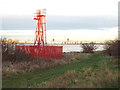
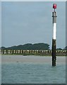
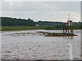
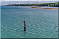
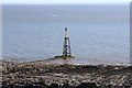
Navigation beacons at the Weaver Turn
by Christine Johnstone geograph for square SJ5079 Where the River Weaver crosses the Manchester Ship Canal and the Weaver... (more)
|
|
Renovation of a navigation beacon near Scurdie Ness
by Adrian Diack geograph for square NO7356 With the sandy Annat Bank to one side and rocks to the other, the mouth of the... (more)
Tags:
top:CoastalX
top:Construction, DevelopmentX
top:Docks, HarboursX
Navigation Beacon
subject:Navigation MarkerX
|
|
Navigation beacon beside the River Severn
by Philip Halling geograph for square ST6196 Navigation beacon beside the River Severn at Shepperdine with aircraft vapour... (more)
|
|
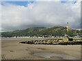
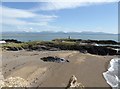
Beacon at Barmouth
by Malc McDonald geograph for square SH6014 A navigation beacon marking the mouth of Afon Mawddach at Barmouth.
The... (more)
Tags:
place:AbermawX
river:Afon MawddachX
Afon MawddachX
place:BarmouthX
place:Barmouth/AbermawX
Beach at Low TideX
top:CoastalX
top:CommunicationsX
type:GeographX
county:GwyneddX
Low TideX
river:MawddachX
Mawddach EstuaryX
area:Mawddach EstuaryX
Navigation Beacon
subject:Navigation MarkerX
beach:SandX
Sands at Low TideX
country:WalesX
|
|
Beacon at Barmouth
by Malc McDonald geograph for square SH6014 A navigation beacon marking the mouth of Afon Mawddach at Barmouth.
The... (more)
Tags:
place:AbermawX
river:Afon MawddachX
Afon MawddachX
place:BarmouthX
place:Barmouth/AbermawX
Beach at Low TideX
top:CoastalX
type:GeographX
county:GwyneddX
Low TideX
river:MawddachX
Mawddach EstuaryX
area:Mawddach EstuaryX
Navigation Beacon
subject:Navigation MarkerX
beach:SandX
Sands at Low TideX
country:WalesX
|
|
Beacon at Barmouth
by Malc McDonald geograph for square SH6014 A navigation beacon marking the mouth of Afon Mawddach at Barmouth. In the... (more)
Tags:
place:AbermawX
river:Afon MawddachX
Afon MawddachX
place:BarmouthX
place:Barmouth/AbermawX
Beach at Low TideX
top:CoastalX
type:GeographX
county:GwyneddX
Low TideX
river:MawddachX
Mawddach EstuaryX
area:Mawddach EstuaryX
Navigation Beacon
subject:Navigation MarkerX
beach:SandX
Sands at Low TideX
country:WalesX
|
|
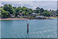
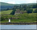
Navigation beacon at Donmouth, Aberdeen
by Malc McDonald geograph for square NJ9509 A coastal navigation beacon at Donmouth, on the outskirts of Aberdeen on... (more)
|
|
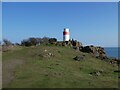
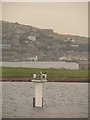
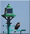
Navigation beacon at Hawkcraig Point
by Oliver Dixon geograph for square NT2084 The lower of two navigation beacons on the headland.
|
|
Navigation beacon at Hawkcraig Point
by Oliver Dixon geograph for square NT2084 The uppermost of two navigation beacons on the point. The steps carry the Fife... (more)
Tags:
subject:BeaconX
top:Docks, HarboursX
type:GeographX
top:Heath, ScrubX
Long Distance PathX
Navigation Beacon
top:PathsX
ScrubX
StepsX
|
|
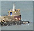
Fishguard - East Breakwater Beacon
by Colin Smith for square SM9538 Navigation beacon on a low tower at the end of the East Breakwater. In the... (more)
Tags:
subject:BreakwaterX
Car Ferry TerminalX
type:Cross GridX
top:Docks, HarboursX
Fishguard HarbourX
Navigation Beacon
Navigational BeaconX
|
|
Navigation beacon at Hawkcraig Point
by Mat Fascione geograph for square NT2084 Hawkcraig Point lies between Aberdour and Silversands Bay. There are two... (more)
Tags:
top:CoastalX
place:Firth of ForthX
type:GeographX
Navigation Beacon
subject:Navigation MarkerX
top:Rocks, Scree, CliffsX
|
|
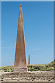
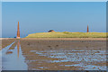
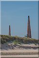
The navigation beacons on Guile Point
by Russel Wills geograph for square NU1340 The nearer East Beacon has a light about one third the way up. Lights were first... (more)
Tags:
top:CoastalX
top:Docks, HarboursX
DunesX
top:Estuary, MarineX
type:GeographX
top:Historic Sites and ArtefactsX
Navigation BeaconsX
subject:Navigation MarkerX
|
|
Guile Point beacons
by Ian Capper geograph for square NU1240 A pair of navigation beacons on Guile Point, known as Guile Point East (or East... (more)
Tags:
top:CoastalX
structure:East Old LawX
type:GeographX
Grade II ListedX
place:Guile PointX
structure:Guile Point EastX
structure:Guile Point WestX
business:Lindisfarne OystersX
Navigation Beacon
place:Old LawX
structure:West Old LawX
|
|
Guile Point beacons
by Ian Capper geograph for square NU1240 A pair of navigation beacons on Guile Point, known as Guile Point East (or East... (more)
Tags:
top:CoastalX
structure:East Old LawX
type:GeographX
Grade II ListedX
place:Guile PointX
structure:Guile Point EastX
structure:Guile Point WestX
Navigation Beacon
place:Old LawX
structure:West Old LawX
|
|
Guile Point beacons
by Ian Capper for square NU1340 A pair of navigation beacons on Guile Point, known as Guile Point East (or East... (more)
Tags:
top:CoastalX
type:Cross GridX
structure:East Old LawX
Grade II ListedX
place:Guile PointX
structure:Guile Point EastX
structure:Guile Point WestX
business:Lindisfarne OystersX
Navigation Beacon
place:Old LawX
structure:West Old LawX
|
|
Navigation light at Cross Ness, near Thamesmead
by Malc McDonald geograph for square TQ4781 A navigation beacon at Cross Ness, on a bend in the River Thames.
Tags:
top:CanalsX
type:GeographX
NavigationX
Navigation Beacon
Navigation LightX
subject:Navigation MarkerX
Navigation MarkerX
river:River ThamesX
top:Rivers, Streams, DrainageX
place:South East LondonX
near:ThamesmeadX
|

|
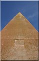
Inscription, Guile Point West
by Ian Capper for square NU1240 An inscription on Guile Point West, one of a pair of navigation beacons on Guile... (more)
Tags:
type:Close LookX
top:CoastalX
Grade II ListedX
place:Guile PointX
structure:Guile Point WestX
Navigation Beacon
place:Old LawX
structure:West Old LawX
|
|
Red Channel Marker/Beacon on the South Side of the Thames
by David Dixon geograph for square TQ6975 This beacon has (relatively recently?) replaced an older beacon further... (more)
Tags:
BeaconX
Channel MarkerX
type:GeographX
Navigation Beacon
Navigation MarkerX
camera:Panasonic DC-G9X
Red MarkerX
RiverX
river:River ThamesX
top:Rivers, Streams, DrainageX
|
|
Guile Point beacons
by Ian Capper geograph for square NU1340 A pair of navigation beacons on Guile Point; known as Guile Point East (or East... (more)
|
|
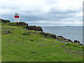
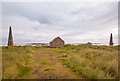
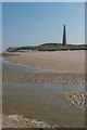
Flotta: beacon on Stanger Head
by Chris Downer geograph for square ND3792 I presume this is a navigation beacon; it is not marked on the Ordnance Survey... (more)
|
|
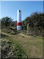
"Roman Transit" beacon
by Rob Farrow geograph for square SU7801 Roman Transit is a navigation beacon at SU7847501745 (50° 48' 36"N 0°... (more)
|
|
Skerry of Ness beacon
by Ian Paterson geograph for square HY2507 Navigation beacon marking the location of the rocky outcrop near the Point of... (more)
Tags:
top:CoastalX
top:Docks, HarboursX
top:Estuary, MarineX
top:IslandsX
Navigation Beacon
top:Water ResourcesX
|
|
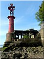
Donald's Quay Light
by Lairich Rig for square NS4572 Category: Navigation beacon (Or Donald's Light; both names are found on old maps. Donald's Quay,... (more)
Tags:
period:19th CenturyX
river:ClydeX
Donalds Quay LightX
top:Estuary, MarineX
Navigation Beacon
near:Old KilpatrickX
|
|
Paignton - Navigation Beacon
by Colin Smith geograph for square SX8960 Beacon just east of Paignton Harbour.
Tags:
top:CoastalX
top:Docks, HarboursX
type:GeographX
Navigation Beacon
subject:Navigation MarkerX
place:PaigntonX
|
|
Guile Point beacons
by Ian Capper geograph for square NU1340 A pair of navigation beacons on Guile Point, known as Guile Point East (or East... (more)
Tags:
top:CoastalX
structure:East Old LawX
East Old LawX
type:GeographX
Grade II ListedX
place:Guile PointX
structure:Guile Point EastX
structure:Guile Point WestX
Navigation Beacon
place:Old LawX
structure:West Old LawX
|
|
Guile Point beacons
by Ian Capper geograph for square NU1340 A pair of navigation beacons on Guile Point; known as Guile Point East (or East... (more)
|
|
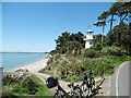
Lepe, Millennium Beacon
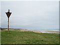
by Mike Faherty geograph for square SZ4498 Erected as a navigation aid for the millennium:... (more)
Tags:
subject:BeaconX
top:CoastalX
top:Estuary, MarineX
Millennium ProjectX
Navigation AidX
Navigation Beacon
|
|
Navigation beacon beside the River Severn
by Philip Halling geograph for square ST6196 Navigation beacon beside the River Severn at Shepperdine
|
|
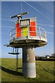
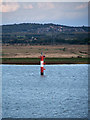
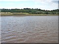
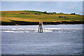
Humber navigation beacon 40
by Christine Johnstone geograph for square SE8824 Seen from the barge Sobriety, heading upstream to Goole on a rising tide.... (more)
Tags:
top:CanalsX
river:HumberX
Navigable RiverX
Navigation Beacon
Rising TideX
top:Rivers, Streams, DrainageX
Tidal RiverX
|
|
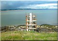
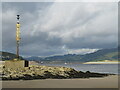
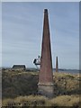
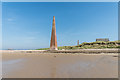
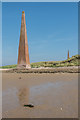
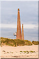
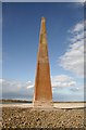
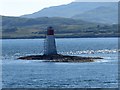
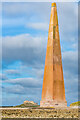
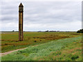
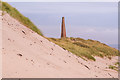
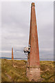
West Old Law Beacon
by Walter Baxter for square NU1340 This is a view up the west face of the 83 foot (25.3m) high navigational beacon... (more)
Tags:
top:CoastalX
Navigation Beacon
|
|
West Old Law Beacon
by Walter Baxter geograph for square NU1340 There are two navigational beacons at Guile Point on the south side of the... (more)
Tags:
top:CoastalX
Navigation Beacon
|
|
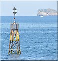
Beacon 4
by Ian Capper geograph for square SZ5593 Beacon 4, one of the navigation beacons marking the entrance to Fishbourne car... (more)
|
|
Beacon 2
by Ian Capper for square SZ5693 Beacon 2, one of the navigation beacons marking the entrance to Fishbourne car... (more)
|
|
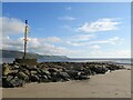
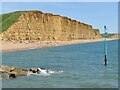
West Bay - Navigation Beacon
by Colin Smith for square SY4690 Beacon by the end of the East Breakwater at the mouth of West Bay Harbour.
|
|
Lady's Rock and beacon
by Rob Farrow geograph for square NM7734 Lady's Rock is a skerry to the south west of Eilean Musdile. It is... (more)
|
|
No 44 Cliff End navigation beacon
by Christine Johnstone geograph for square SE8620 A 'quick flashing red' navigation light on the east bank of the Trent.... (more)
Tags:
Navigable RiverX
Navigation Beacon
Navigation LightX
colour:RedX
subject:River BankX
top:Rivers, Streams, DrainageX
Tidal RiverX
river:TrentX
|
|
Ardtornish Castle and Beacon
by Rob Farrow for square NM6942 A view from our passing CalMac ferry of Ardtornish Point with its C13th castle... (more)
Tags:
place:ArdtornishX
BeaconX
CastleX
top:CoastalX
type:Cross GridX
top:Historic Sites and ArtefactsX
Navigation Beacon
subject:PromontoryX
Sound of MullX
|
|
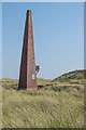
Fishguard - East Breakwater Beacon
by Colin Smith for square SM9538 Navigation beacon on a low tower at the end of the East Breakwater protecting... (more)
Tags:
subject:BeaconX
BreakwaterX
top:CommunicationsX
type:Cross GridX
top:Docks, HarboursX
Fishguard HarbourX
Navigation Beacon
|
|
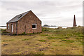
Navigation Beacon south of Mell Head
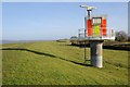
by David Dixon geograph for square ND3475 The beacon stands on a skerry that extends some distance out from the shore.
Tags:
CliffsX
top:CoastalX
top:Docks, HarboursX
type:GeographX
top:IslandsX
Navigation Beacon
camera:Panasonic DMC-G7X
Pentland FirthX
Ruined ChurchX
Ruined HousesX
StromaX
Warning BeaconX
|
|
Guile Point West
by Ian Capper geograph for square NU1240 Otherwise known as West Old Law, this is one of a pair of navigation beacons on... (more)
Tags:
top:CoastalX
type:GeographX
Grade II ListedX
place:Guild PointX
place:Guile PointX
structure:Guile Point WestX
building:Lindisfarne CastleX
Navigation Beacon
structure:West Old LawX
|
|
West Bay - Navigation Beacon
by Colin Smith geograph for square SY4690 Beacon by the end of the East Breakwater at the mouth of West Bay Harbour.
The... (more)
Tags:
subject:BeaconX
CliffX
top:CoastalX
top:Docks, HarboursX
type:GeographX
top:Geological InterestX
Jurassic CoastX
Navigation Beacon
top:Rocks, Scree, CliffsX
place:West BayX
|
|
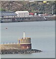
Rampside Lighthouse
by David Dixon geograph for square SD2466 Number 4 Rampside Leading Light, also known as "The Needle" or... (more)
|
|
Guile Point East
by Ian Capper for square NU1340 One of a pair of navigation beacons on Guile Point, this one otherwise known as... (more)
Tags:
type:Close LookX
top:CoastalX
structure:East Old LawX
Grade II ListedX
place:Guile PointX
structure:Guile Point EastX
Navigation Beacon
place:Old LawX
|
|
Guile Point East
by Ian Capper geograph for square NU1340 One of a pair of navigation beacons on Guile Point, this one otherwise known as... (more)
Tags:
top:CoastalX
structure:East Old LawX
type:GeographX
Grade II ListedX
place:Guile PointX
structure:Guile Point EastX
Navigation Beacon
place:Old LawX
|
|
Beacon, Cold Knapp Point
by M J Roscoe for square ST1065 Navigation beacon viewed at low water from Cold Knapp.
Tags:
subject:BeaconX
top:CoastalX
type:Cross GridX
Navigation Beacon
top:PathsX
top:Rocks, Scree, CliffsX
Sea ShoreX
|
|
Twr Bach from Twr Mawr
by Eirian Evans geograph for square SH3862 The smaller and earlier of the two beacons on Ynys Llanddwyn. For nearly 130... (more)
Tags:
BayX
subject:BeaconX
top:CoastalX
top:CommunicationsX
top:Estuary, MarineX
top:IslandsX
Navigation Beacon
RocksX
|
|
Lindisfarne Oysters
by Ian Capper geograph for square NU1340 The Lindisfarne Oysters building at Guile Point, who farm Pacific Oysters in the... (more)
|
|
Guile Point East
by Ian Capper geograph for square NU1340 Otherwise known as East Old Law, this is one of a pair of navigation beacons on... (more)
|
|
Guile Point East
by Ian Capper geograph for square NU1340 Otherwise known as East Old Law, this is one of a pair of navigation beacons on... (more)
|