Public Tags
Other tags: Blubberhouses
Showing images tagged with near:Blubberhouses tag.
|
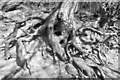
Tree roots
by John Winder for square SE1954 A gratuitously arty shot of some gnarled tree roots near Fewston dam.
Tags:
near:Blubberhouses
Fewston DamX
Fewston ReservoirX
subject:TreeX
Tree RootsX
top:Woodland, ForestX
|
|
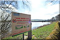
Cold Water Kills
by John Winder geograph for square SE1952 I had no idea ... I keep a bottle in the fridge but I didn't realise it was... (more)
Tags:
near:Blubberhouses
SignX
subject:SignX
Swinsty ReservoirX
Warning SignX
Washburn ValleyX
top:Water ResourcesX
|
|
Fishing at Fewston
by John Winder geograph for square SE1853 Standing waist deep in water all day isn't my idea of fun, I must admit.... (more)
Tags:
near:Blubberhouses
Fewston DamX
Fewston ReservoirX
FishermenX
subject:FishingX
FishingX
top:Sport, LeisureX
Washburn ValleyX
top:Water ResourcesX
|

|
Fishing at Fewston
by John Winder for square SE1853 A closer view - taken from Fewston Dam with my 80-200mm lens - of one of the... (more)
Tags:
near:Blubberhouses
Fewston DamX
Fewston ReservoirX
FishermanX
subject:FishingX
FishingX
top:Sport, LeisureX
top:Water ResourcesX
|
|
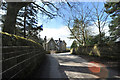
Fewston Dam
by John Winder geograph for square SE1854 A view along the dam separating Fewston and Swinsty reservoirs. Fewston Cottage... (more)
Tags:
near:Blubberhouses
Fewston CottageX
Fewston DamX
Fewston ReservoirX
subject:Reservoir InfrastructureX
Washburn ValleyX
top:Water ResourcesX
|

|
Fewston Reservoir outflow
by John Winder for square SE1853 The outflow which feeds Swinsty Reservoir, which is in the foreground. Taken... (more)
Tags:
near:Blubberhouses
Fewston DamX
Fewston ReservoirX
subject:Reservoir OutflowX
Swinsty ReservoirX
river:WashburnX
top:Water ResourcesX
|
|
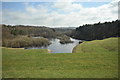
Swinsty Reservoir from Fewston Dam
by John Winder geograph for square SE1854 There are four reservoirs along the Washburn Valley: Thruscross (constructed in... (more)
Tags:
near:Blubberhouses
Fewston DamX
subject:ReservoirX
Swinsty ReservoirX
Washburn ValleyX
top:Water ResourcesX
|
|
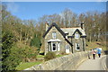
Fewston Cottage
by John Winder geograph for square SE1854 A picturesque cottage at the end of Fewston Dam.
Tags:
near:Blubberhouses
Fewston CottageX
Fewston DamX
Fewston ReservoirX
top:Housing, DwellingsX
top:Water ResourcesX
|
|
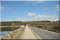
View along the Washburn Valley
by John Winder geograph for square SE1952 Taken in black & white with a red filter on the lens. This is the rather... (more)
Tags:
near:Blubberhouses
DamX
top:Rivers, Streams, DrainageX
Swinsty ReservoirX
subject:ViewX
river:WashburnX
Washburn ValleyX
top:Water ResourcesX
|
|
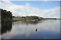
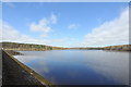
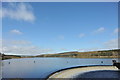
Swinsty Reservoir
by John Winder geograph for square SE1952 A general view of Swinsty Reservoir, beneath which are the remains of New Hall,... (more)
|
|
Swinsty Cottage
by John Winder geograph for square SE1952 Situated right on the end of Swinsty Embankment (the dam which holds back the... (more)
Tags:
near:Blubberhouses
CottageX
subject:CottageX
top:Housing, DwellingsX
Swinsty CottageX
Swinsty ReservoirX
top:Water ResourcesX
|
|
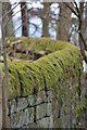
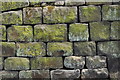
Wall at Swinsty Reservoir
by John Winder for square SE1953 The reservoir is completely enclosed by dry stone walls, beautifully constructed... (more)
Tags:
near:Blubberhouses
Dry Stone WallX
Dry Stone WallingX
Swinsty ReservoirX
subject:WallX
top:Water ResourcesX
|
|
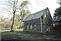
Pump house at Swinsty
by John Winder geograph for square SE1952 As the title says, this is a pump house at Swinsty. The reservoir was built... (more)
Tags:
near:Blubberhouses
MachineryX
PumpX
Pump HouseX
Pumping HouseX
subject:Reservoir InfrastructureX
Swinsty ReservoirX
top:Water ResourcesX
|
|
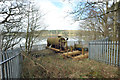
Derelict machinery at Swinsty Reservoir
by John Winder geograph for square SE1953 Don't know what this did, but it hasn't done it for a long time! Rusty... (more)
Tags:
near:Blubberhouses
subject:MachineryX
MachineryX
PumpX
RustyX
Swinsty ReservoirX
top:Water ResourcesX
|
|
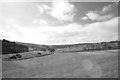
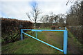
Car Park for the Disabled Angler
by John Winder geograph for square SE1953 It's not easy to read in this shot, but that's what the sign on the... (more)
Tags:
near:Blubberhouses
GateX
subject:SignX
SignX
top:Sport, LeisureX
Swinsty ReservoirX
top:Water ResourcesX
|
|
Stonework
by John Winder for square SE1953 The whole of Swinsty Reservoir is bordered by these beautifully constructed dry... (more)
Tags:
near:Blubberhouses
Dry Stone WallX
Dry Stone WallingX
Swinsty ReservoirX
subject:WallX
top:Water ResourcesX
|
|
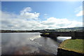
Swinsty Reservoir weir and outflow
by John Winder geograph for square SE1952 The horseshoe weir which controls the level of Swinsty Reservoir in the Washburn... (more)
|

|
Swinsty Reservoir outflow
by John Winder geograph for square SE1952 The channel which takes the overflow from Swinsty Reservoir down to the Washburn Valley.
|
|
Fishermen at Fewston
by John Winder geograph for square SE1853 Five fishermen stand waist deep in the shallow end of Fewston Reservoir, just... (more)
Tags:
near:Blubberhouses
Fewston ReservoirX
FishermenX
subject:FishingX
top:Sport, LeisureX
top:Water ResourcesX
|