Public Tags
Showing images tagged with near:Glendale tag.
|
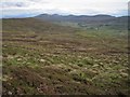
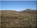
Miles of moorland
by Richard Dorrell geograph for square NG1751 Looking south east over the west facing slope of Scoval. Buildings in Glendale... (more)
|
|
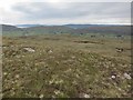
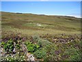
North east over the moor
by Richard Dorrell geograph for square NG1747 The hillside vegetation is grasses, heather and moss. In the distance, crofting... (more)
|
|
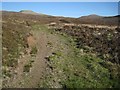
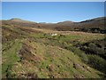
Track from Fasach
by Richard Dorrell geograph for square NG1946 The photographer is standing on a track which used to provide a route From... (more)
|
|
Sunagill
by Richard Dorrell geograph for square NG2045 A number of burns begin in the gently sloping moorland and join to become the... (more)
|
|
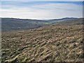
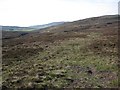
Typical Duirinish scenery
by Richard Dorrell geograph for square NG1947 Pretty much all of the Duirinish Peninsula on Skye consists of lumpy and largely... (more)
|
|
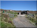
Water treatment works, Fasach
by Richard Dorrell geograph for square NG1947 A Scottish Water installation, tucked away on the hillside at the southern end... (more)
|
|
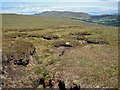
Peat hags on Ben Corkeval
by Richard Dorrell geograph for square NG1845 This would be a tricky place to be walking in wet weather. The distant buildings... (more)
|
|
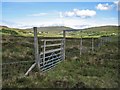
Gate in the deer fence
by Richard Dorrell geograph for square NG1847 A very large area of the hillside on the west side of the Hamara River south of... (more)
|
|
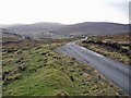
Road into Glendale
by Richard Dorrell geograph for square NG1850 The road is descending towards Glasphein and Feriniquarrie. The road crosses the... (more)
|
|
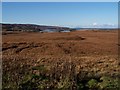
Moorland towards Loch Erghallan
by Richard Dorrell geograph for square NG2347 Category: moorland Viewed from the side of the B884 road to Glendale.
The white dots on the left... (more)
|
|
View over the rock
by Richard Dorrell geograph for square NG1745 Looking down Bràigh na Cloiche from on top of the hillock that lies behind an... (more)
|
|
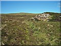
Rock outcrop on Beinn nan Corrafidheag
by Richard Dorrell geograph for square NG1746 The eastern slopes of the hill are largely featureless heather moorland. The... (more)
Tags:
place:Beinn Nan CorrafidheagX
near:Glendale
Heather MoorlandX
place:Isle of SkyeX
top:MoorlandX
Rock OutcropX
|
|
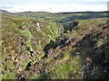
Allt Dearg gorge, upstream from a crossing point
by Richard Dorrell geograph for square NG1846 It is possible to scramble down one side of the gorge and up the other at this... (more)
|
|
Allt Dearg gorge, crossing point
by Richard Dorrell geograph for square NG1846 Towards the top of the gorge, it is possible to scramble down one side and up... (more)
|
|
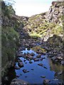
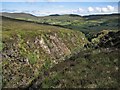
Allt Dearg gorge
by Richard Dorrell geograph for square NG1846 This view is downstream. The impressive gorge is very deep, straight and narrow,... (more)
|
|
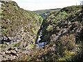
Allt Dearg gorge
by Richard Dorrell geograph for square NG1846 This view is upstream. The impressive gorge is narrow, straight and vertically-sided
|
|
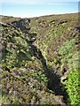
Allt Dearg gorge
by Richard Dorrell geograph for square NG1847 The small burn flows through a deep and very narrow gorge just here. The burn is... (more)
|
|
An Leth Pheighinn
by Richard Dorrell geograph for square NG1946 The lonely ruin of a former dwelling (latterly used as a sheep pen) lies by a... (more)
Tags:
top:Derelict, DisusedX
near:Glendale
Heather MoorlandX
top:Housing, DwellingsX
place:Isle of SkyeX
top:MoorlandX
RuinX
top:UplandsX
|
|
Shieling hut remains
by Richard Dorrell geograph for square NG1946 Shieling huts were usually built of low stone and turf walls with a heather... (more)
Tags:
near:Glendale
Heather MoorlandX
top:Housing, DwellingsX
place:Isle of SkyeX
top:MoorlandX
ShielingX
ruin:Shieling HutX
top:UplandsX
|
|
Track towards Fasach
by Richard Dorrell geograph for square NG2045 There is a followable track leading to Fasach from here, though it becomes less... (more)
|
|
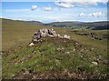
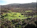
Shielings above the gorge
by Richard Dorrell geograph for square NG1847 The patch of green grass and scattering of stones on the moor, centrally in this... (more)
Tags:
top:Derelict, DisusedX
near:Glendale
GorgeX
Heather MoorlandX
top:Housing, DwellingsX
place:Isle of SkyeX
top:MoorlandX
top:Rivers, Streams, DrainageX
ShielingsX
|