Public Tags
Prefix:
near
Tag:
Llangollen
Showing images tagged with near:Llangollen tag.
|
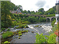
River Dee as viewed from The Chainbridge Hotel, Llangollen
by Robin Drayton
geograph for square SJ1943
The lower bridge is a road bridge (B5143) named King's Bridge and... (more)
|
|
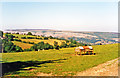
View NE nearing Llangollen on road from Glyn Ceiriog, 1995
by Ben Brooksbank
geograph for square SJ2141
Prominent beyond Llangollen are the cliffs of the Eglwyseg. [The precise... (more)
|
|
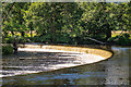
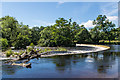
Horseshoe Falls
by Ian Capper
geograph for square SJ1943
A weir on the River Dee, built by Thomas Telford in the first decade of the 19th... (more)
|
|
Horseshoe Falls
by Ian Capper
geograph for square SJ1943
A weir on the River Dee, built by Thomas Telford in the first decade of the 19th... (more)
|
|
Horseshoe Falls
by Ian Capper
geograph for square SJ1943
A weir on the River Dee, built by Thomas Telford in the first decade of the 19th... (more)
|
|
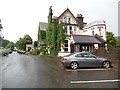
White Waters Country Hotel, Llangollen
by David Hillas
geograph for square SJ2043
Situated on the A5 Berwyn Road LL20 8BH, this country hotel was originally a... (more)
|
|
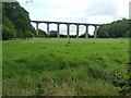
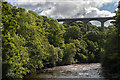
Pontcysyllte Aqueduct
by James Allan
for square SJ2742
Thomas Telford's aqueduct on the Llangollen canal.
|
|
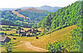
Westward up Dee Valley to Llantisilio Mountains (Moel Morfydd, 1,801 ft.) from just south of Llangollen, 1995
by Ben Brooksbank
geograph for square SJ2141
View westward from road from Glyn Ceiriog, over village of Ffynnon-las.
|
|
Pontcysyllte Aqueduct from Cysylltau Bridge
by Oliver Mills
geograph for square SJ2642
A dramatic view of the famous Aqueduct, from another historical bridge. The... (more)
|
|
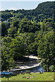
Westward from top of Horseshoe Pass on A542 over Maesyrychen Mountain, 1995
by Ben Brooksbank
geograph for square SJ1948
Opposite the Ponderosa Café.
|