Geograph - photograph every grid square
About tags on Geograph
Tags
Geographical Context
Subjects
Types
Other Prefixes
Public Tags
Related Tags
|
Coverage Map
Prefix:
near
Tag:
The·Crown·Public·House
Other tags:
The Crown Public House
on:
The Crown Public House
Showing images tagged with
near:
The Crown Public House
tag.
View all tagged images
-
In Browser
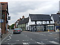
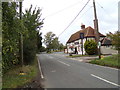
B1077 Denmark Street, Diss
by
Geographer
geograph for square
TM1180
At the junction with St.Nicholas Street near The Crown Public House
Tags:
B Road (Classified B)
X
B1077
X
B1077 Denmark Street
X
Denmark Street
X
at:
Diss
X
Public House
X
subject:
Road Junction
X
top:
Roads, Road Transport
X
St.Nicholas Street
X
The Crown
X
The Crown Public House
near:
The Crown Public House
B1125 The Street, Westleton
by
Geographer
geograph for square
TM4368
Category: B road (Classified B)
Looking towards Yoxford Road near the junction with Darsham Road & near The... (
more
)
Tags:
B1125
X
B1125 The Street
X
Darsham Road
X
Public House
X
subject:
Road Junction
X
top:
Roads, Road Transport
X
The Crown
X
near:
The Crown Public House
The Street
X
at:
Westleton
X
looking towards:
Yoxford Road
X
B1077 Denmark Street, Diss
by
Geographer
geograph for square
TM1180
Approaching the junction with St.Nicholas Street near The Crown Public House
Tags:
B Road (Classified B)
X
B1077
X
B1077 Denmark Street
X
Denmark Street
X
at:
Diss
X
Diss
X
Public House
X
subject:
Road Junction
X
top:
Roads, Road Transport
X
The Crown
X
near:
The Crown Public House
approaching:
The Junction with St.Nicholas Street
X
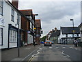
B1068 Park Street, Stoke By Nayland
by
Geographer
geograph for square
TL9836
Near The Crown Public House
Tags:
B Road (Classified B)
X
B1068
X
B1068 Park Road
X
Park Road
X
Public House
X
subject:
Road
X
top:
Roads, Road Transport
X
at:
Stoke By Nayland
X
near:
The Crown Public House
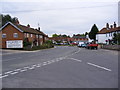
B1508 Main Road, Wormingford
by
Geographer
for square
TL9231
Near The Crown Public House
Tags:
B Road (Classified B)
X
B1508
X
B1508 Main Road
X
type:
Cross Grid
X
subject:
Road
X
top:
Roads, Road Transport
X
near:
The Crown Public House
top:
Village, Rural Settlement
X
at:
Wormingford
X
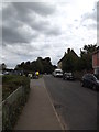
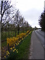
Floral Edging and the B1438 High Street
by
Geographer
geograph for square
TM2952
Category: Floral display
Looking towards the B1438 Yarmouth Road near The Crown Public House
Tags:
B Road (Classified B)
X
B1438
X
B1438 High Street
X
top:
Communications
X
Floral Edging
X
subject:
Flower Bed
X
High Street
X
top:
Roads, Road Transport
X
looking towards:
The B1438 Yarmouth Road
X
near:
The Crown Public House
at:
Ufford
X
top:
Wild Animals, Plants and Mushrooms
X
Yarmouth Road
X
View more in the Image Search
or
in Browser
View images matching 'The Crown Public House' anywhere
in
the tags
Don't click these:
PotMel 1
PotMel 2
☰
Home
View
Search
Marked Images
Maps
Browser
Explore
Showcase
New Images
Collections
Interact
Games
Discussions
Blog
Contributors
Submit
Statistics
Leaderboards
General
FAQ
Help Pages
Sitemap
Contact Us
Support Us
sponsored by
🔍
What to search:
Photos
Enter keywords or a location/postcode to search nearby images
Enter a Grid Reference
Placenames
Collections
Website Pages
Everything
Others:
Advanced Search
|
Image Browser
Or:
Coverage Map
|
Searchable Map
You are not logged in
login
|
register