Public Tags
Other tags: East Lomond Hill
Showing images tagged with p150 hill:East Lomond Hill tag.
|
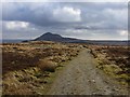
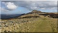
Track, Lomond Hills
by Richard Webb geograph for square NO2106 A well surfaced track across the plateau makes an ascent of West Lomond Hill... (more)
Tags:
p150 hill:East Lomond Hill
p150 hill:Falkland HillX
top:MoorlandX
top:PathsX
p150 hill:West Lomond HillX
|
|
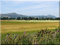
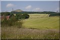
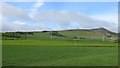
Howe of Fife
by Richard Webb geograph for square NO2709 Barley and in the distance, wheat grows on flat fertile soil beneath the Lomond Hills.
Tags:
p150 hill:East Lomond Hill
p150 hill:Falkland HillX
top:Farm, Fishery, Market GardeningX
p150 hill:West Lomond HillX
|
|
Field, Honeyhall
by Richard Webb geograph for square NO3306 Arable land at the site of a building called Honeyhall on old maps. There is a... (more)
Tags:
p150 hill:East Lomond Hill
p150 hill:Falkland HillX
top:Farm, Fishery, Market GardeningX
p150 hill:West Lomond HillX
|
|
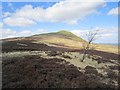
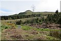
East Lomond
by Richard Webb geograph for square NO2505 A single tree on moorland to the east of Falkland Hill (or East Lomond).
|
|
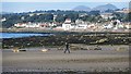
Beach, Dumbarnie Links
by Richard Webb geograph for square NO4302 View towards Lower Largo and a novel (to me) presentation of the Paps of Fife.... (more)
Tags:
BeachX
top:CoastalX
p150 hill:East Lomond Hill
p150 hill:Falkland HillX
top:Village, Rural SettlementX
p150 hill:West Lomond HillX
|
|
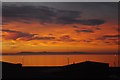
Sunset over the Firth of Forth
by Richard Webb for square NT3975 A particularly fine sunset with a view of the Paps of Fife. Anyone tempted by... (more)
Tags:
top:Air, Sky, WeatherX
p150 hill:Bishop HillX
top:CoastalX
p150 hill:East Lomond Hill
p150 hill:Falkland HillX
p150 hill:West Lomond HillX
|
|
Stubble, Lomond Hills
by Richard Webb geograph for square NO2404 View towards East Lomond or Falkland Hill.
|
|
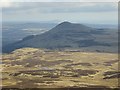
Falkland Hill
by Richard Webb for square NO2406 Also known as East Lomond, the hill is a major landmark in eastern Scotland and... (more)
|
|
New fence, Lomond Hills
by Richard Webb geograph for square NO2206 The well surfaced path across from West Lomond carries on as a road between two... (more)
Tags:
p150 hill:East Lomond Hill
p150 hill:Falkland HillX
top:Farm, Fishery, Market GardeningX
FenceX
top:PathsX
Rough GrazingX
|
|
Path, Lomond Hills
by Richard Webb geograph for square NO2106 The big and well surfaced path between West Lomond and the Leslie to Falkland... (more)
|
|
Path from Craigmead Quarry
by Richard Webb geograph for square NO2206 A view past the trees which surround the car park towards East Lomond or Falkland Hill.
Tags:
p150 hill:East Lomond Hill
p150 hill:Falkland HillX
top:Farm, Fishery, Market GardeningX
top:PathsX
Rough GrazingX
|
|
Loch Ore Meadows Country Park
by Richard Webb geograph for square NT1695 Reclaimed mining land around Loch Ore. There is a view of Falkland Hill /East... (more)
Tags:
p150 hill:East Lomond Hill
p150 hill:Falkland HillX
railway:Kinross-ShireX
top:Lakes, Wetland, BogX
Mining SubsidenceX
railway:North British RailwayX
loch:OreX
top:Park and Public GardensX
top:RailwaysX
|
|
West Conland
by Richard Webb geograph for square NO2504 Barley in the Lomond Hills. The rough foreground is the edge of the Formonthills woodland.
|
|
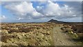
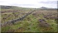
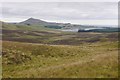
Moorland, Lomond Hills
by Richard Webb for square NO2106 A moorland plateau between the two main summits. Much of the land is rough and tussocky.
|
|
Moorland, Lomond Hills
by Richard Webb geograph for square NO2206 This area is still labelled Bracks Plantation on Ordnance Survey maps although... (more)
|
|
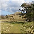
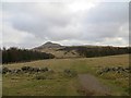
View towards Falkland Hill
by Richard Webb geograph for square NO2206 The path is leaving the Craigmead Quarry car park for West Lomond.
Tags:
p150 hill:East Lomond Hill
p150 hill:Falkland HillX
top:Farm, Fishery, Market GardeningX
Rough GrazingX
|
|
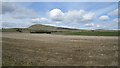
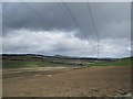
Newly tilled ground on Craigend Hill
by Richard Webb geograph for square NO2000 View along the powerlines towards the Lomond Hills.
Tags:
p150 hill:East Lomond Hill
top:Energy InfrastructureX
p150 hill:Falkland HillX
top:Farm, Fishery, Market GardeningX
Power LineX
|
|
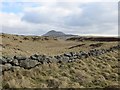
Path on Bishop Hill
by Richard Webb geograph for square NO1905 The path leads from the head of Glen Vale to Bishop Hill.
|
|
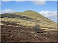
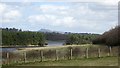
On Bishop Hill
by Richard Webb geograph for square NO1805 View towards Harperleas and Ballo Reservoirs from the northern end of Bishop Hill.
Tags:
p150 hill:East Lomond Hill
p150 hill:Falkland HillX
type:GeographX
top:MoorlandX
ReservoirsX
top:Water ResourcesX
|
|
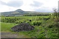
Hairyholes Plantation
by Richard Webb geograph for square NO2603 Woodland area with a dense path network outside Glenrothes.
|
|
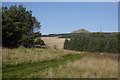
Fields near Freuchie
by Richard Webb geograph for square NO2706 View of Falkland Hill.
|
|
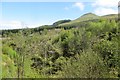
Maspie Den
by Richard Webb geograph for square NO2306 Looking over the glen from above the waterfall. The road to Leslie runs close to... (more)
|
|
Woodland, Falkland
by Richard Webb geograph for square NO2307 A felled area gives a view of Falkland Hill.
|
|
Pillars of Hercules camping field
by Richard Webb geograph for square NO2308 A view towards Falkland Hill.
Tags:
top:Business, Retail, ServicesX
p150 hill:East Lomond Hill
p150 hill:Falkland HillX
top:Farm, Fishery, Market GardeningX
national cycle network:Route 1X
top:Sport, LeisureX
|
|
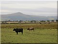
Cattle near Easter Kilwhiss
by Richard Webb geograph for square NO2711 Wetland grazing near Rossie Bog.
|
|
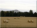
Round bales, Easter Lathrisk
by Richard Webb geograph for square NO2808 View towards Falkland Hill.
|
|
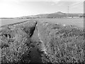
Auchtermuchty Burn
by Richard Webb geograph for square NO2510 Here a drainage ditch on the flat Howe of Fife.
Tags:
BurnX
DrainX
p150 hill:East Lomond Hill
p150 hill:Falkland HillX
top:Rivers, Streams, DrainageX
|
|
Field above Leslie
by Richard Webb geograph for square NO2300 Farmland on igneous rock with a view towards Falkland Hill.
|
|
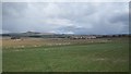
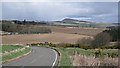
Minor road, Auchmuir
by Richard Webb geograph for square NO2200 A climb southwards from the Leven with Falkland Hill in the background.
Tags:
p150 hill:East Lomond Hill
p150 hill:Falkland HillX
top:Farm, Fishery, Market GardeningX
top:Roads, Road TransportX
|
|
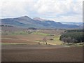
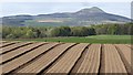
Cultivated fields, Carriston
by Richard Webb for square NO3104 Neat rows of drying earth with a view towards Falkland Hill.
|