Public Tags
Tag: Peat·Hags
Showing latest 50 of 207 images tagged with Peat Hags tag.
|
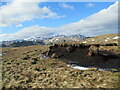
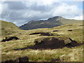
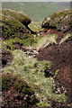
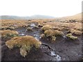
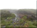
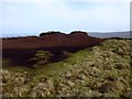
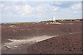
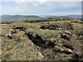
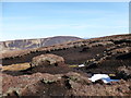
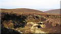
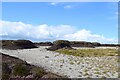
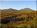
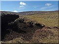
Peat hags north-west of Sròn na Maoile
by Alan O'Dowd geograph for square NN6817 Eroded remnants of peat cover on the hillside, with the snowy peak of Ben... (more)
Tags:
top:Air, Sky, WeatherX
Eroding PeatX
Erosion of Peat CoverX
type:GeographX
top:MoorlandX
subject:PeatX
Peat HagX
Peat Hags
Snow Covered MountainsX
top:UplandsX
|
|
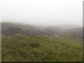
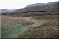
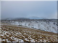
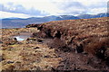
Peat hags and Ben Skriaig
by Richard Dorrell geograph for square NG1752 My title sounds like two of the nicest chaps you could wish to meet...
However,... (more)
|
|
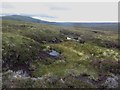
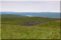
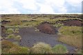
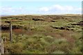
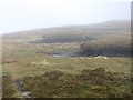
Peat hags on Creag nan Gabhar
by Iain Russell geograph for square NO1683 Peat hags and bogs on the eastern slopes of Creag nan Gabhar.
|
|
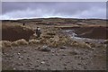
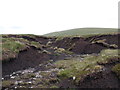
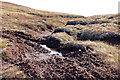
Peat hags near Dun Muir
by Alan O'Dowd geograph for square NJ2718 A view towards Letterach from the extensive peat hags west of Dun Muir.
|
|
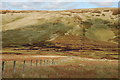
Peat hags on hillside above Sgiath an Dobhrain
by Alan O'Dowd geograph for square NN6214 The spur on the end of this section of hillside has the name Sgiath an Dobhrain... (more)
|
|
Peat hags on the hill
by Graham Robson geograph for square NJ0707 Peat hags on the hillside to the south of Cnap na Cul-ath.
|
|
Peat hags east of Hartfell Rig
by Jim Barton geograph for square NT1314 Peat hags on the col, spot height 608m, E of Hartfell Rig.
|
|
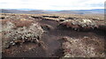
Exposed Peat on Kinder Scout
by Mick Garratt geograph for square SK0789 This should act as a giant sponge of water but retreat of the heather has... (more)
Tags:
ErosionX
top:Lakes, Wetland, BogX
Open AccessX
Open Access LandX
Peak DistrictX
place:Peak DistrictX
PeatX
Peat BogsX
Peat HagX
Peat Hags
Peat MoorX
season:SummerX
top:UplandsX
|
|
Peat hags on West Hill
by Walter Baxter geograph for square NT8921 The area around the Cheviot plateau is notorious for glutinous peat hags but... (more)
|
|
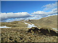
Peat hag and snow patches on Sròn na Maoile
by Alan O'Dowd geograph for square NN6817 Remnants of eroded peat on Beinn Dearg, above Glen Artney.
Tags:
top:Air, Sky, WeatherX
Eroding PeatX
Erosion of Peat CoverX
type:GeographX
top:MoorlandX
subject:PeatX
Peat Hags
Snow PatchesX
top:UplandsX
|
|
Hags near Loch Vrotachan
by Iain Russell geograph for square NO1178 Large areas of peat hags form much of the moorland here. The Munro An Socach can... (more)
|
|
Peat hags on The Nab
by Graham Robson geograph for square NY4314 Peat hags encountered on the path between Rest Dodd and the top of The Nab.
|
|
Crossing Peat Hags on The Nab
by Graham Robson geograph for square NY4314 The path between Rest Dodd and The Nab crosses the peat hags situated at the low... (more)
|
|
Peat Hags on Little Whernside
by Graham Robson geograph for square SE0277 The peat hag covered summit of Little Whernside. Finding the summit was somewhat... (more)
|
|
Peat Hags above the Feith Buidhe
by Graham Robson geograph for square NJ0808 Mercifully dry peat hags on the gentle slopes above the Feith Buidhe burn.
|
|
Peat hags north of Coire Riabhach Bheag
by Graham Robson geograph for square NJ0706 Peat hags on the hill to the north of Coire Riabhach Bheag.
|
|
Peat Hags near Sugar Loaf
by Graham Robson geograph for square SD8976 Very wet looking peat hags near Sugar Loaf, the highest point on Horse Head Moor.
|
|
Peat hags on Kirk Gill Moor
by Graham Robson geograph for square SD9176 Lurking in low cloud peat hags cover the top of Kirk Gill Moor.
|
|
Hagiau Mawn / Peat Hags
by Ian Medcalf geograph for square SN8069 Hagiau Mawn gyda Chronfa Ddŵr Claerwen y tu ol / Peat Hags with Claerwen... (more)
|
|
Peat hags on Knocklaur
by Jim Barton geograph for square L9363 Peat hags near this grassy summit east of the Devilsmother.
|
|
Scroo Summit Peat Hags
by Rude Health geograph for square HU4029 Last TuMP of the day with Tricky Speirs, over peat hags from Holmfield and Royl... (more)
|
|
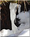
An icicle in a peat hag
by Jim Barton for square NT2026 A miniature ice landscape by a snow-filled peat hag at about 580m on Redsike... (more)
|
|
Peat hags, Gleann Riabhach
by Jim Barton geograph for square NN4705 Peat hags occupy this level boggy ground high in the glen below the final rise... (more)
|
|
Peat Haggs, Kinder Scout
by Mick Garratt geograph for square SK0887 |
|
Kinder Scout Trig. Point
by Mick Garratt geograph for square SK0789 Clearing showing the effect of peat erosion and shrinkage.
|
|
Peat Hags on Crowden Head
by Mick Garratt geograph for square SK0988 Tags:
GroughX
top:Heath, ScrubX
Heather MoorX
MoorX
Open AccessX
Open Access LandX
place:Peak DistrictX
Peak DistrictX
PeatX
Peat BogX
Peat HagX
Peat MoorX
top:Rivers, Streams, DrainageX
season:SummerX
top:UplandsX
|
|
Peat hags between Ramsey Knowe and Ward Law
by Alan O'Dowd geograph for square NT2516 An area of eroded peat in the col between these two rounded Borders hills.
|
|
Peat erosion, Sròn Bealaidh
by Alan O'Dowd geograph for square NN8333 A peat hag, eroded down to the underlying gravel. This area of hillside seemed... (more)
|
|
Peat hags
by Richard Dorrell geograph for square NG1647 There is a considerable depth of peat on this gently sloping moorland. Wind and... (more)
|
|
The head of the Peat Burn
by Alan O'Dowd geograph for square NT0430 The Peat Burn (named on the large scale plan but not the 1:25000) is aptly named... (more)
|
|
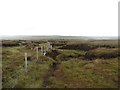
Fence crossing Peat Hags to the East of Lovely Seat
by Chris Heaton geograph for square SD8895 A procession across a hopeless terrain of hags, groughs and bogs.
|
|
Peat hags on Hirstane Rig
by Iain Russell geograph for square NS9306 The hags were numerous and deep throughout this stretch of moorland. The upper... (more)
|
|
Peat hags on Hunt Hill
by Alan O'Dowd geograph for square NO3880 A few small scraps of snow were clinging on in the hollows.
|
|
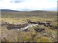
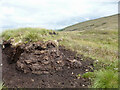
Peat hag, Shannach Moss
by Dorothy Carse geograph for square NJ2915 The straight edges suggest peat has been cut for fuel here.
|
|
More peat hags
by Richard Law geograph for square NH0324 The lower ground in Gleann Gaorsaic is hard going, across extensive eroding peat... (more)
|
|
Peat hags & bogwood
by Richard Law geograph for square NH0320 There must, once, have been a substantial piece of the Caledonian Pinewood here... (more)
|
|
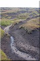
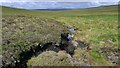
Peat hag
by Richard Webb geograph for square NT1629 An eroded channel in peat deposits north of Long Grain Knowe. Frost made the... (more)
|
|
Peat hag, Ben Earb
by Jim Barton geograph for square NO0768 The edge of an eroded bank of peat around 1 m deep S of the summit. Looking W... (more)
|
|
Eroding peat, Finbracks
by Richard Webb geograph for square NO3970 Peat hags on Finbracks.
|
|
Peat hags, Carn na Cloiche
by Jim Barton geograph for square NJ0821 Eroded peat at about 650m on the flat ground near a col SW of Carn na Cloiche,... (more)
|
|
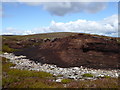
Peat hags, Hill of Badymicks
by Bill Harrison geograph for square NO5885 Peat has completely eroded away in the foreground to leave fine granite chips.
|
|
Bare peat, Creachan an Fhiodha
by Richard Webb geograph for square NH5082 Peat hag country - I was fortunate to find a grough going my way which eased my progress.
|
|
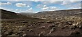
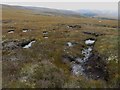
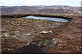
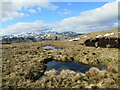
Half-frozen bog pools north-west of Sròn na Maoile
by Alan O'Dowd geograph for square NN6817 Some eroded peat hags are visible on the right, and in the distance, with the... (more)
|
|
Peat hag by the Fèith Ghur, Sutherland
by Claire Pegrum geograph for square NC8037 Ben Loyal can be seen in the centre of the horizon.
|
|
Peat hags near Lochan Creag nan Caorann ('lochan of the rowan crag')
by Alan O'Dowd geograph for square NN3021 The less-frequently visited sides of Ben Oss and Beinn Dubhcraig form the backdrop.
|
|
Peat hags on Auchenlongford Hill
by Alan O'Dowd geograph for square NS5829 As viewed from the flank of Blacksidend.
|
|
Peat hags on Beinn a'Chrulaiste
by Iain Russell geograph for square NN2356 The terrain became a lot more stone strewn further up the hillside.
|
|
Cogill Head Hags
by Chris Heaton geograph for square SD8895 A mass of exposed peat, naked to the sky - unashamed and unabashed!
|
|
Peat hags by Sandsack Burn, Caithness
by Claire Pegrum geograph for square ND0221 Looking towards Blàr a' Ghille Dhomhnaich.
|
|
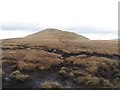
Peat hags on Meall nam Fuaran ('rounded hill of the springs')
by Alan O'Dowd geograph for square NN8236 The summit plateau here is a maze of grassy islands amongst peat bogs - this... (more)
|