|
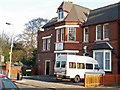
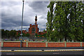
1 Bournbrook Road, Bournbrook, Birmingham
by Phil Champion
geograph for square SP0583
This building was located adjacent to the Bourn Brook, and Bristol Road (A38),... (more)
|
|
Bristol Road, Bournbrook, near the Gun Barrels and Bournbrook Fire Station
by Phil Champion
geograph for square SP0583
This section of the A38 had recently been widened as part of the Selly Oak New... (more)
|
|
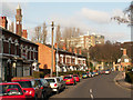
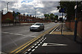
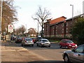
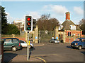
Bournbrook Road, Bournbrook
by Phil Champion
geograph for square SP0583
Looking towards Bristol Road and Birmingham University. Most of these houses are... (more)
|
|
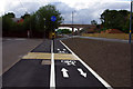
Segregated shared use path near Birmingham University's South Gate, Bournbrook
by Phil Champion
geograph for square SP0483
Approaching the junction the white line delineating the segregated part of the... (more)
|
|
Segregated shared use path and advanced stop line reservoir near Birmingham University's South Gate, Bournbrook
by Phil Champion
geograph for square SP0483
Approaching the junction the white line delineating the segregated part of the... (more)
|

|
Bristol Road, Bournbrook, near Birmingham University's South Gate
by Phil Champion
geograph for square SP0583
This section of the A38 had recently been widened as part of the Selly Oak New... (more)
|
|
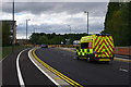
An ambulance speeds along Aston Webb Boulevard, Bournbrook
by Phil Champion
geograph for square SP0483
This section of road had only opened that morning. The road takes pressure off... (more)
|
|
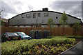
Rear of Rich Bitch Studios, Bournbrook
by Phil Champion
geograph for square SP0483
Many of the older buildings in this area of Bournbrook have been demolished to... (more)
|
|
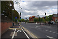
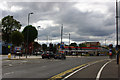
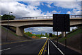
Junction of Bristol Road and Aston Webb Boulevard, Bournbrook
by Phil Champion
geograph for square SP0483
The road swinging to the right is a new relief road (Selly oak New Road Phase... (more)
|
|
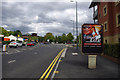
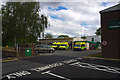
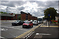
Bournbrook Ambulance Station, Bristol Road
by Phil Champion
geograph for square SP0583
Near the junction with Edgbaston Park Road. To the right is the end of the fire station.
|
|
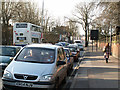
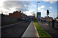
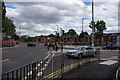
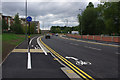
Heavy traffic on Bristol Road, Bournbrook
by Phil Champion
geograph for square SP0583
Looking eastwards from near the University of Birmingham's South Gate. The... (more)
|
|
Heavy traffic on Bristol Road, Bournbrook
by Phil Champion
geograph for square SP0483
Looking west from near the Birmingham University's South Gate. This section... (more)
|
|
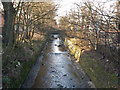
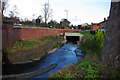
The Bourn Brook, upstream of Bournbrook Road, Bournbrook
by Phil Champion
for square SP0483
This canalised section of river near the campus of the University of Birmingham... (more)
|
|
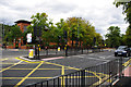
South Gate, Birmingham University
by Phil Champion
geograph for square SP0583
Looking across the busy Bristol Road (A38) from the end of Bournbrook Road. This... (more)
|
|
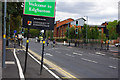
Welcome to Edgbaston - sign on Bristol Road, Bournbrook
by Phil Champion
geograph for square SP0483
But not if you're a cyclist, as the poles supporting the sign obstruct the... (more)
|
|
Aston Webb Boulevard, Bournbrook
by Phil Champion
geograph for square SP0483
Phase 2 of the Selly Oak New Road scheme, this section of relief road had only... (more)
|
|
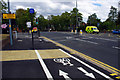
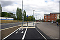
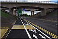
Pedestrian crossing and cycle path - Selly Oak New Road Phase 2 (Aston Webb Boulevard)
by Phil Champion
geograph for square SP0483
The section of road seen here had only opened that morning. This is part of the... (more)
|
|
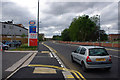
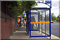
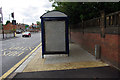
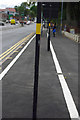
Bus shelter on Bristol Road, Bournbrook
by Phil Champion
for square SP0583
Near Birmingham University's South Gate. Believe it or not this is a shared... (more)
|
|
Bristol Road and Arley Road, Bournbrook
by Phil Champion
geograph for square SP0483
The footways and verge seen here were constructed over the line of the Bourn... (more)
|
|
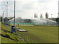
Floodlit sports pitches at the University of Birmingham
by Phil Champion
geograph for square SP0483
The grass pitch in the foreground is the Bournbrook rugby pitch, used for... (more)
|
|
Culvert over the Bourn Brook near Arley Road, Bournbrook
by Phil Champion
geograph for square SP0483
A section of the brook has been culverted to accommodate widening of part of... (more)
|
|
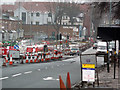
Roadworks on Bristol Road, Bournbrook
by Phil Champion
geograph for square SP0583
Widening works near the Bourn Brook and Arley Road to accommodate a junction... (more)
|
|
Junction of Selly Oak New Road Phase 2 (Aston Webb Boulevard) and Bristol Road, Bournbrook
by Phil Champion
geograph for square SP0483
The new section of road to the left of the photographers position had opened that morning.
|
|
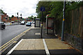
Bus shelter on Bristol Road, Bournbrook
by Phil Champion
geograph for square SP0583
Believe it or not this is a shared use path. The sections north and south have a... (more)
|
|
Shared use path on Bristol Road, Bournbrook
by Phil Champion
geograph for square SP0583
Marked out as an afterthought for cyclists as part of the Selly Oak New Road... (more)
|
|
An obstructed cycle path, Bournbrook
by Phil Champion
geograph for square SP0583
The cycle part of this two-way segregated shared use path along Bristol Road is... (more)
|
|
Segregated shared use path and advanced stop line near the Gun Barrels pub, Bournbrook
by Phil Champion
geograph for square SP0583
The wide footway on this section of Bristol Road had recently been converted to... (more)
|
|
Segregated shared use path and advanced stop line near the Gun Barrels pub, Bournbrook
by Phil Champion
geograph for square SP0583
The wide footway on this section of Bristol Road had recently been converted to... (more)
|
|
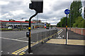
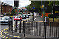
Pedestrian railings at the junction of Bristol Road and Edgbaston Park Road, Bournbrook
by Phil Champion
geograph for square SP0583
Near the Gun Barrels public house.
Note the freshly painted two way... (more)
|
|
Pedestrian crossings and box junction on Bristol Road, Bournbrook
by Phil Champion
geograph for square SP0583
At the junction with Edgbaston Park Road.
|
|
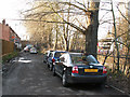
Arley Road, Bournbrook, Birmingham
by Phil Champion
geograph for square SP0483
An unadopted street next to the Bourn Brook. Bristol Road (A38) is on the other... (more)
|
|
Shared use path alongside Aston Webb Boulevard and Dale Road
by Phil Champion
geograph for square SP0483
Approaching the 'piazza' at the end of Grange Road and the gates into... (more)
|
|
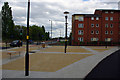
The 'piazza' between Grange Road and Selly Oak New Road
by Phil Champion
geograph for square SP0483
This area of paving was installed as part of a new relief road.
From the... (more)
|
|
Sports pitches at Birmingham University
by Phil Champion
geograph for square SP0483
Sports pitches at Birmingham University.
|
|
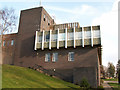
Medical Physics building, University of Birmingham
by Phil Champion
geograph for square SP0483
A 1960s building on Ring Road South.
|
|
Ariel Aqueduct - Aston Webb Boulevard (Selly Oak New Road, Phase 2)
by Phil Champion
geograph for square SP0483
This new relief road had only opened a few hours earlier. I don't expect... (more)
|
|
Segregated shared use path alongside Aston Webb Boulevard (Selly Oak New Road, Phase 2)
by Phil Champion
geograph for square SP0483
Looking towards the new canal and railway bridges.
|
|
Cycle path alongside Dale Road and Aston Web Boulevard (Selly Oak New Road, Phase 2)
by Phil Champion
geograph for square SP0483
The new relief road had opened that morning.
|
|
Shared use path alongside Aston Webb Boulevard (Selly Oak New Road- Phase 2)
by Phil Champion
geograph for square SP0483
The new relief road had only opened that morning.
|
|
South side of the Aston Webb building, University of Birmingham
by Phil Champion
geograph for square SP0483
The part straight ahead is Aston Webb Block C (R7), with the Great Hall to the... (more)
|