Public Tags
Other tags: Churchill
Showing images tagged with place:Churchill tag.
|
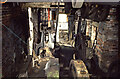
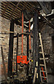
Churchill Forge
by Chris Allen for square SO8879 Churchill Forge water mill was one of the last working water powered forge mills... (more)
|
|
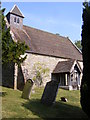
Churchill Church
by Gordon Griffiths for square SO9253 The view of St Michael Church in the village of Churchill.
|
|
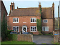
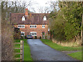
Churchill Farm, Churchill
by Chris Allen geograph for square SO9253 The farmhouse is Listed Grade II.
Tags:
place:Churchill
subject:FarmX
top:Farm, Fishery, Market GardeningX
type:GeographX
Grade II Listed BuildingX
top:Historic Sites and ArtefactsX
county:WorcestershireX
|
|
Churchill Farmhouse, Churchill
by Chris Allen geograph for square SO9253 Grade II Listed. The closest part with the blind window is late 18th century and... (more)
Tags:
place:Churchill
top:Farm, Fishery, Market GardeningX
subject:FarmhouseX
type:GeographX
top:Historic Sites and ArtefactsX
top:Housing, DwellingsX
county:WorcestershireX
|
|
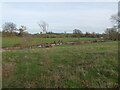
Bow Brook, Churchill
by Chris Allen geograph for square SO9253 From the footpath near Churchill Mill
|
|
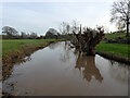
Bow Brook, Churchill
by Chris Allen geograph for square SO9253 This brook near Churchill Mill looks to be very full and there is evidence of... (more)
|
|
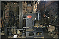
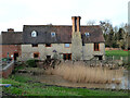
Churchill Forge
by Chris Allen for square SO8879 Churchill Forge water mill was one of the last working water powered forge mills... (more)
Tags:
place:Churchill
ForgeX
top:Historic Sites and ArtefactsX
type:InsideX
subject:MachineX
Machine ToolsX
Water PowerX
top:Water ResourcesX
|
|
Churchill Forge
by Chris Allen for square SO8879 Churchill Forge water mill was one of the last working water powered forge mills... (more)
Tags:
place:Churchill
ForgeX
top:Historic Sites and ArtefactsX
type:InsideX
subject:MachineryX
Water PowerX
top:Water ResourcesX
|
|
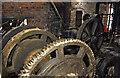
Churchill Forge - drop stamp
by Chris Allen for square SO8879 Churchill Forge water mill was one of the last working water powered forge mills... (more)
Tags:
place:Churchill
ForgeX
Forging HammerX
top:Historic Sites and ArtefactsX
type:InsideX
subject:MachineX
Water PowerX
top:Water ResourcesX
|
|
Churchill Forge
by Chris Allen geograph for square SO8879 Churchill Forge water mill was one of the last working water powered forge mills... (more)
Tags:
place:Churchill
subject:ForgeX
type:GeographX
top:Historic Sites and ArtefactsX
Water PowerX
top:Water ResourcesX
WaterwheelX
|
|
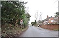
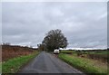
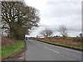
Lane View
by Gordon Griffiths geograph for square SO8879 The view along Churchill Lane in Churchill, Worcestershire.
|
|
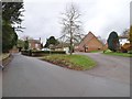
Churchill Scene
by Gordon Griffiths geograph for square SO8779 The village scene by the church in Churchill, Worcestershire.
Tags:
place:Churchill
type:GeographX
subject:VillageX
Village CentreX
top:Village, Rural SettlementX
county:WorcestershireX
|
|
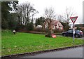
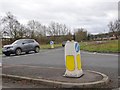
Churchill Cenotaph
by Gordon Griffiths geograph for square SO8879 The view of the Stakenbridge Lane junction in Churchill.
Tags:
CenotaphX
place:Churchill
type:GeographX
LaneX
Road JunctionX
top:Village, Rural SettlementX
subject:War MemorialX
county:WorcestershireX
|
|
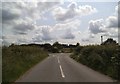
Axborough Lane Junction
by Gordon Griffiths geograph for square SO8679 A narrow lane joins the A451 near Churchill, Worcestershire.
Tags:
place:Churchill
Narrow Country LaneX
Road JunctionX
top:Roads, Road TransportX
county:WorcestershireX
|
|
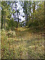
Woodland Path
by Gordon Griffiths geograph for square SO9153 The view of the path through Marshes Wood near Churchill.
|
|
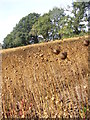
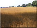
Strange Crop detail
by Gordon Griffiths for square SO9153 The detail view of the field crop next to the Marshes Wood near Churchill. The... (more)
|
|
Strange Crop
by Gordon Griffiths geograph for square SO9153 The view of the field next to the Marshes Wood near Churchill. The seed crop is... (more)
|
|
Moat View
by Gordon Griffiths geograph for square SO9253 The view of the Moat bank at Churchill village.
|
|
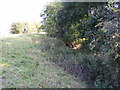
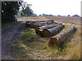
Felled Trees
by Gordon Griffiths geograph for square SO9154 The view alongside the footpath near Churchill Wood.
|
|
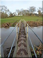
Footbridge over Bow Brook, Churchill
by Chris Allen geograph for square SO9253 Tags:
subject:BridgeX
BrookX
place:Churchill
FootbridgeX
type:GeographX
top:PathsX
Public FootpathX
top:Rivers, Streams, DrainageX
county:WorcestershireX
|
|
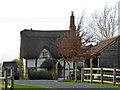
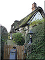
Cobweb Cottage, Churchill
by Chris Allen geograph for square SO9253 A 17th century timber framed, thatched cottage that is Listed Grade II.
Tags:
place:Churchill
subject:CottageX
type:GeographX
Grade II Listed BuildingX
top:Historic Sites and ArtefactsX
top:Housing, DwellingsX
top:Village, Rural SettlementX
county:WorcestershireX
|
|
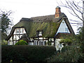
Cobweb Cottage, Churchill
by Chris Allen geograph for square SO9253 A 17th century timber framed, thatched cottage with eyebrow dormer. Listed Grade II.
Tags:
place:Churchill
subject:CottageX
type:GeographX
Grade II Listed BuildingX
top:Historic Sites and ArtefactsX
top:Housing, DwellingsX
top:Village, Rural SettlementX
county:WorcestershireX
|
|
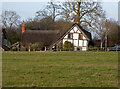
Upper Townsend Farmhouse, Churchill
by Chris Allen geograph for square SO9253 A 16th and 17th century timber framed farmhouse that is Listed Grade II.
Tags:
place:Churchill
top:Farm, Fishery, Market GardeningX
subject:FarmhouseX
type:GeographX
Grade II Listed BuildingX
top:Historic Sites and ArtefactsX
top:Housing, DwellingsX
top:Village, Rural SettlementX
county:WorcestershireX
|
|
Upper Townsend Farmhouse, Churchill
by Chris Allen geograph for square SO9253 A 16th and 17th century timber framed farmhouse that is Listed Grade II.
Tags:
place:Churchill
top:Farm, Fishery, Market GardeningX
subject:FarmhouseX
type:GeographX
Grade II Listed BuildingX
top:Historic Sites and ArtefactsX
top:Housing, DwellingsX
county:WorcestershireX
|
|
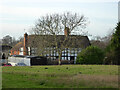
Hunters Hill, Churchill
by Chris Allen geograph for square SO9253 A late 16th century timber framed, thatched house that is Listed Grade II. the... (more)
Tags:
place:Churchill
type:GeographX
Grade II Listed BuildingX
top:Historic Sites and ArtefactsX
subject:HouseX
top:Housing, DwellingsX
top:Village, Rural SettlementX
county:WorcestershireX
|
|
Hunters Hill, Churchill
by Chris Allen geograph for square SO9253 Late 16th century timber framed, thatched house that is Grade II Listed. The... (more)
Tags:
place:Churchill
type:GeographX
Grade II Listed BuildingX
top:Historic Sites and ArtefactsX
subject:HouseX
top:Housing, DwellingsX
top:Village, Rural SettlementX
county:WorcestershireX
|
|
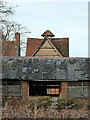
Pigeoncote at Churchill Wood Farm, Worcestershire
by Chris Allen for square SO9154 A 17th century Grade II Listed square pigeocote.
Tags:
place:Churchill
type:Close LookX
subject:DovecoteX
top:Farm, Fishery, Market GardeningX
Grade II Listed BuildingX
top:Historic Sites and ArtefactsX
PigeoncoteX
county:WorcestershireX
|
|
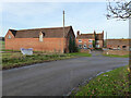
Churchill Wood Farm, Worcestershire
by Chris Allen geograph for square SO9154 Seen from across the A422.
Tags:
place:Churchill
subject:FarmX
top:Farm, Fishery, Market GardeningX
type:GeographX
top:Village, Rural SettlementX
county:WorcestershireX
|
|
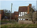
Churchill Wood Farmhouse, Worcestershire
by Chris Allen geograph for square SO9154 A Grade II Listed late 17th century farmhouse. Seen from across the A422 road.
Tags:
place:Churchill
top:Farm, Fishery, Market GardeningX
subject:FarmhouseX
type:GeographX
Grade II Listed BuildingX
top:Historic Sites and ArtefactsX
top:Housing, DwellingsX
county:WorcestershireX
|
|
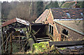
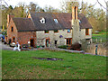
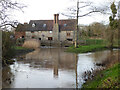
Churchill Mill, Worcestershire
by Chris Allen geograph for square SO9253 Former watermill that is now a dwelling and Listed Grade II.
Tags:
place:Churchill
type:GeographX
top:Historic Sites and ArtefactsX
top:Housing, DwellingsX
subject:MillX
top:Water ResourcesX
former:WatermillX
county:WorcestershireX
|
|
Churchill Mill, Worcestershire
by Chris Allen geograph for square SO9253 A Grade II Listed former watermill that is now a dwelling. This incarnation is... (more)
Tags:
place:Churchill
type:GeographX
top:Historic Sites and ArtefactsX
top:Housing, DwellingsX
subject:MillX
top:Water ResourcesX
former:WatermillX
county:WorcestershireX
|
|
Churchill Mill, Worcestershire
by Chris Allen geograph for square SO9253 Former watermill that is now a house. The current incarnation is 18th century... (more)
Tags:
place:Churchill
type:GeographX
top:Historic Sites and ArtefactsX
top:Housing, DwellingsX
subject:MillX
top:Water ResourcesX
former:WatermillX
county:WorcestershireX
|
|
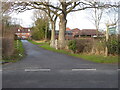
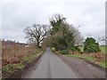
Crown Lane
by Gordon Griffiths geograph for square SO8880 The view up the lane towards Common Farm near Churchill, Worcestershire.
|
|
Crown Lane View
by Gordon Griffiths geograph for square SO8880 The view up the lane towards Common Farm near Churchill, Worcestershire.
|
|
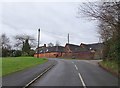
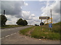
Waggon Lane Junction
by Gordon Griffiths geograph for square SO8779 The view from Church Lane in Churchill, Worcestershire.
Tags:
place:Churchill
type:GeographX
subject:Lane JunctionX
Village CentreX
top:Village, Rural SettlementX
county:WorcestershireX
|
|
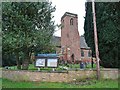
St James View
by Gordon Griffiths geograph for square SO8779 The church of St James the Great in Churchill, Worcestershire.
Tags:
subject:ChurchX
ChurchX
place:Churchill
type:GeographX
top:Religious SitesX
Village ChurchX
county:WorcestershireX
|
|
Stakenbridge Lane
by Gordon Griffiths geograph for square SO8780 The view near Five Ways junction off the Stourbridge Road(A451) near Churchill.
|
|
Junction Scene
by Gordon Griffiths geograph for square SO8780 The Five Ways junction on the Stourbridge Road(A451) near Churchill.
Tags:
place:Churchill
type:GeographX
subject:Road JunctionX
Road JunctionX
top:Roads, Road TransportX
county:WorcestershireX
|
|
Axborough Lane Junction View
by Gordon Griffiths geograph for square SO8679 A narrow lane joins the Stourbridge Road (A451) near Churchill, Worcestershire.
Tags:
A Road (Classified A)X
place:Churchill
Narrow Country LaneX
Road JunctionX
top:Roads, Road TransportX
county:WorcestershireX
|
|
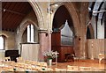
St Thomas, Telford Avenue, Telford Park - Organ
by John Salmon for square TQ2973 |
|
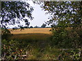
Out of the Wood
by Gordon Griffiths geograph for square SO9153 The view from the Marshes Wood near Sneachill.
|