|
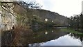
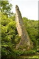
Water-cum-Jolly Dale, Derbyshire
by Andrew Tryon
geograph for square SK1772
Limestone crags next to the River Wye in the idyllic and intriguingly named... (more)
|
|
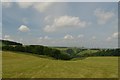
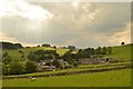
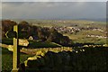
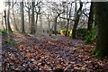
Hills above Dove Dale near Alsop, Derbyshire
by Andrew Tryon
geograph for square SK1555
View facing west down towards Dove Dale, Derbyshire. The county boundary... (more)
|
|
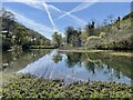
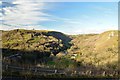
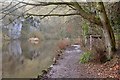
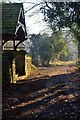
River Wye near Miller's Dale
by Dave Pickersgill
for square SK1672
|
|
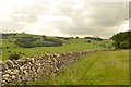
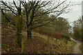
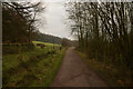
Public Footpath and Limestone Wall near Alsop, Derbyshire
by Andrew Tryon
geograph for square SK1654
View along the public footpath from Parwich to Alsop en le Dale in Derbyshire, England.
|
|
Eastern Prospect of Alsop en le Dale, Derbyshire
by Andrew Tryon
geograph for square SK1655
A view of the small settlement of Alsop en le Dale as seen when approaching on... (more)
|
|
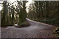
Hairpin Bend at Cressbrook Dale, Derbyshire
by Andrew Tryon
geograph for square SK1773
A view from the apex of a hairpin bend on the steep hillside of Cressbrook Dale.
|
|
Following the Limestone Way
by Andrew Tryon
geograph for square SK2163
|
|
Monsal Head, Derbyshire
by Andrew Tryon
geograph for square SK1871
View of Monsal Dale from Monsal Head, Derbyshire. Monsal Head is a popular Peak... (more)
|

|
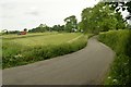
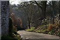
Driveway near Parwich, Derbyshire
by Andrew Tryon
geograph for square SK1754
This pleasant tree lined road in rural Derbyshire is a private driveway serving... (more)
|
|
Riverside Path in Water-cum-Jolly Dale, Derbyshire
by Andrew Tryon
geograph for square SK1672
This riverside path can be under water when the adjacent river Wye is high.
|
|
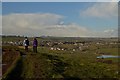
Public Footpath Crossings near Youlgreave, Derbyshire
by Andrew Tryon
geograph for square SK2162
A crossroads of public footpaths in the hills south of Youlgreave in the White... (more)
|
|
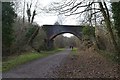
The Monsal Trail, Derbyshire
by Andrew Tryon
geograph for square SK1572
|
|
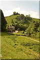
Dovedale, Derbyshire
by Andrew Tryon
geograph for square SK1455
The valley of the River Dove. The River Dove at this location forms the... (more)
|
|
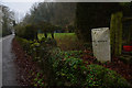
Roadside Boundary Stone in Derbyshire, UK
by Andrew Tryon
geograph for square SK2553
A stone marking the boundary between the villages of Carsington and Hopton in... (more)
|
|
Sunshine and Frost at Hay Woods, Derbyshire
by Andrew Tryon
geograph for square SK2578
Pale winter sunshine illuminates the woodland air at Nether Padley in the... (more)
|
|
Carved Wooden trunk next to the Footpath, Carsington Water, Derbyshire
by Andrew Tryon
geograph for square SK2551
A carved wooden trunk of an old tree, which almost blends into the undergrowth,... (more)
|
|
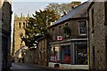
Youlgreave Main Street, Derbyshire
by Andrew Tryon
geograph for square SK2164
View along the main street in the village of Youlgreave, Derbyshire. The church... (more)
|
|
Ilam Rock in Dovedale, Staffordshire
by Andrew Tryon
for square SK1453
Ilam Rock is a limestone pinnacle within Dovedale, Staffordshire. The river... (more)
|
|
Washbrook Lane, Tissington, Derbyshire
by Andrew Tryon
geograph for square SK1651
A view of Washbrook Lane and adjacent farmland as seen from the point where... (more)
|
|
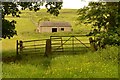
Country Barn near Thorpe, Derbyshire
by Andrew Tryon
geograph for square SK1650
View from the Limestone Way (long distance footpath) near the village of Thorpe,... (more)
|
|
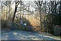
Parish Boundary of Tissington and Parwich, Derbyshire
by Andrew Tryon
geograph for square SK1853
Walkers following the Limestone Way (long distance path) will encounter this... (more)
|
|
Parwich, Derbyshire
by Andrew Tryon
geograph for square SK1854
Tourists seeking a quiet and unspoiled Peak District village could do worse than... (more)
|
|
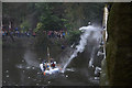
Flour Fight at Matlock, Derbyshire, Great Britain
by Andrew Tryon
geograph for square SK2958
In Great Britain, there is a custom among some people to participate in slightly... (more)
|
|
Dudwood Lane, Derbyshire
by Andrew Tryon
geograph for square SK2261
Dudwood Lane is a minor road near to the Peak District villages of Elton and... (more)
|
|
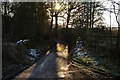
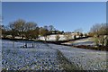
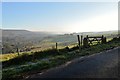
Public Footpath from Winster to Westhill, Derbyshire
by Andrew Tryon
geograph for square SK2360
Snow in the fields to the west of Winster village, Derbyshire.
|
|
The Perimeter Trail at Carsington Reservoir, Derbyshire, UK
by Andrew Tryon
geograph for square SK2552
Part of the well made recreational trail which circumnavigates Carsington Water... (more)
|
|
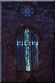
Illuminated Cross in Church Window, Wirksworth, Derbyshire
by Andrew Tryon
for square SK2854
An illuminated cross at Christmas, set within the south window of a church... (more)
|

|
Winster Church 2017 Christmas Tree Festival, Derbyshire
by Andrew Tryon
for square SK2360
A selection of Christmas trees from the local community on display inside the... (more)
|
|
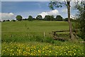
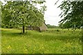
Rural Scene near Tissington, Derbyshire
by Andrew Tryon
geograph for square SK1751
Meadow flowers and a stone barn just off the Avenue in Tissington.
|
|
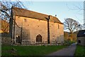
Padley Chapel, Derbyshire
by Andrew Tryon
geograph for square SK2478
|
|
Winter in Hay Wood, Derbyshire
by Andrew Tryon
geograph for square SK2577
|
|
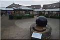
The Kugel Stone at Carsington Visitor Centre, Derbyshire, UK
by Andrew Tryon
geograph for square SK2451
This spherical lump of polished granite, weighing around one ton, is not in... (more)
|
|
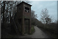
Disused WWII Lookout on the Perimeter Path of Carsington Reservoir, Derbyshire, UK
by Andrew Tryon
geograph for square SK2452
This disused brick built structure, standing beside the perimeter footpath of... (more)
|
|
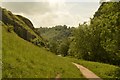
Public Footpath in Dovedale, Derbyshire
by Andrew Tryon
geograph for square SK1354
The limestone valley of Dovedale is a famous Peak District beauty spot.
|
|
Lych Gate and Lane at Stoney Middleton, Derbyshire
by Andrew Tryon
geograph for square SK2375
A lych gate is a covered gateway at the entrance to a churchyard or burial... (more)
|
|
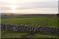
Typical White Peak Stile near Tideswell, Derbyshire
by Andrew Tryon
geograph for square SK1475
These dry stone walls and stiles are classic scenery of the White Peak, a... (more)
|
|
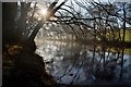
River Derwent, Derbyshire
by Andrew Tryon
geograph for square SK2475
|
|
Derwent Valley from the Eyam Road, Derbyshire
by Andrew Tryon
geograph for square SK2376
View over the Derwent Valley from the closed B6521 Eyam to Grindleford road.
|
|
Hollywell Lane, Youlgreave, Derbyshire
by Andrew Tryon
geograph for square SK2064
Hollywell Lane runs from the village of Youlgreave down to the River Bradford.... (more)
|
|
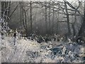
Frosty Grass at the Haywood, Nether Padley, Derbyshire
by Andrew Tryon
geograph for square SK2477
|
|
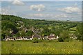
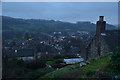
View over Wirksworth, Derbyshire, Great Britain
by Andrew Tryon
geograph for square SK2854
View over the small town of Wirksworth on a gloomy winter evening.
|
|
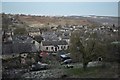
Winster, Derbyshire
by Andrew Tryon
geograph for square SK2460
View over the village of Winster from East Bank. Winster is a small village... (more)
|
|
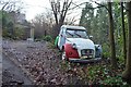
An Old Citroen Dolly at Nether Padley, Derbyshire
by Andrew Tryon
geograph for square SK2578
This old car lying next to Tedgness Road doesn't appear to be roadworthy.
|
|
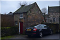
Small House and Car in Wirksworth, Great Britain
by Andrew Tryon
geograph for square SK2853
|