|
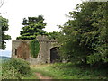
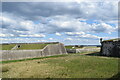
Rodborough Fort corner - Stroud, Gloucestershire
by Martin Richard Phelan
geograph for square SO8404
Standing on Rodborough Common, high above Stroud and its meeting of five... (more)
|
|
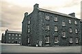
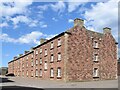
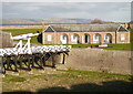
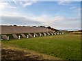
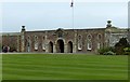
The Barracks at Fort George - July 1993
by Jeff Buck
geograph for square NH7656
The barracks in the 18th-century fortress of Fort George.
Wikipedia:... (more)
|
|
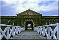
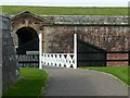
The Main Entrance to Fort George - July 1993
by Jeff Buck
geograph for square NH7656
Entrance to the 18th-century fortress of Fort George.
Wikipedia:... (more)
|
|
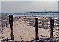
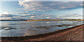
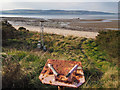
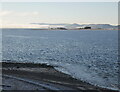
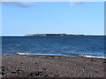
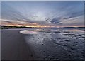
Beach below Fort George
by valenta
for square NH7556
Old weathered railway sleepers below Fort George, looking across to Chanonry... (more)
|
|
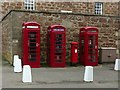
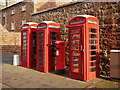
Fort George, K6 telephone kiosks
by Alan Murray-Rust
for square NH7656
Not quite identical triplets, but you have to look carefully! Listed Category B... (more)
|
|
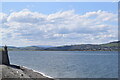
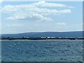
Fort George: looking towards Fortrose
by Bill Harrison
for square NH7656
Fortrose is just a couple of kilometres across the Moray Firth from Fort George... (more)
|
|
Fort George
by valenta
geograph for square NH7656
Beach below the north side of Fort George
|
|
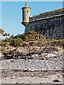
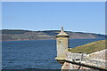
Bartizan Fort George
by valenta
geograph for square NH7656
Bartizan turret on the north wall of Fort George
|
|
Fort George
by valenta
geograph for square NH7556
Panoramic view of the eastern end of Fort George taken at low tide
|
|
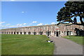
Fort George: north barrack block
by Bill Harrison
geograph for square NH7656
Fort George is still (in 2022) an active army base and soldiers still occupy the... (more)
|
|
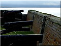
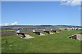
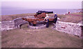
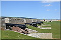
The guns of Fort George
by Alan Murray-Rust
for square NH7556
Looking south from the western bulwark.
|
|
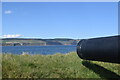
Beach on the edge of the Fort George Range
by valenta
geograph for square NH7957
Looking across towards Whiteness Head, just on the edge of the Fort George... (more)
|
|
Lookout post on Fort George Coastline
by valenta
geograph for square NH7757
A CCTV camera monitors the offshore Fort George danger zone. The rusty stand in... (more)
|
|
Ravelin Guardhouse and Drawbridge, Fort George
by Craig Wallace
geograph for square NH7656
The main entrance to Fort George, with a bridge across the moat. The guard house... (more)
|
|
Fort George Obstacle Course
by valenta
geograph for square NH7957
Fort George MOD Army Confidence Course
|
|
Drawbridge, Fort George
by Craig Wallace
geograph for square NH7656
The main entrance from the ravelin into the fort.
|
|
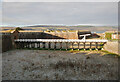
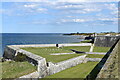
Beach, by Fort George
by Craig Wallace
geograph for square NH7556
A view from the ramparts, at the western tip of the fort. Looking towards Chanonry Point.
|
|
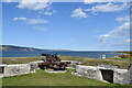
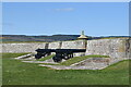
Cannons, Fort George
by Craig Wallace
geograph for square NH7556
On the ramparts, at the western end of the fort.
|
|
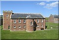
Fort George: the garrison chapel
by Bill Harrison
geograph for square NH7656
The chapel was the last building to be completed in 1767. The whole fort is... (more)
|
|
Fort George: western ramparts and the point battery
by Bill Harrison
geograph for square NH7556
The Black Isle is in the distance on the other side of the Moray Firth.
|
|
Fort George: watchtower over the Moray Firth...
by Bill Harrison
geograph for square NH7656
...with the Black Isle in the distance.
|
|
Fort George: under the gun
by Bill Harrison
for square NH7656
|
|
Fort George: guarding the approach to Inverness
by Bill Harrison
geograph for square NH7656
As the Jacobite threat receded, the fort was repurposed for coastal defence of... (more)
|
|
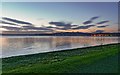
Looking towards Fort George
by Bill Harrison
geograph for square NH7555
The fort is just over a kilometre across the Moray Firth but a good 50 km by... (more)
|
|
Evening sky over the beach at Carse of Ardersier
by valenta
geograph for square NH7957
An area popular with local dog walkers, the bay is shallow and drains out during... (more)
|
|
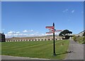
Fort George entrance
by Alan Murray-Rust
for square NH7656
The gateway through the Ravelin wall, the first stage of the fort's entry defences.
|
|
Fort George Rifle Range
by valenta
geograph for square NH7657
Access through the range is possible when the red flag is not flying, denoting... (more)
|
|
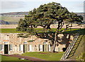
Spruce tree, Fort George
by Craig Wallace
geograph for square NH7656
A large tree growing in the corner of the fort.
|
|
Ardersier Bay Sunset
by valenta
geograph for square NH7755
Looking over the bay to The Black Isle, and the lights of Fort George on the right
|
|
Telephone boxes and postbox, Fort George
by Craig Wallace
for square NH7656
The three K6 telephone boxes are Category B listed.... (more)
|
|
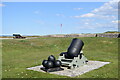
A unique gun, Fort George
by Richard Sutcliffe
geograph for square NH7656
The only surviving example of a MK1 RML 64 pounder 64 cwt gun... (more)
|
|
Fort George
by Alan Murray-Rust
for square NH7656
Seen across the Moray Firth from below Scart Craig.
|
|
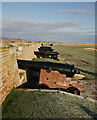
Fort George: the main ditch
by Bill Harrison
geograph for square NH7656
Part of the ravelin (forward defensive position) can be seen to the left.
|
|
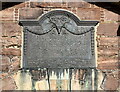
We shall remember...
by Bill Harrison
for square NH7656
Memorial plaque over the main gateway at Fort George to the 8432 Seaforth... (more)
|
|
Fort George: the main gateway
by Bill Harrison
geograph for square NH7656
The causeway over the ditch can just be seen through the arch.
|

|
Fort George: barrack block windows
by Bill Harrison
for square NH7656
Also showing original stonework and patched areas.
|
|
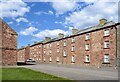
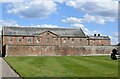
Fort George: south barrack block
by Bill Harrison
geograph for square NH7656
|
|
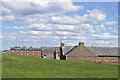
Fort George: the ordnance store
by Bill Harrison
geograph for square NH7656
|
|
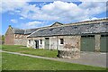
Fort George: the stable block
by Bill Harrison
geograph for square NH7656
|
|
Fort George: view of the garrison chapel from the south
by Bill Harrison
geograph for square NH7656
|
|
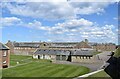
Fort George: general view
by Bill Harrison
geograph for square NH7656
View from the west rampart showing the stables and the provision store and... (more)
|
|
Fort George: the point battery
by Bill Harrison
geograph for square NH7556
|
|
Fort George: buildings
by Bill Harrison
geograph for square NH7656
Nearest to the camera, the provision store, and farther back part of a barrack block.
|
|
Fort George: the pet cemetery
by Bill Harrison
geograph for square NH7656
The northern ravelin now put to an more peaceful purpose.
|
|
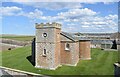
Fort George: the northern ramparts
by Bill Harrison
geograph for square NH7656
The roof of one of the distinctive watchtowers is just visible.
|
|
Fort George: the Duke of Cumberland's bastion
by Bill Harrison
geograph for square NH7656
A siege mortar in the foreground and in the left background a 'very... (more)
|
|
Fort George: the casemates
by Bill Harrison
geograph for square NH7656
An information sign describes these as 'casemated barrack rooms providing... (more)
|
|
Fort George: the parade ground
by Bill Harrison
geograph for square NH7656
The grassy expanse just inside the main entrance.
|
|
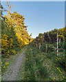
Carse Wood
by valenta
geograph for square NH7956
Path in Carse Wood, the fence and pole marking the boundary of the Fort George... (more)
|
|
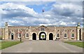
Fort George, main entrance with guardrooms
by Alan Murray-Rust
geograph for square NH7656
This was completed in 1756.
|