Public Tags
Showing images tagged with place:Hawick tag.
|
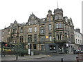
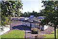
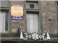
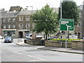
Liberal Club for sale, Hawick
by M J Richardson geograph for square NT5014 On the corner of High Street and Brougham Place. A memorial stone above the grey... (more)
Tags:
subject:BuildingX
Building at RiskX
top:City, Town CentreX
Empty BuildingX
For Sale SignX
type:GeographX
place:Hawick
Liberal ClubX
top:LowlandsX
top:Roads, Road TransportX
place:Scottish BordersX
|
|
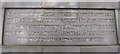
Equestrian Statue, Hawick
by M J Richardson for square NT5014 Details of the unveiling of the statue NT5014 : Equestrian Statue, Hawick:-
Unveiled by Lady Sybil... (more)
Tags:
top:City, Town CentreX
type:Close LookX
place:Hawick
top:LowlandsX
top:People, EventsX
place:Scottish BordersX
subject:SculptureX
person:W.F BeattieX
|
|
Equestrian statue, Hawick
by M J Richardson for square NT5014 Details of the statue NT5014 : Equestrian Statue, Hawick, which was:-
Erected to commemorate the... (more)
Tags:
1514X
Battle of FloddenX
top:City, Town CentreX
type:Close LookX
place:Hawick
top:LowlandsX
top:People, EventsX
place:Scottish BordersX
subject:StatueX
|
|
Hugh MacLeod Place, Hawick
by Richard Dorrell geograph for square NT5015 Housing close to the northern edge of Hawick.
|
|
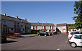
Wilton Primary School, Hawick
by Richard Dorrell geograph for square NT5015 Located in Wellfield Road, Hawick. This building opened in 1974. The school has... (more)
|
|
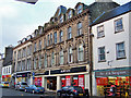
Former Hawick Co-operative Store
by Richard Dorrell geograph for square NT5014 Category: Shop This substantial building stands on the west side of the High Street. It was... (more)
|
|
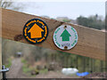
Waymarks near Vertish Hill, Hawick
by Jim Barton for square NT4913 Nan Lyle (1929 - 2010) has been commemorated by a walk to a cairn on... (more)
|
|
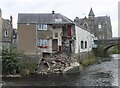
Flood-damaged building, Hawick
by Jim Barton geograph for square NT5014 The building collapsed in flooding in February 2020 when the swollen River... (more)
Tags:
top:City, Town CentreX
Flood Damaged BuildingX
type:GeographX
place:Hawick
top:Housing, DwellingsX
top:Rivers, Streams, DrainageX
river:TeviotX
|
|
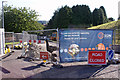
For Sale Notice, Hawick
by M J Richardson for square NT5014 The auction was clearly unsuccessful - this 'building at risk' still... (more)
Tags:
subject:BuildingX
Building at RiskX
top:City, Town CentreX
type:Close LookX
For Sale SignX
place:Hawick
Liberal ClubX
top:LowlandsX
place:Scottish BordersX
|
|
Hawick: Orrock Place
by Jonathan Hutchins geograph for square NT5014 This handsome building bears a sign 'Martinshouse Equestrian'. The... (more)
|
|
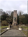
Hawick: war memorial in Wilton Lodge Park
by Jonathan Hutchins geograph for square NT4914 Tags:
place:Hawick
top:Historic Sites and ArtefactsX
subject:MemorialX
top:Park and Public GardensX
War MemorialX
|

|
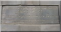
Memorial Stone, Hawick
by M J Richardson for square NT5014 Above the doorway of the empty Liberal Club NT5014 : Liberal Club for sale, Hawick.The Memorial stone... (more)
Tags:
Building at RiskX
top:City, Town CentreX
type:Close LookX
DoorwayX
place:Hawick
Liberal ClubX
top:LowlandsX
subject:MemorialX
top:People, EventsX
place:Scottish BordersX
|
|
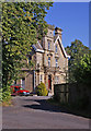
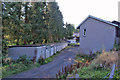
House in Hazelwood Road, Hawick
by Richard Dorrell geograph for square NT5015 This is probably the most substantial house in the immediate vicinity.
|
|
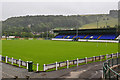
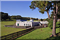
Mansfield Park
by John Allan geograph for square NT5115 The home of Hawick RFC. The grandstand holds 1400 spectators and is the biggest... (more)
Tags:
place:Hawick
top:Sport, LeisureX
|
|
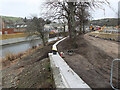
Flood protection and the River Teviot, Hawick
by Jim Barton geograph for square NT5014 The opposite bank has been reinforced with boulders and a wall runs along the... (more)
Tags:
top:City, Town CentreX
top:Construction, DevelopmentX
Flood ProtectionX
type:GeographX
place:Hawick
top:Rivers, Streams, DrainageX
river:TeviotX
|
|
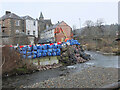
Flood protection work, Hawick
by Jim Barton geograph for square NT5014 Flood protection work in progress at the confluence of the Slitrig Water and the... (more)
Tags:
top:City, Town CentreX
top:Construction, DevelopmentX
Flood ProtectionX
type:GeographX
place:Hawick
top:Rivers, Streams, DrainageX
river:Slitrig WaterX
river:TeviotX
|
|
Flood protection scheme, Hawick
by Jim Barton geograph for square NT5014 The flood protection scheme comprises defenses around the River Teviot and the... (more)
Tags:
top:City, Town CentreX
top:Construction, DevelopmentX
Flood ProtectionX
type:GeographX
place:Hawick
top:Rivers, Streams, DrainageX
river:TeviotX
|
|
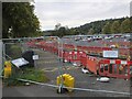
Flood protection works, Hawick
by Jim Barton geograph for square NT5014 Extensive civil engineering works are in progress in the town to install flood... (more)
Tags:
top:City, Town CentreX
top:Construction, DevelopmentX
Flood ProtectionX
type:GeographX
place:Hawick
|
|
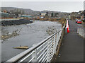
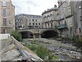
The Slitrig Water, Hawick
by Jim Barton geograph for square NT5014 The Slitrig Water is channelled through the town and meets the River Teviot... (more)
Tags:
top:City, Town CentreX
Former Textile MillX
type:GeographX
place:Hawick
top:Rivers, Streams, DrainageX
river:Slitrig WaterX
|

|
23 Havelock Street, Hawick
by Richard Dorrell geograph for square NT5015 The house on the left is number 23, a former gate lodge, probably designed by... (more)
Tags:
Gate LodgeX
place:Hawick
top:Historic Sites and ArtefactsX
top:Housing, DwellingsX
Listed BuildingX
subject:LodgeX
|
|
Disused garages
by Richard Dorrell geograph for square NT5015 From their appearance, it would seem that few if any of these garages are still... (more)
|

|
Hawick Youth Centre
by Richard Dorrell geograph for square NT5015 Located in Havelock Street.
Tags:
top:City, Town CentreX
subject:ClubX
place:Hawick
top:Public Buildings and SpacesX
Youth CentreX
|
|
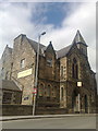
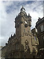
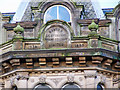
Hawick Town Hall
by Jonathan Hutchins geograph for square NT5014 Built in the Scots baronial style in 1886.
Tags:
subject:BuildingX
top:City, Town CentreX
place:Hawick
top:Public Buildings and SpacesX
building type:Town HallX
|
|
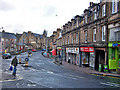
Sandbed Roundabout
by M J Richardson geograph for square NT5014 Where the A7 takes a sharp turn right to leave Hawick.
Tags:
road:A RoadX
A7X
top:Business, Retail, ServicesX
top:City, Town CentreX
place:Hawick
top:Housing, DwellingsX
top:LowlandsX
top:Roads, Road TransportX
Street SceneX
|
|
Inscription on Hawick shop
by Richard Dorrell for square NT5014 Category: Inscription This is the inscription on the large High Street shop currently occupied by... (more)
|
|
Albert Road from Silver Street
by Richard Dorrell geograph for square NT5014 Category: Road scene The gentleman crossing the road is not thinking about the Green Cross Code - not... (more)
|
|
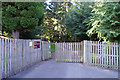
Pedestrian entrance to Wilton Primary School
by Richard Dorrell geograph for square NT5015 Located in Wellfield Road, this suburban school has a very rural-looking... (more)
|
|
Gas main replacement, Stirches Road
by Richard Dorrell geograph for square NT5015 The road is closed to all traffic while a gas main is replaced.
Tags:
top:Construction, DevelopmentX
Gas Main ReplacementX
place:Hawick
subject:RoadX
top:Roads, Road TransportX
|

|
Stirches Primary School
by Richard Dorrell geograph for square NT5015 This is a co-educational, non-denominational school
providing primary education... (more)
|
|
Stirches Primary School
by Richard Dorrell geograph for square NT5015 Stirches Primary School is a co-educational, non-denominational school... (more)
|
|
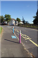
Novelty bollards
by Richard Dorrell geograph for square NT5015 This is the approach road to Stirches Primary School. Similar road markings are... (more)
Tags:
subject:BollardX
top:Educational SitesX
place:Hawick
top:PathsX
Primary SchoolX
top:Roads, Road TransportX
|
|
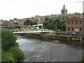
The River Teviot from Albert Bridge
by M J Richardson geograph for square NT5014 Looking from the A7 towards the James Thomson foot and cycle bridge [2005], and... (more)
Tags:
top:City, Town CentreX
place:Hawick
top:Housing, DwellingsX
person:James ThomsonX
top:LowlandsX
top:PathsX
top:Rivers, Streams, DrainageX
river:TeviotX
|