Public Tags
Showing images tagged with place:Higher Wych tag.
|
Higher Wych from Wales
by Jeff Buck geograph for square SJ4943 The village of Higher Wych from across the border in Wales, taken from the... (more)
Tags:
place:Higher Wych
JunctionX
top:Roads, Road TransportX
VillageX
top:Village, Rural SettlementX
country:WalesX
county:WrexhamX
|
|
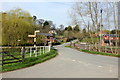
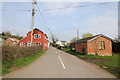
Higher Wych, Cheshire
by Jeff Buck geograph for square SJ4943 Higher Wych Road at Higher Wych. Taken from near the Methodist Church.
|
|
Higher Wych Bridge
by Jeff Buck geograph for square SJ4943 Higher Wych Bridge spanning Wych Brook on the border of England and Wales.
Tags:
subject:BridgeX
BridgeX
county:CheshireX
country:EnglandX
place:Higher Wych
top:Rivers, Streams, DrainageX
Road BridgeX
VillageX
top:Village, Rural SettlementX
|

|
Street furniture in Higher Wych
by Jeff Buck geograph for square SJ4943 Road sign, post box and telephone box on Higher Wych Road.
Tags:
county:CheshireX
country:EnglandX
place:Higher Wych
Post BoxX
Road SignX
Telephone BoxX
VillageX
top:Village, Rural SettlementX
|
|
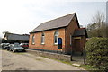
Higher Wych Methodist Church
by Jeff Buck geograph for square SJ4943 Higher Wych Methodist Church/Chapel was built in 1879 and is still used for worship.
Tags:
ChapelX
county:CheshireX
ChurchX
subject:ChurchX
country:EnglandX
place:Higher Wych
Methodist ChurchX
top:Religious SitesX
VillageX
top:Village, Rural SettlementX
|
|
Sandholes Lane at Higher Wych
by Jeff Buck geograph for square SJ4943 Looking east along Sandholes Lane from the junction with Higher Wych... (more)
|
|
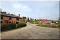
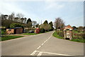
Lane Junction at Higher Wych
by Jeff Buck geograph for square SJ4943 The junction of Higher Wych Road (on the left) and Sandholes Lane (on the right).
Tags:
county:CheshireX
country:EnglandX
place:Higher Wych
JunctionX
top:Roads, Road TransportX
top:Village, Rural SettlementX
|
|
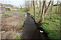
The England/Wales border at Higher Wych
by Jeff Buck geograph for square SJ4943 The national border of England and Wales runs along Wych Brook. England is on... (more)
Tags:
BorderX
BorderlandsX
top:Boundary, BarrierX
BrookX
county:CheshireX
country:EnglandX
boundary:England and WalesX
England/Wales BorderX
place:Higher Wych
National BoundaryX
top:Rivers, Streams, DrainageX
top:Village, Rural SettlementX
country:WalesX
county:WrexhamX
|
|
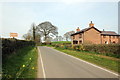
Dodd's Lane heading north
by Jeff Buck geograph for square SJ4943 Dodd's Lane heading north from Higher Wych.
|
|
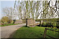
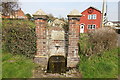
Drinking Fountain at Higher Wych
by Jeff Buck geograph for square SJ4943 The plaque on the fountain was badly worn and not easy to read.
Tags:
county:CheshireX
Drinking FountainX
country:EnglandX
place:Higher Wych
VillageX
subject:VillageX
top:Village, Rural SettlementX
|
|
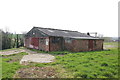
Dilapidated Building at Higher Wych
by Jeff Buck geograph for square SJ4943 This old building or workshop has a small sign with the name WH Smith,... (more)
Tags:
county:CheshireX
top:Derelict, DisusedX
Dilapidated BuildingX
country:EnglandX
place:Higher Wych
top:Village, Rural SettlementX
former:WorkshopX
|