Public Tags
Other tags: near:Hythe End
Showing images tagged with place:Hythe End tag.
|
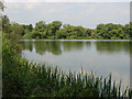
Hythe End gravel pits
by Alan Hunt geograph for square TQ0173 The large area of disused gravel pits to the north of Hythe End, currently a... (more)
|
|
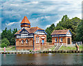
Hythe End Pumping Station
by Jim Osley geograph for square TQ0172 Description at TQ0172 : Part of Hythe Pumping Station.
|
|
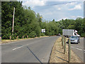
Wraysbury Road
by Alan Hunt geograph for square TQ0172 Wraysbury Road approaching the roundabout with the A30/M25 access road.
Tags:
place:Hythe End
top:Roads, Road TransportX
|
|
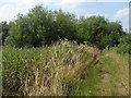
Path along the Colne Brook
by Alan Hunt geograph for square TQ0173 The footpath between the Colne Brook and the disused gravel pits. This area has... (more)
|