Public Tags
Showing images tagged with place:Malpas tag.
|
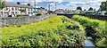
Malpas Brook/Crindau Pill, Newport.
by Robin Drayton for square ST3189 The walls either side were part of the Crindau Flood Scheme that was completed... (more)
Tags:
top:City, Town CentreX
type:Cross GridX
Flood Defence WallX
place:Malpas
place:NewportX
top:Rivers, Streams, DrainageX
|
|
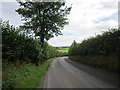
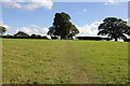
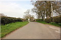
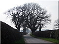
Footpath to Malpas at Wychough
by Jeff Buck geograph for square SJ4845 This footpath skirts around Manor Farm to Mastiff Lane and then on to Malpas.
|
|
Footpath to Malpas
by Jeff Buck geograph for square SJ4846 Public footpath to Malpas from Mastiff Lane.
Tags:
county:CheshireX
country:EnglandX
FootpathX
place:Malpas
place:Oldcastle HeathX
top:PathsX
Public FootpathX
top:Village, Rural SettlementX
|
|
Roman Road to Malpas
by Jeff Buck geograph for square SJ4848 The old Tilston to Malpas Roman road, now the Tilston Road heading south towards Malpas.
Tags:
county:CheshireX
country:EnglandX
place:Malpas
RoadX
top:Roads, Road TransportX
Roman RoadX
top:Village, Rural SettlementX
|
|
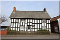
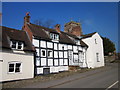
Timbered framed building in Malpas
by Jeff Buck geograph for square SJ4847 A timbered framed building, possibly 17th century on Old Hall Street, Malpas.... (more)
Tags:
county:CheshireX
country:EnglandX
top:Historic Sites and ArtefactsX
top:Housing, DwellingsX
place:Malpas
Timber FramedX
Timber Framed BuildingX
Timbered Framed HouseX
top:Village, Rural SettlementX
|
|
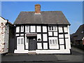
The Nest, Malpas
by Jeff Buck geograph for square SJ4847 The Nest in Old Hall Street, Malpas is a timber framed building possibly dating... (more)
Tags:
county:CheshireX
country:EnglandX
top:Historic Sites and ArtefactsX
top:Housing, DwellingsX
place:Malpas
Timber FramedX
Timber Framed CottageX
Timber Framed HouseX
top:Village, Rural SettlementX
|
|
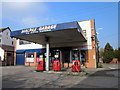
Malpas Garage
by Jeff Buck geograph for square SJ4847 Malpas Garage in Old Hall Street.
Tags:
top:Business, Retail, ServicesX
county:CheshireX
country:EnglandX
GarageX
subject:GarageX
place:Malpas
Petrol PumpsX
top:Village, Rural SettlementX
|
|
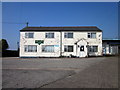
Malpas and District Sports Club
by Jeff Buck geograph for square SJ4847 Malpas and District Sports Club in Church Street needs a lick of paint.
Tags:
Building for SaleX
BuildingsX
top:Business, Retail, ServicesX
county:CheshireX
Derelict BuildingX
country:EnglandX
place:Malpas
top:Village, Rural SettlementX
|
|
Glebe Farmhouse, Church Street, Malpas
by Jeff Buck geograph for square SJ4847 Glebe Farmhouse, a late 17th century cottage, is one of a number of timber... (more)
Tags:
BuildingsX
county:CheshireX
country:EnglandX
top:Housing, DwellingsX
place:Malpas
Timber FramedX
Timber Framed HouseX
top:Village, Rural SettlementX
|
|
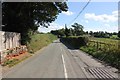
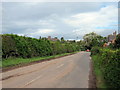
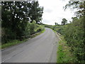
The B5395 (Oldhall Street) near The Hough
by Jeff Buck geograph for square SJ4946 The B5395 heading east away from Malpas near The Hough. The B5395 starts at... (more)
|
|
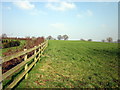
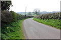
Field and Hedge near Malpas
by Jeff Buck geograph for square SJ4946 The view west from the B5395 near Malpas.
|
|
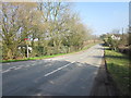
The B5395 approaching Malpas
by Jeff Buck geograph for square SJ4946 The B5395 heading into Malpas. St Oswald's Church, which sits on a hill... (more)
|
|
|
View from Malpas
by Jeff Buck geograph for square SJ4847 The view across the fields towards Wales and the border from Love Lane, Malpas.
|
|
Footpath to Malpas
by Jeff Buck geograph for square SJ4847 This path connects Overton Heath Lane and Church Street in Malpas.
|
|
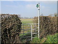
Kissing Gate on Mastiff Lane
by Jeff Buck geograph for square SJ4846 Kissing Gate to a public footpath heading for Malpas.
|
|
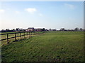
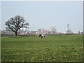
View towards St Oswald's Church
by Jeff Buck geograph for square SJ4846 View across the fields from Mastiff Lane towards St Oswald's Church in Malpas.
|
|
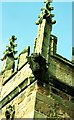
Gargoyle on St Oswald's Church, Malpas
by Jeff Buck for square SJ4847 Gargoyle on the tower of St Oswald's Church.
|
|
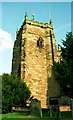
The Tower of St Oswald's Church, Malpas
by Jeff Buck geograph for square SJ4847 St Oswald's Church was built in the second half of the 14th century on the... (more)
|
|
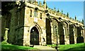
St Oswald's Church, Malpas
by Jeff Buck for square SJ4847 St Oswald's Church was built in the second half of the 14th century on the... (more)
|
|
St Oswald's Church, Malpas
by Jeff Buck geograph for square SJ4847 St Oswald's Church was built in the second half of the 14th century on the... (more)
|
|
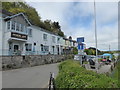
Heron Inn, Malpas
by Chris Allen geograph for square SW8442 A little village near Truro and overlooking the Truro River on its way to Falmouth
Tags:
top:Business, Retail, ServicesX
county:CornwallX
type:GeographX
place:Malpas
subject:Public HouseX
VillageX
top:Village, Rural SettlementX
|
|
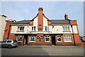
The Red Lion Hotel, Malpas
by Jeff Buck geograph for square SJ4847 The Red Lion Hotel in Old Hall Street was built in 1920.
|
|
The Bishop Bennet Way at Hill Farm
by Jeff Buck geograph for square SJ4844 The Bishop Bennet Way heading north towards Malpas at Hill Farm.
Tags:
Bishop Bennet WayX
long distance path:Bishop Bennet WayX
county:CheshireX
country:EnglandX
LaneX
place:Malpas
top:PathsX
top:Roads, Road TransportX
|
|
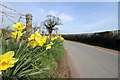
Daffodils beside Mastiff Lane
by Jeff Buck geograph for square SJ4846 Spring has arrived on Mastiff Lane near Malpas.
|
|
B5069 (Wrexham Road) at Cuddington Heath
by Jeff Buck geograph for square SJ4746 The B5069 Wrexham Road as it heads east towards Malpas.
|
|
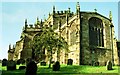
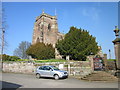
St Oswald's Church, Malpas
by Jeff Buck geograph for square SJ4847 St Oswald's Church as seen from the south west in Church Street.
|
|
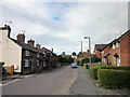
Well Street, Malpas
by Jeff Buck geograph for square SJ4947 Looking west along Well Street towards Old Hall Street. St Oswald's Church... (more)
|
|
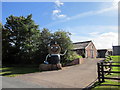
Straw Man at Broselake Farm
by Jeff Buck geograph for square SJ4947 A straw man (possibly related to Bertie Bassett) gives a friendly wave to... (more)
|
|
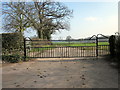
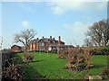
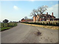
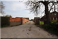
Entrance to Manor Farm, Wychough
by Jeff Buck geograph for square SJ4845 |
|
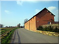
Agden Dairy Farm
by Jeff Buck geograph for square SJ5143 The farm house at Agden Dairy Farm.
Tags:
place:AgdenX
county:CheshireX
Dairy FarmX
country:EnglandX
FarmX
Farm HouseX
top:Farm, Fishery, Market GardeningX
place:Malpas
|
|
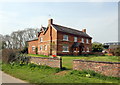
Manor Farm, Wychough
by Jeff Buck geograph for square SJ4845 Manor Farm contains a late Georgian dovecot in the farmyard which is a listed... (more)
Tags:
county:CheshireX
country:EnglandX
FarmX
top:Farm, Fishery, Market GardeningX
top:Housing, DwellingsX
place:Malpas
place:Oldcastle HeathX
|
|
The Bishop Bennet Way at Manor Farm
by Jeff Buck geograph for square SJ4845 The Bishop Bennet Way approaching Manor Farm at Wychough near Oldcastle Heath.
Tags:
long distance path:Bishop Bennet WayX
county:CheshireX
country:EnglandX
LaneX
Long Distance FootpathX
place:Malpas
place:Oldcastle HeathX
top:PathsX
RoadX
top:Roads, Road TransportX
top:Village, Rural SettlementX
|
|
The Bishop Bennet Way at Wychough
by Jeff Buck geograph for square SJ4845 The Bishop Bennet Way passing Manor Farm at Wychough near Oldcastle Heath. The... (more)
Tags:
Barn ConversionX
long distance path:Bishop Bennet WayX
county:CheshireX
country:EnglandX
Long Distance FootpathX
place:Malpas
place:Oldcastle HeathX
top:PathsX
top:Roads, Road TransportX
top:Village, Rural SettlementX
|
|
Mastiff Lane and Bishop Bennet Way
by Jeff Buck geograph for square SJ4846 The Bishop Bennet Way following the route of Mastiff Lane heading west towards... (more)
Tags:
Bishop Bennet WayX
county:CheshireX
country:EnglandX
LaneX
place:Malpas
place:Oldcastle HeathX
RoadX
top:Roads, Road TransportX
|
|
The Bishop Bennet Way
by Jeff Buck geograph for square SJ4844 Tags:
Bishop Bennet WayX
county:CheshireX
country:EnglandX
LaneX
place:Malpas
top:PathsX
top:Roads, Road TransportX
top:Village, Rural SettlementX
|
|
Entrance to Hill Farm
by Jeff Buck geograph for square SJ4844 The entrance to Hill Farm off the Bishop Bennet Way.
Tags:
Barn ConversionsX
county:CheshireX
country:EnglandX
Farm EntranceX
top:Farm, Fishery, Market GardeningX
top:Housing, DwellingsX
place:Malpas
|
|
Bradley Bridge at Bradley Brook
by Jeff Buck geograph for square SJ4946 The B5395 (Oldhall Street) as it passes over Bradley Bridge.
|