Public Tags
Other tags: near:Sandbach
Showing latest 50 of 56 images tagged with place:Sandbach tag.
|
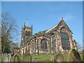
East end of St Mary's parish church, Sandbach
by Stephen Craven geograph for square SJ7560 Category: Church The parish church of St Mary is built on a low hill overlooking the Dingle... (more)
|
|
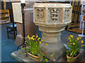
Font of St Mary's Sandbach
by Stephen Craven for square SJ7560 Category: Font The font stands at the rear of the nave, the traditional position to remind... (more)
|
|
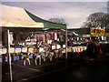
Sandbach market - clothing
by Stephen Craven for square SJ7560 Thursday has long been market day in Sandbach. Clothing stalls are on the... (more)
|
|
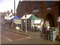
Sandbach market - fruit & veg
by Stephen Craven geograph for square SJ7560 Thursday has long been market day in Sandbach. The greengrocery stalls are... (more)
|
|
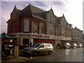
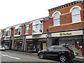
Price City, Sandbach High Street
by Stephen Craven geograph for square SJ7560 This was a Co-Operative department store when I first lived in Sandbach in the... (more)
|
|
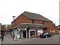
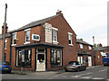
McColls, Sandbach
by Stephen Craven geograph for square SJ7560 A newsagents shop on Penda Way.
Tags:
top:Business, Retail, ServicesX
top:City, Town CentreX
McColls ShopX
NewsagentX
place:Sandbach
|
|
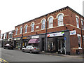
Bold Street: former Co-operative building
by Stephen Craven geograph for square SJ7560 This building was the Sandbach Industrial Co-operative Society Limited,... (more)
Tags:
date:1877X
top:Business, Retail, ServicesX
Charity ShopX
top:City, Town CentreX
Former Co-Operative StoreX
place:Sandbach
|
|
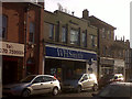
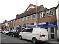
WH Smith, Sandbach High Street
by Stephen Craven geograph for square SJ7560 The shop was a Woolworths store until that chain collapsed at the end of 2008.
Tags:
top:Business, Retail, ServicesX
top:City, Town CentreX
High Street ShopsX
place:Sandbach
WH SmithX
former:WoolworthsX
|
|
The Military Arms
by Stephen Craven geograph for square SJ7560 Category: Public house A Greenall's pub on the edge of Scotch Common in the centre of Sandbach.
|
|
The Lower Chequer, Sandbach
by Stephen Craven geograph for square SJ7560 Category: Public house The pub gets its name by contrast with the Swan and Chequer, higher up the hill... (more)
|
|
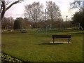
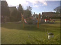
Sandbach park - new play area
by Stephen Craven geograph for square SJ7661 Some of the play equipment installed in 2011 to replace a previous facility SJ7661 : Play area in Sandbach Park.
|
|
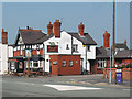
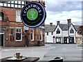
View outside Chatwins
by Jonathan Hutchins geograph for square SJ7560 Tags:
top:Business, Retail, ServicesX
top:City, Town CentreX
type:GeographX
PubX
subject:Public HouseX
RoundaboutX
place:Sandbach
Town CentreX
Town Centre Road JunctionX
View From CafeX
|
|
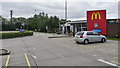
Sandbach Motorway Services
by Rossographer geograph for square SJ7760 Motorway services off the southbound M6 at Sandbach.
Uninspiring.
Tags:
top:Business, Retail, ServicesX
type:GeographX
Motorway ServicesX
subject:Motorway ServicesX
Motorway Services Car ParkX
top:Roads, Road TransportX
place:Sandbach
|
|
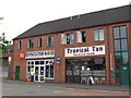
The Commons: fish bar and tanning studio
by Stephen Craven geograph for square SJ7560 Two businesses on the south side of the Commons (or Scotch Common)
Tags:
top:Business, Retail, ServicesX
top:City, Town CentreX
Fish and Chip ShopX
place:Sandbach
Tanning StudioX
|
|
Green Street: oriental resaturant
by Stephen Craven geograph for square SJ7560 A chinese restaurant on the east side of the street.
|
|
Green Street: takeaway and cafe
by Stephen Craven geograph for square SJ7560 An Indian takeaway and a cafe on the west side of the street.
|
|
Bold Street: Oxfam shop
by Stephen Craven geograph for square SJ7560 The charity shop occupies the western end of the former Co-operative building... (more)
|
|
Cross Street: the Stove Centre
by Stephen Craven geograph for square SJ7560 To give it its full name, Cheshire Stoves and Cookers.
|
|
Welles Street: the Ring o' Bells
by Stephen Craven geograph for square SJ7560 A pub on the corner of Welles Street and Cross Street.
|
|
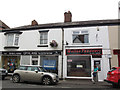
Welles Street: barber and beer
by Stephen Craven geograph for square SJ7560 A man's paradise: shops on the west side of Welles Street, including a... (more)
|
|
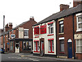
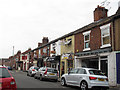
Welles Street: fish shop etc
by Stephen Craven geograph for square SJ7560 Shops on the east side of Welles Street, opposite the end of Bold Street,... (more)
|
|
Welles Street: optician and takeaway
by Stephen Craven geograph for square SJ7560 An opticians and an Indian takeaway.
Tags:
top:Business, Retail, ServicesX
top:City, Town CentreX
Indian TakeawayX
OpticianX
place:Sandbach
|
|
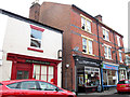
Welles Street: DEBRA shop and former methodist chapel
by Stephen Craven geograph for square SJ7560 A charity shop. Behind the facade can be seen the former Primitive Methodist... (more)
Tags:
Charity ShopX
top:City, Town CentreX
top:Housing, DwellingsX
Methodist Chapel (Former)X
place:Sandbach
|
|
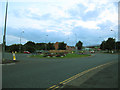
Roundabout on Sandbach Bypass
by Stephen Craven geograph for square SJ7560 This is where the Sandbach bypass (foreground) meets the inner relief road... (more)
|
|
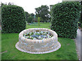
Jubilee flowerbed
by Stephen Craven geograph for square SJ7561 A stone raised flowerbed in Sandbach Park to celebrate the Queen's Diamond Jubilee.
|
|
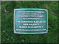
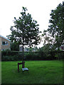
Queen Elizabeth's tree - plaque
by Stephen Craven for square SJ7661 The plaque beneath a tree in Sandbach Park SJ7661 : Queen Elizabeth's tree. Compare SJ7661 : King George's tree - plaque.
|
|
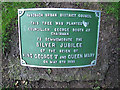
King George's tree - plaque
by Stephen Craven for square SJ7661 A plaque beneath a tree in Sandbach Park SJ7661 : King George's tree.
|
|
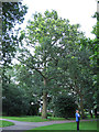
King George's tree
by Stephen Craven geograph for square SJ7661 The plaque beneath this tree in Sandbach Park records that it was planted in... (more)
|
|
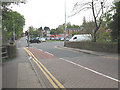
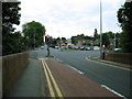
Sandbach Bridge and The Hill
by Stephen Craven geograph for square SJ7660 Category: Road junction For a history and side view of the bridge in the foreground, see SJ7660 : Sandbach Bridge.... (more)
|
|
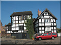
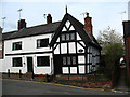
No 10, Well Bank, Sandbach
by Stephen Craven geograph for square SJ7560 Category: Half-timbered cottage This timbered cottage is one of the oldest surviving houses in Sandbach. It has... (more)
Tags:
date:1570X
top:City, Town CentreX
Grade II ListedX
Half TimberedX
Historic BuildingX
place:Sandbach
|
|
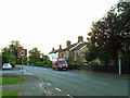
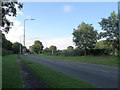
Speed limit approaching Sandbach
by Stephen Craven geograph for square SJ7661 The 30mph limit has started at this point on Congleton Road as long as I can... (more)
|
|
The Railway Children
by Stephen Craven geograph for square SJ7560 The offices of a charity that helps homeless children across the world. This... (more)
Tags:
top:Business, Retail, ServicesX
Charity OfficesX
top:City, Town CentreX
place:Sandbach
Surgery (Former)X
|
|
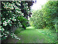
Stile by the Sandbach Bypass
by Stephen Craven geograph for square SJ7661 The stile is where a pre-existing right of way is cut off by the bypass.
|
|
Old Mill Road
by Stephen Craven geograph for square SJ7661 Otherwise known as the A534 Sandbach Bypass. Built in the 1980s.
|
|
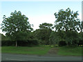
Open space behind the Parkhouse estate
by Stephen Craven geograph for square SJ7661 A strip of green space was left between the housing and the A534 Sandbach Bypass... (more)
|
|
Open space behind the Parkhouse estate
by Stephen Craven geograph for square SJ7661 A strip of green space was left between the housing and the A534 Sandbach Bypass... (more)
|
|
Cycle lane, Sandbach Bridge
by Stephen Craven geograph for square SJ7660 The road across the bridge is now one-way (northbound i.e. towards the town... (more)
|
|
Queen Elizabeth's tree
by Stephen Craven geograph for square SJ7661 The plaque beneath this tree in Sandbach Park records that it was planted in... (more)
|
|
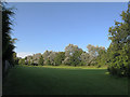
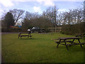
Sandbach park - picnic area
by Stephen Craven geograph for square SJ7661 The picnic area was opened in 2011 on the site of a former playground... (more)
|
|
Sandbach park - new play area
by Stephen Craven geograph for square SJ7661 Some of the play equipment installed in 2011 to replace a previous facility SJ7661 : Play area in Sandbach Park.
|
|
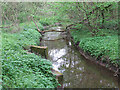
Front Street sewage overflow
by Stephen Craven geograph for square SJ7660 Category: Sewage outfall At the bottom of Sandbach town centre, a water company plaque identifies this as... (more)
|
|
St Mary's church hall, Sandbach
by Stephen Craven geograph for square SJ7560 Category: Church hall The hall is immediately to the west of the parish church SJ7560 : East end of St Mary's parish church, Sandbach.
|
|
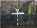
Old style roadsign on former A534
by Stephen Craven geograph for square SJ7561 Category: Road signs Congleton Road used to be the main road into Sandbach from the east, the A534.... (more)
|
|
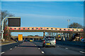
A covered footbridge at M6 Sandbach Services
by Oliver Mills geograph for square SJ7760 Connecting the Northbound and Southbound service sites, this structure appears... (more)
Tags:
subject:BridgeX
top:Business, Retail, ServicesX
Covered BridgeX
bridge:FootbridgeX
type:GeographX
motorway:M6X
top:Public Buildings and SpacesX
RoadchefX
top:Roads, Road TransportX
place:Sandbach
subject:Services (Road)X
|
|
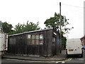
Green Street: old garage
by Stephen Craven geograph for square SJ7560 This wooden shed housing a vehicle repair workshop looks to be a survivor from... (more)
Tags:
top:Business, Retail, ServicesX
top:City, Town CentreX
place:Sandbach
Vehicle Repair CentreX
Wooden BuildingX
|
|
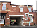
Welles Street: entrance to Embury Court
by Stephen Craven geograph for square SJ7560 Access to this development is through a flat-ceilinged underpass.
|
|
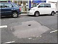
Welles Street: hole in the road
by Stephen Craven for square SJ7560 A nasty looking pothole.
|
|
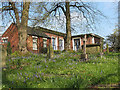
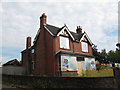
Derelict house on Congleton Road
by Stephen Craven geograph for square SJ7561 I don't think this house had been lived in for some time, but now is boarded up.
Tags:
top:City, Town CentreX
top:Derelict, DisusedX
House (Derelict)X
top:Housing, DwellingsX
place:Sandbach
|
|
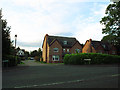
Emerald Drive
by Stephen Craven geograph for square SJ7661 A small housing development off Congleton Road, built (if I recall correctly) in... (more)
|
|
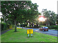
Community Speed Check Area
by Stephen Craven geograph for square SJ7661 It is not clear what this sign means. Do vigilantes patrol the area with speed... (more)
|