|
Meeting point
by M J Richardson
geograph for square NM7435
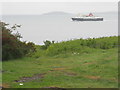
CalMac's 'Isle of Mull', en route from Oban to Mull, passes... (more)
|
|
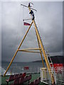
Coastal Argyll : Headless Man In The Sound Of Mull
by Richard West
for square NM5650
I suppose that he must have a head for heights, but where is it?
Maybe his... (more)
|
|
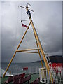
Coastal Argyll : Lord Of The Isles In The Sound Of Mull
by Richard West
for square NM5650
Up the tripod mast on the CalMac ferry MV Lord Of The Isles, passing through the... (more)
|
|
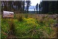
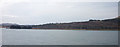
The Sound of Mull appears through a break in the trees on the Fiunary Forest track
by Pat Macleod
geograph for square NM6747
|
|
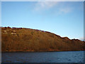
Forestry on Mull
by M J Richardson
for square NM6039
On the eastern side of the valley of the River Forsa, which drains north into... (more)
|
|
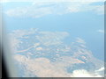
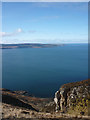
Tobermory and the Sound of Mull
by M J Richardson
for square NM5055
Viewed from the south over Mull, with Ardnamurchan at the top of the picture.
|
|
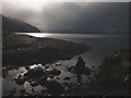
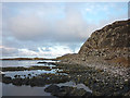
Tidal rocks, Port na Luinge, Kilchoan
by Karl and Ali
geograph for square NM4862
Looking down the Sound of Mull to the distant mountains of Dun da Ghaoithe and... (more)
|
|
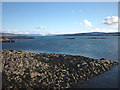
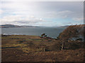
Loch Sunart and the Sound of Mull
by Karl and Ali
for square NM5458
Auliston Point is the tip of land that divides the two bodies of water, seen... (more)
|
|
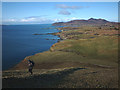
High on the south west ridge of Ben Hiant
by Karl and Ali
geograph for square NM5362
There were many deer in the corrie below - a string can just be seen exiting on... (more)
|
|
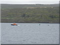
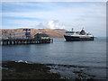
The Tobermory lifeboat with a boat in tow
by M J Richardson
geograph for square NM5552
A Severn-class RNLI boat based at Tobermory, 17-39 'Elizabeth Fairlie... (more)
|
|
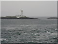
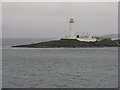
Sgeir nan Gael and the Lismore Lighthouse
by M J Richardson
for square NM7734
Entering the Sound of Mull from the Firth of Lorn.
|
|
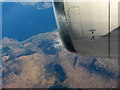
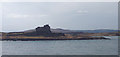
Duart Point and Duart Castle
by M J Richardson
for square NM7435
Looking through the rain from the Oban-Mull ferry
|
|
Rubha an Ridire, Kingairloch
by M J Richardson
for square NM7341
The southern tip of Kingairloch, at the junction of the Sound of Mull and Loch... (more)
|

|
Beached and rotting fishing boats, Salen
by Karl and Ali
geograph for square NM5643
Three old boats slowly but surely weathering away into the Sound of Mull.
|
|
Ardnamurchan coast east of Mingary Castle
by Karl and Ali
geograph for square NM5163
Climbing the slopes of Ben Hiant high above the Sound of Mull, the castle is... (more)
|
|
Larch trees above Pennygown
by Karl and Ali
geograph for square NM6042
Looking down on the cemetery beside the Sound of Mull.
|
|
Crossing the Allt Choire Mhuillin
by Karl and Ali
geograph for square NM5163
At the point where the stream debouches into the Sound of Mull.
|
|
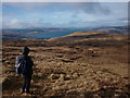
Moorland on Beinn Chreagach Bheag
by Karl and Ali
geograph for square NM6239
Peaty moorland with a few outcrops and rounded tops. Not too exciting after the... (more)
|
|
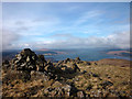
The summit of Beinn Chreagach Mhor (579m)
by Karl and Ali
geograph for square NM6339
A small cairn sits on top with another one slightly lower down. There is a good... (more)
|
|
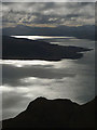
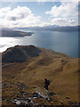
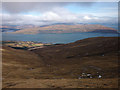
Coire Clachach
by Karl and Ali
geograph for square NM6637
A wide corrie on the north flank of Beinn Thunacaraidh. Below is the Sound of... (more)
|
|
Lady's Rock
by M J Richardson
geograph for square NM7734
At the narrows between the Sound of Mull and the Firth of Lorn.
|
|
Valley above Camas nan Clacha' Mora
by Karl and Ali
geograph for square NM5262
Looking across the sound to northern Mull.
|
|
The Mull coast between Craignure and Torosay Castle
by Karl and Ali
geograph for square NM7336
Seen from the MV 'Isle of Mull' ferry to Oban.
|
|
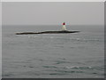
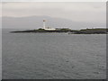
The Lismore Lighthouse
by M J Richardson
for square NM7735
On Eilean Musdile, at the southern end of Lismore. Seen on a wet passage to Mull... (more)
|
|
Duart Point and Castle
by Karl and Ali
geograph for square NM7535
Seen from the MV 'Isle of Mull' car ferry sailing to Oban.
|
|
Rubha na Sròine, Craignure
by Karl and Ali
geograph for square NM7237
The southern limit of Craignure Bay as seen from the MV 'Isle of Mull'... (more)
|
|
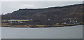
Ferry terminal, Craignure Pier
by Karl and Ali
geograph for square NM7137
The Calmac ferry MV 'Isle of Mull' approaching from Oban. The hills of... (more)
|
|
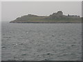
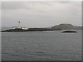
Eilean Musdile
by M J Richardson
for square NM7835
Off the southern tip of Lismore, with the Lismore Lighthouse, the small rocky... (more)
|
|
Sgeir nan Gael and The Lismore Light
by M J Richardson
geograph for square NM7734
Islands at the southern tip of Lismore, with Kingairloch through the rain beyond.
|
|
Wooded shore north of Tobermory
by Karl and Ali
geograph for square NM5156
Catching the first light of dawn as we sail to Ardnamurchan on the Kilchoan ferry.
|
|
Shoreline near Kilchoan
by Karl and Ali
geograph for square NM4963
It is possible to traverse the shore from the pier direct to Mingary Castle at low tide.
|
|
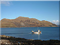
Fishing boat leaving Mingary Pier
by Karl and Ali
geograph for square NM4962
While we waited for the Tobermory ferry this boat arrived, off-loaded fish to a... (more)
|
|
Arrival at Mingary Pier, Ardnamurchan
by Karl and Ali
geograph for square NM4962
The 'Raasay' at the slipway shortly after depositing us in... (more)
|
|
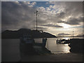
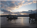
The 'Raasay' gets ready for Kilchoan
by Karl and Ali
geograph for square NM5055
It is hard to get up before dawn to catch a ferry but the trip over to... (more)
|