Public Tags
Showing images tagged with place:St Davids tag.
|
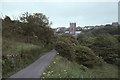
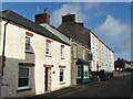
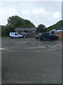
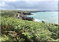
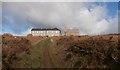
Approaching St David's from the west
by Christopher Hilton geograph for square SM7425 Tags:
Cathedral (Church in Wales)X
LaneX
PembrokeshireX
national park:Pembrokeshire CoastX
place:Pembrokeshire/Sir BenfroX
Pembrokeshire/Sir BenfroX
top:Religious SitesX
top:Roads, Road TransportX
place:St Davids
cathedral:St Davids
place:St Davids CathedralX
|
|
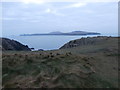
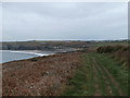
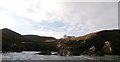
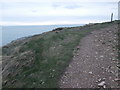
Point St John and Penrhyn Dalar
by HelenK geograph for square SM7125 The section of the Pembrokeshire Coast Path which goes round the headland beyond... (more)
|
|
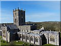
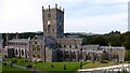
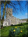
St Davids Cathedral
by Robin Drayton geograph for square SM7525 Viewed from beneath the Bell Tower.
The building of the cathedral began in 1181... (more)
|
|
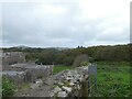
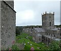
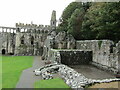
St David's Cathedral Close Walls
by Gerald England geograph for square SM7525
To the left is the cathedral. On the right is the site of St Mary's Well.... (more)
Tags:
13th CenturyX
14th CenturyX
type:GeographX
top:Historic Sites and ArtefactsX
Holy Well (Site Of)X
top:Religious SitesX
place:St Davids
cathedral:St Davids
WallX
|
|
St David's - Nun Street / Heol Non
by Colin Smith geograph for square SM7525 City centre street named after St Non, mother of the Welsh patron saint, St... (more)
|
|
Looking down towards St David's Cathedral
by Gerald England geograph for square SM7525 The Cathedral as it stands today was begun by Norman Bishop Peter de Leia in... (more)
|
|
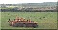
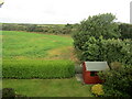
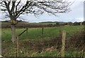
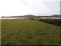
St David's - Farming Landscape
by Colin Smith geograph for square SM7625 Grassy fields lined with hedgerows east of St David's.
Link
|
|
St David's - Window on Wales
by Colin Smith geograph for square SM7525 Brightly painted tourist shop in central St David's.
Link
Tags:
top:Business, Retail, ServicesX
top:City, Town CentreX
type:GeographX
subject:ShopX
place:St Davids
Tourist ShopX
|
|
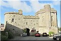
St David's Cathedral - Tower Gate
by Colin Smith geograph for square SM7525 The gatehouse with bell tower, known as Porth y Twr (Tower Gate) is the only... (more)
Tags:
Bell TowerX
subject:GatehouseX
type:GeographX
top:Historic Sites and ArtefactsX
place:St Davids
|
|
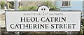
St David's City - Catherine Street
by Colin Smith for square SM7525 Dinas Tyddewi - Heol Catrin.
Bilingual street signs are common in St... (more)
Tags:
BilingualX
type:Close LookX
top:Roads, Road TransportX
subject:SignX
place:St Davids
Street SignX
|
|
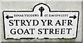
St David's City - Goat Street
by Colin Smith for square SM7525 Dinas Tyddewi - Stryd Yr Afr.
Bilingual street signs are common in St... (more)
Tags:
BilingualX
type:Close LookX
top:Roads, Road TransportX
subject:SignX
place:St Davids
Street SignX
|
|
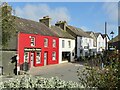
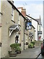
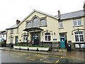
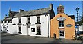
St David's - The Farmers Arms
by Colin Smith geograph for square SM7525 Popular pub on Goat Street in St David's, UK's smallest city.
Tags:
top:Business, Retail, ServicesX
Farmers Arms Public HouseX
type:GeographX
subject:Public HouseX
place:St Davids
|
|
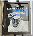
St David's - The Farmers Arms
by Colin Smith for square SM7525 Sign with a common pub name in rural Pembrokeshire - on Goat Street, St David's.
Tags:
top:Business, Retail, ServicesX
type:Close LookX
Farmers Arms Public HouseX
Pub SignsX
subject:SignX
place:St Davids
|
|
St David's Cathedral - Tower Gate
by Colin Smith geograph for square SM7525 The gatehouse with bell tower, known as Porth y Twr (Tower Gate) is the only... (more)
Tags:
Bell TowerX
subject:GatehouseX
type:GeographX
top:Historic Sites and ArtefactsX
place:St Davids
|
|
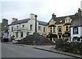
St David's - City Hall
by Colin Smith geograph for square SM7525 "The City Hall is centrally located in the High Street and offers... (more)
|
|
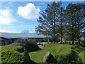
St David's - Visitor Centre
by Colin Smith geograph for square SM7525 "Oriel y Parc Gallery and Visitor Centre in St Davids is owned and managed... (more)
|
|
National Trust car park, Porthclais
by HelenK geograph for square SM7324 A car park run by the National Trust, which supplies information on the area and... (more)
Tags:
Car ParkX
top:CoastalX
former:Gas WorksX
type:GeographX
National TrustX
place:PorthclaisX
top:Roads, Road TransportX
top:Sport, LeisureX
place:St Davids
top:Village, Rural SettlementX
|
|
St David's Cathedral
by Rude Health geograph for square SM7525 Tags:
subject:CathedralX
top:City, Town CentreX
top:LowlandsX
top:Religious SitesX
place:St Davids
St Davids CathedralX
|
|
Oriel y Parc Gallery and Visitor Centre, St Davids
by Robin Drayton geograph for square SM7525 Owned and managed by the Pembrokeshire Coast National Park Authority.
This is a... (more)
Tags:
GalleryX
place:PembrokeshireX
place:St Davids
top:Suburb, Urban FringeX
subject:TourismX
Tourist Information CentreX
Visitor CentreX
|
|
Tourist Information Centre, St Davids
by Robin Drayton geograph for square SM7525 Owned and managed by the Pembrokeshire Coast National Park Authority.
The upper... (more)
Tags:
GalleryX
place:PembrokeshireX
place:St Davids
top:Suburb, Urban FringeX
Tourist Information CentreX
|
|
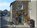
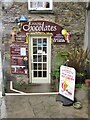
Chapel Chocolates, St Davids
by Robin Drayton geograph for square SM7525 Sells handmade and handcrafted Welsh Chocolates and other confectionery.
Tags:
top:Business, Retail, ServicesX
ChocolatiersX
top:City, Town CentreX
ConfectionersX
place:PembrokeshireX
subject:ShopX
place:St Davids
|
|
Pebbles Yard Gallery, St Davids
by Robin Drayton geograph for square SM7525 An espresso bar and gallery showing photography, jewellery and ceramics.
Tags:
top:Business, Retail, ServicesX
top:City, Town CentreX
Coffee ShopX
subject:GalleryX
place:PembrokeshireX
place:St Davids
|
|
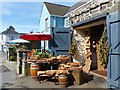
Tinkers Kitchen, St Davids
by Robin Drayton geograph for square SM7525 Handcrafted chopping boards produced and for sale here.
Tags:
top:Business, Retail, ServicesX
top:City, Town CentreX
Craft ShopX
place:PembrokeshireX
place:St Davids
|
|
St Davids Cathedral
by Robin Drayton geograph for square SM7525 Viewed from the south-west.
The building of the cathedral began in 1181 on the... (more)
|
|
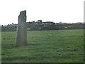
St David's - Standing Stone
by Colin Smith geograph for square SM7625 Prehistoric standing stone NW of Trecenny Farm.
|
|
St David's
by Colin Smith geograph for square SM7425 Grassy fields lined by hedgerows on the edge of UK's smallest city.... (more)
|
|
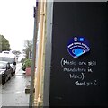
Shop small safely
by Gerald England geograph for square SM7525
At the entrance to a shop on St David's High Street a sign reads:
SHOP... (more)
Tags:
top:Business, Retail, ServicesX
top:City, Town CentreX
Coronavirus PandemicX
Face MaskX
type:GeographX
place:St Davids
|
|
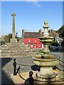
St David's - Cross Square
by Colin Smith geograph for square SM7525 The Old Celtic Cross and a fountain are prominent features in the city centre.... (more)
Tags:
Celtic CrossX
top:City, Town CentreX
FountainX
type:GeographX
top:Historic Sites and ArtefactsX
subject:SquareX
place:St Davids
|
|
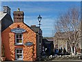
St David's - The Bishops
by Colin Smith geograph for square SM7525 Historic and popular city centre pub named after the local Bishop Rocks.... (more)
Tags:
top:Business, Retail, ServicesX
top:City, Town CentreX
type:GeographX
subject:Public HouseX
place:St Davids
|
|
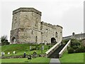
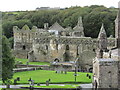
St David's - Bishops Palace
by Colin Smith geograph for square SM7525 Henry de Gower, between 1328 and 1347, developed a building only fit for... (more)
Tags:
type:GeographX
top:Historic Sites and ArtefactsX
subject:PalaceX
top:Religious SitesX
Ruined Bishops PalaceX
place:St Davids
|
|
St David's - Bishops Palace
by Colin Smith geograph for square SM7525 Henry de Gower, between 1328 and 1347, developed a building only fit for... (more)
Tags:
type:GeographX
top:Historic Sites and ArtefactsX
subject:PalaceX
top:Religious SitesX
Ruined Bishops PalaceX
place:St Davids
|
|
St David's - Chapel Chocolates
by Colin Smith for square SM7525 Chapel Chocolates is a popular shop in the city centre. It is a family business... (more)
Tags:
top:Business, Retail, ServicesX
Chocolate ShopX
type:Close LookX
subject:ShopX
place:St Davids
|
|
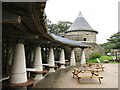
St David's - Sculpture
by Colin Smith geograph for square SM7525 Stone circle sculpture surrounding a clump of trees beside the visitor centre.... (more)
|
|
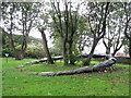
Multiple nest boxes
by HelenK geograph for square SM7526 This tree sports several nest boxes, awaiting habitation by birds that like... (more)
Tags:
top:Farm, Fishery, Market GardeningX
type:GeographX
top:LowlandsX
Nest BoxX
top:PathsX
Public FootpathX
place:St Davids
top:Village, Rural SettlementX
|
|
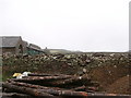
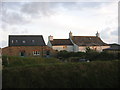
Penlan Farmhouse and Cottage
by HelenK geograph for square SM7425 These are now rented as holiday lets through Coastal Cottages of Pembrokeshire,... (more)
Tags:
CottageX
top:Farm, Fishery, Market GardeningX
former:FarmhouseX
type:GeographX
Holiday LetX
top:Housing, DwellingsX
place:St Davids
top:Village, Rural SettlementX
|
|
Porthselau and the southern end of Whitesands Bay/Traeth Mawr
by HelenK geograph for square SM7226 At Porthselau the Pembroskeshire Coast path dips down giving access to the... (more)
Tags:
BeachX
CamouflageX
Caravan ParkX
top:CoastalX
type:GeographX
top:Housing, DwellingsX
top:PathsX
long distance path:Pembrokeshire Coast PathX
place:PencarnanX
place:PorthselauX
place:St Davids
|
|
The farmhouse, Ramsey Island
by HelenK geograph for square SM7023 There is some farmland on Ramsey Island, although the occupants of the farmhouse... (more)
Tags:
Cadw-Registered BuildingX
top:Docks, HarboursX
top:Farm, Fishery, Market GardeningX
FarmhouseX
type:GeographX
top:Housing, DwellingsX
top:IslandsX
place:Ramsey IslandX
top:Rocks, Scree, CliffsX
RSPBX
place:St Davids
|
|
Treginnis Isaf
by HelenK geograph for square SM7223 The farm at Treginnis Isaf (Lower Treginnis) is owned by the National Trust and... (more)
|
|
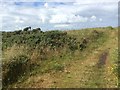
Looking towards the westernmost point
by HelenK geograph for square SM7123 This path connects with the Pembrokeshire Coast Path near Pen Dal-aderyn, the... (more)
Tags:
top:CoastalX
top:Farm, Fishery, Market GardeningX
type:GeographX
top:PathsX
long distance path:Pembrokeshire Coast PathX
island:Ramsey IslandX
place:St Davids
place:TreginnisX
|
|
Path parallel to coastal path
by HelenK geograph for square SM7323 This path diverges from the Pembrokeshire Coastal Path and runs parallel to it... (more)
|
|
Looking across Porthclais
by HelenK geograph for square SM7423 Taken from the National Trust coastal path. The cliff face opposite was being... (more)
Tags:
Cliff FaceX
top:CoastalX
top:Estuary, MarineX
type:GeographX
HeadlandX
path:Pembrokeshire Coast PathX
place:PorthclaisX
place:St Davids
top:Village, Rural SettlementX
|
|
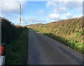
The road to Whitesands
by HelenK geograph for square SM7426 A narrow lane with passing places. The last of a cautionary line of bollards... (more)
Tags:
BollardX
top:CoastalX
top:Farm, Fishery, Market GardeningX
type:GeographX
top:Roads, Road TransportX
place:St Davids
top:Village, Rural SettlementX
|
|
Lower Treleddyn Farm
by HelenK geograph for square SM7325 The farmhouse can be rented for holidays.
Tags:
Converted FarmhouseX
top:Farm, Fishery, Market GardeningX
top:Housing, DwellingsX
top:LowlandsX
place:RhossonX
top:Sport, LeisureX
place:St Davids
|
|
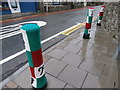
Musical yarnbombing
by HelenK for square SM7525 These bollard covers appeared over Christmas where Nun St meets Cross Square.... (more)
Tags:
BollardsX
top:Business, Retail, ServicesX
top:City, Town CentreX
type:Close LookX
KnittingX
MusicX
top:Roads, Road TransportX
place:St Davids
Yarn BombingX
YarnbombingX
|
|
Chapel of Our Lady and St Non, and retreat house
by HelenK geograph for square SM7524 The chapel was constructed by Cecil Morgan-Griffiths for his wife in the... (more)
|
|
Pembrokeshire Coastal Path at Pen y Cyfrwy
by HelenK geograph for square SM7523 The path bends round this little headland. A marker post has been set up to... (more)
Tags:
top:CoastalX
type:GeographX
top:PathsX
long distance path:Pembrokeshire Coast PathX
place:St Davids
top:Village, Rural SettlementX
Waymark PoleX
|
|
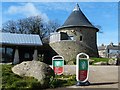
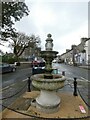
Roach drinking fountain
by Gerald England geograph for square SM7525
The ornamental drinking fountain in Cross Square was given by Captain Roach... (more)
Tags:
date:1912X
date:1974X
top:City, Town CentreX
Drinking FountainX
FountainX
type:GeographX
Grade II ListedX
material:GraniteX
top:Historic Sites and ArtefactsX
place:St Davids
|
|
City Cross
by Gerald England geograph for square SM7525
The medieval City Cross dates from the 14th century. Its octagonal shaft and... (more)
Tags:
14th CenturyX
date:1873X
Celtic CrossX
top:City, Town CentreX
CrossX
type:GeographX
Grade II(star) Listed StructureX
top:Historic Sites and ArtefactsX
Lloyds PharmacyX
Medieval CrossX
milestoneid:PEM STDX
PharmacyX
Scheduled Ancient MonumentX
place:St Davids
Wayside CrossX
|
|
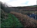
The Bishop's water-wheel
by HelenK geograph for square SM7424 The mechanism of the water-wheel is embedded in the house on the right.
Tags:
top:Farm, Fishery, Market GardeningX
type:GeographX
top:Housing, DwellingsX
top:PathsX
top:Rivers, Streams, DrainageX
place:St Davids
top:Village, Rural SettlementX
Water WheelX
|