Public Tags
Other tags: near:St Mary Cray
Showing latest 50 of 75 images tagged with place:St Mary Cray tag.
|
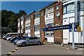
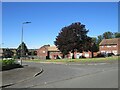
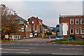
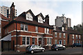
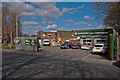
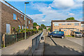
St Mary Cray Station car park
by Ian Capper geograph for square TQ4668 St Mary Cray Station car park with the rear of shops in Sayes Court Road on the right.
Tags:
top:Business, Retail, ServicesX
Car ParkX
type:GeographX
place:OrpingtonX
top:RailwaysX
place:St Mary Cray
St Mary Cray StationX
place:St Pauls CrayX
Station ApproachX
top:Suburb, Urban FringeX
|
|
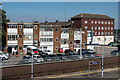
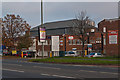
St Mary Cray Station
by Ian Capper geograph for square TQ4668 Looking across the platforms of St Mary Cray Station with the station car park... (more)
Tags:
top:Business, Retail, ServicesX
Car ParkX
type:GeographX
Maryon CourtX
place:OrpingtonX
top:RailwaysX
Sayes Court RoadX
place:St Mary Cray
St Mary Cray StationX
place:St Pauls CrayX
Station ApproachX
top:Suburb, Urban FringeX
|
|
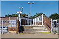
St Mary Cray Station
by Ian Capper geograph for square TQ4668 The southern access to St Mary Cray Station off Furzehill Square.
Tags:
Furzehill SquareX
type:GeographX
place:OrpingtonX
place:PoverestX
top:RailwaysX
place:St Mary Cray
St Mary Cray StationX
top:Suburb, Urban FringeX
|
|
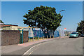
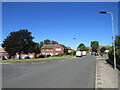
Furzehill Square
by Ian Capper geograph for square TQ4668 Alongside the southern access to St Mary Cray Station off Furzehill Square.
Tags:
Furzehill SquareX
type:GeographX
place:OrpingtonX
place:PoverestX
top:RailwaysX
place:St Mary Cray
St Mary Cray StationX
top:Suburb, Urban FringeX
|
|
Berens Road, St Mary Cray
by Malc McDonald geograph for square TQ4767 Berens Road is a residential road in St Mary Cray, in the outer suburbs of south... (more)
Tags:
near:BromleyX
type:GeographX
Housing EstateX
subject:Housing EstateX
building type:Housing EstateX
top:Housing, DwellingsX
near:OrpingtonX
ResidentialX
Residential AreaX
Residential RoadX
place:South East LondonX
place:St Mary Cray
top:Suburb, Urban FringeX
near:SwanleyX
|
|
Burrfield Drive, St Mary Cray
by Malc McDonald geograph for square TQ4767 Burrfield Drive is a residential road in St Mary Cray, in the outer suburbs of... (more)
Tags:
near:BromleyX
type:GeographX
building type:Housing EstateX
Housing EstateX
subject:Housing EstateX
top:Housing, DwellingsX
near:OrpingtonX
ResidentialX
Residential AreaX
Residential RoadX
place:South East LondonX
place:St Mary Cray
top:Suburb, Urban FringeX
near:SwanleyX
|
|
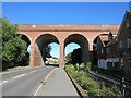
Railway viaduct, St Mary Cray
by Malc McDonald geograph for square TQ4768 A railway viaduct in St Mary Cray, in the outer suburbs of south east London.... (more)
|
|
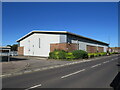
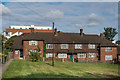
Warehouse in St Mary Cray
by Malc McDonald geograph for square TQ4768 A warehouse in St Mary Cray, in the outer suburbs of south east London.
|
|
Murray Road, St Mary Cray
by Malc McDonald geograph for square TQ4668 Murray Road accesses a small industrial estate in St Mary Cray, in the outer... (more)
Tags:
near:BromleyX
type:GeographX
Industrial AreaX
Industrial EstateX
subject:Industrial SiteX
Industrial UnitsX
top:IndustryX
near:OrpingtonX
place:South East LondonX
place:St Mary Cray
near:SwanleyX
|
|
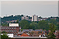
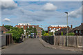
Towards St Mary Cray
by Ian Capper for square TQ4768 A telephoto view towards the two St Mary Cray tower blocks, Alkham Tower (on the... (more)
Tags:
Alkham TowerX
Allied HouseX
top:Business, Retail, ServicesX
Horton TowerX
top:Housing, DwellingsX
place:OrpingtonX
place:St Mary Cray
top:Suburb, Urban FringeX
|

|
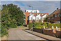
Houses on Leesons Hill, St Mary Cray
by Malc McDonald geograph for square TQ4668 Houses on Leesons Hill, in St Mary Cray in the outer suburbs of south east... (more)
Tags:
near:BromleyX
type:GeographX
HousesX
building type:HousesX
subject:HousesX
Housing EstateX
building type:Housing EstateX
top:Housing, DwellingsX
near:OrpingtonX
ResidentialX
Residential AreaX
Residential RoadX
ShadowsX
place:South East LondonX
place:St Mary Cray
top:Suburb, Urban FringeX
Sunlight and ShadowsX
near:SwanleyX
|
|
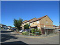
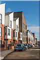
Sayes Court Road, St Mary Cray
by Malc McDonald geograph for square TQ4668 Houses on Sayes Court Road in St Mary Cray, in the outer suburbs of South East London.
Tags:
near:BromleyX
type:GeographX
subject:HousesX
HousesX
building type:HousesX
top:Housing, DwellingsX
Modern HousesX
Modern HousingX
near:OrpingtonX
ResidentialX
Residential AreaX
Residential RoadX
place:South East LondonX
place:St Mary Cray
top:Suburb, Urban FringeX
near:SwanleyX
|
|
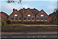
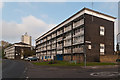
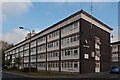
St Mary Cray Primary School
by Ian Capper geograph for square TQ4767 A Community School for children aged 5 - 11 years. A plaque on the right hand... (more)
|
|
Lagoon Road
by Ian Capper geograph for square TQ4667 The A224 Cray Avenue was built in the 1930s as one of the London arterial roads... (more)
|
|
Lagoon Road
by Ian Capper geograph for square TQ4667 The A224 Cray Avenue was built in the 1930s as one of the London arterial roads... (more)
|
|
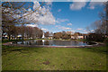
Pond, St Mary Cray
by Ian Capper geograph for square TQ4667 Marked on large scale maps as a model boating pond. In the left background is... (more)
Tags:
Cray AvenueX
Kent RoadX
top:Lakes, Wetland, BogX
Model Boating PondX
top:Sport, LeisureX
place:St Mary Cray
top:Suburb, Urban FringeX
|
|
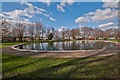
Pond, St Mary Cray
by Ian Capper geograph for square TQ4667 Marked on large scale maps as a model boating pond. In the background is Cray Avenue.
Tags:
Cray AvenueX
top:Lakes, Wetland, BogX
Model Boating PondX
top:Sport, LeisureX
place:St Mary Cray
top:Suburb, Urban FringeX
|
|
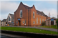
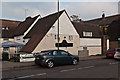
The Temple
by Ian Capper geograph for square TQ4767 The United Reformed Church for St Mary Cray.
The original Temple was built in... (more)
|
|
Denvale Trade Centre
by Ian Capper geograph for square TQ4667 Warehouses on Cray Avenue. The A224 Cray Cray Avenue was built in the 1930s as... (more)
|
|
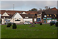
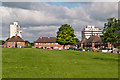
St Mary Cray Green
by Ian Capper geograph for square TQ4768 The Green at the junction of High Street and Sandway Road. In the centre is the... (more)
Tags:
GreenX
top:Park and Public GardensX
place:St Mary Cray
top:Suburb, Urban FringeX
Village SignX
|
|
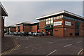
Ravensquay Business Centre
by Ian Capper geograph for square TQ4667 A business park on Cray Avenue. The A224 Cray Avenue was built in the 1930s as... (more)
|

|
Cray Avenue
by Ian Capper geograph for square TQ4667 The A224 Cray Avenue was built in the 1930s as one of the London arterial roads,... (more)
Tags:
top:Business, Retail, ServicesX
Cray AvenueX
top:Roads, Road TransportX
place:St Mary Cray
top:Suburb, Urban FringeX
|
|
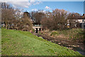
River Cray
by Ian Capper geograph for square TQ4667 The River Cray, less than half a mile form its source in Priory Gardens,... (more)
Tags:
Kent RoadX
River CrayX
top:Rivers, Streams, DrainageX
place:St Mary Cray
top:Suburb, Urban FringeX
|
|
St Mary Cray Village Hall
by Ian Capper geograph for square TQ4767 Village hall on High Street. In 2007 the Village Hall Trust won the Bromley... (more)
Tags:
High StreetX
top:Public Buildings and SpacesX
place:St Mary Cray
top:Suburb, Urban FringeX
Village HallX
|
|
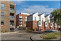
Riverside Court
by Ian Capper geograph for square TQ4767 One of a number of similar housing blocks in St Mary Cray. In the background is... (more)
|
|
Forgefield Court
by Ian Capper geograph for square TQ4767 One of a number of similar housing blocks in St Mary Cray.
Tags:
Forgefield CourtX
High StreetX
top:Housing, DwellingsX
place:St Mary Cray
top:Suburb, Urban FringeX
|
|
The Old Police Station
by Ian Capper geograph for square TQ4768 The Old Police Station on High Street in St Mary Cray, dating from 1896. It... (more)
|
|
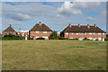
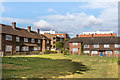
Okemore Gardens
by Ian Capper geograph for square TQ4768 1950s housing around an open green. In the background are the two St Mary Cray... (more)
Tags:
Alkham TowerX
Horton TowerX
top:Housing, DwellingsX
Okemore GardensX
place:St Mary Cray
top:Suburb, Urban FringeX
|
|
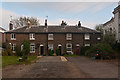
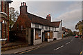
Cray Cottages
by Ian Capper geograph for square TQ4767 Row of cottages at 221-229 High Street dating from 1860. Locally listed.
Tags:
Cray CottagesX
High StreetX
top:Housing, DwellingsX
Locally ListedX
place:St Mary Cray
top:Suburb, Urban FringeX
|
|
Cray Valley Hub
by Ian Capper geograph for square TQ4768 Community youth support centre and young people's flats housed in the... (more)
Tags:
Black BoyX
Cray Valley HubX
top:Health and Social ServicesX
High StreetX
top:Housing, DwellingsX
place:St Mary Cray
top:Suburb, Urban FringeX
|
|
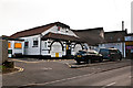
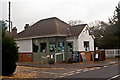
Travis Perkins
by Ian Capper geograph for square TQ4667 Builders' merchants on Kent Road near its junction with Cray Avenue.
|
|
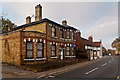
Mary Rose Hotel
by Ian Capper geograph for square TQ4768 Grade II listed inn dating originally from the 17th century - for listing... (more)
Tags:
top:Business, Retail, ServicesX
Grade II ListedX
Mary Rose HotelX
place:St Mary Cray
top:Suburb, Urban FringeX
|
|
The Ridge
by Ian Capper geograph for square TQ4768 A development completed in 2014 on the site of the 1968 Alkham Tower (see... (more)
|
|
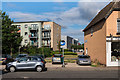
Okemore Gardens
by Ian Capper geograph for square TQ4768 1950s housing around an open green. In the background is part of the 2014 The... (more)
Tags:
type:GeographX
top:Housing, DwellingsX
Okemore GardensX
place:St Mary Cray
top:Suburb, Urban FringeX
|
|
Withen Close
by Ian Capper geograph for square TQ4768 Road off Okemore Gardens. In the background is part of the 2014 The Ridge development.
Tags:
type:GeographX
top:Housing, DwellingsX
place:St Mary Cray
top:Suburb, Urban FringeX
Withen CloseX
|
|
Withen Close
by Ian Capper geograph for square TQ4768 1950s housing off Okemore Gardens. In the background is part of the 2014 The... (more)
Tags:
type:GeographX
top:Housing, DwellingsX
place:St Mary Cray
top:Suburb, Urban FringeX
Withen CloseX
|
|
Withen Close
by Ian Capper geograph for square TQ4768 1950s housing off Okemore Gardens. In the background is part of the 2014 The... (more)
Tags:
type:GeographX
top:Housing, DwellingsX
place:St Mary Cray
top:Suburb, Urban FringeX
Withen CloseX
|
|
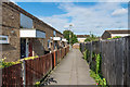
Sandway Path
by Ian Capper geograph for square TQ4768 Housing off Sandway Road.
Tags:
type:GeographX
top:Housing, DwellingsX
Sandway PathX
place:St Mary Cray
top:Suburb, Urban FringeX
|
|
Oldbury Close
by Ian Capper geograph for square TQ4768 Housing off Sandway Road.
Tags:
type:GeographX
top:Housing, DwellingsX
Oldbury CloseX
place:St Mary Cray
top:Suburb, Urban FringeX
|
|
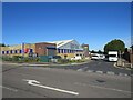
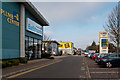
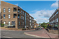
Towards the Nugent Shopping Centre
by Ian Capper geograph for square TQ4768 Looking across High Street and Millbrook Road towards housing and shops in the... (more)
Tags:
top:Business, Retail, ServicesX
type:GeographX
High StreetX
top:Housing, DwellingsX
Millbrook RoadX
Nugent Shopping CentreX
place:St Mary Cray
top:Suburb, Urban FringeX
|
|
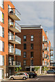
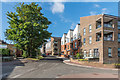
The Ridge
by Ian Capper geograph for square TQ4768 Part of The Ridge, a development completed in 2014 on the site of the 1968... (more)
Tags:
Alkham TowerX
Apex HouseX
type:GeographX
Horton TowerX
top:Housing, DwellingsX
Pinnacle HouseX
place:St Mary Cray
top:Suburb, Urban FringeX
The RidgeX
|
|
Mountfield Way
by Ian Capper geograph for square TQ4768 Looking along Mountfield Way from its junction with Okemore Gardens. The... (more)
|
|
Okemore Gardens
by Ian Capper geograph for square TQ4768 Looking along Okemore Gardens. The buildings are part of The Ridge, a... (more)
|
|
Okemore Gardens
by Ian Capper geograph for square TQ4768 Part of The Ridge, a development completed in 2014 on the site of the 1968... (more)
Tags:
Alkham TowerX
type:GeographX
top:Housing, DwellingsX
Okemore GardensX
place:St Mary Cray
top:Suburb, Urban FringeX
The RidgeX
|
|
Okemore Gardens
by Ian Capper geograph for square TQ4768 The housing on the right was built in the 1950s. By contrast in the background... (more)
Tags:
Alkham TowerX
type:GeographX
top:Housing, DwellingsX
Okemore GardensX
place:St Mary Cray
top:Suburb, Urban FringeX
The ApexX
The RidgeX
|
|
Kent Row
by Ian Capper geograph for square TQ4767 A short terrace of lcoally listed cottages on Kent Road.
Tags:
top:Housing, DwellingsX
Kent RoadX
Kent RowX
Locally ListedX
place:St Mary Cray
top:Suburb, Urban FringeX
|
|
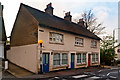
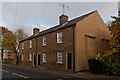
322 High Street
by Ian Capper geograph for square TQ4767 A doctorr's and dentists' surgery at the south end of High Street.
Tags:
top:Health and Social ServicesX
High StreetX
place:St Mary Cray
top:Suburb, Urban FringeX
SurgeryX
|
|
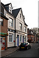
316-318 High Street
by Ian Capper geograph for square TQ4767 18th century grade II listed building - see... (more)
Tags:
top:Business, Retail, ServicesX
Grade II ListedX
High StreetX
place:St Mary Cray
top:Suburb, Urban FringeX
|
|
Croft Tea Room
by Ian Capper geograph for square TQ4767 Tea room opened in 2009 with a community emphasis.
Tags:
top:Business, Retail, ServicesX
Croft Tea RoomX
High StreetX
place:St Mary Cray
top:Suburb, Urban FringeX
Tea RoomX
|
|
247-253 High Street
by Ian Capper geograph for square TQ4767 Mid Victorian terrace of cottages. Locally listed.
Tags:
High StreetX
top:Housing, DwellingsX
Locally ListedX
place:St Mary Cray
top:Suburb, Urban FringeX
|