Geograph - photograph every grid square
About tags on Geograph
Tags
Geographical Context
Subjects
Types
Other Prefixes
Public Tags
Related Tags
|
Coverage Map
Prefix:
place
Tag:
Millers·Dale
Other tags:
Millers Dale
near:
Millers Dale
Showing images tagged with
place:
Millers Dale
tag.
View all tagged images
-
In Browser
Search within these images
:
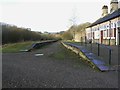
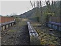
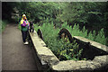
Millers Dale for Tideswell station
by
John Winder
geograph for square
SK1373
The old railway station at Millers Dale (no apostrophe), taken back in 2012. The... (
more
)
Tags:
top:
Derelict, Disused
X
Disused Railway
X
Flanders & Swann
X
type:
Geograph
X
Midland Railway
X
place:
Millers Dale
Monsall Trail
X
Old Railway
X
Old Railway Staton
X
top:
Paths
X
subject:
Railway Station
X
top:
Railways
X
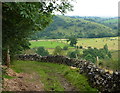
Limestone Way above Miller's Dale
by
Andrew Hill
geograph for square
SK1373
A bend in the track with Monk's Dale directly below and the far side of... (
more
)
Tags:
Limestone Way
X
place:
Millers Dale
top:
Paths
X
Track
X
top:
Uplands
X
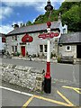
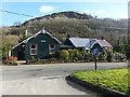
The Anglers Rest
by
Graham Hogg
geograph for square
SK1473
Pub and restaurant in Millers Dale. The lamppost probably came from the nearby... (
more
)
Tags:
top:
Business, Retail, Services
X
type:
Geograph
X
place:
Millers Dale
subject:
Public House
X
Public House & Restaurant
X
top:
Village, Rural Settlement
X
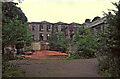
Litton Mill, Miller's Dale
by
Chris Allen
geograph for square
SK1672
A former textile mill that was looking derelict in 1993 and has now been... (
more
)
Tags:
top:
Derelict, Disused
X
type:
Geograph
X
top:
Industry
X
subject:
Mill
X
place:
Millers Dale
former:
Textile Mill
X
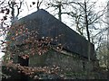
Former railway water tank
by
John Winder
geograph for square
SK1373
A surprising survivor on the old Midland main line at Millers Dale is this water... (
more
)
Tags:
top:
Derelict, Disused
X
Disused Railway
X
type:
Geograph
X
Midland Railway
X
place:
Millers Dale
Old Railway
X
Old Railway Water Tank
X
subject:
Railway Infrastructure
X
top:
Railways
X
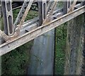
Millers Dale viaduct (disused)
by
John Winder
geograph for square
SK1373
The Midland Railway built two viaducts at Millers Dale on what was their main... (
more
)
Tags:
top:
Derelict, Disused
X
Disused Railway
X
Disused Railway Viaduct
X
type:
Geograph
X
Midland Railway
X
place:
Millers Dale
Old Railway
X
top:
Railways
X
Viaduct
X
subject:
Viaduct
X
The Wriggly Tin
by
Dave Dunford
geograph for square
SK1373
Formerly a café (
SK1373 : Miller's bridge
) but now holiday accommodation, viewed from the... (
more
)
Tags:
subject:
Accommodation
X
building material:
Corrugated Iron
X
type:
Geograph
X
Holiday Cottage
X
place:
Millers Dale
place:
Monsal Trail
X
top:
Sport, Leisure
X
top:
Village, Rural Settlement
X
View down to the road from the southern viaduct
by
Andrew Hill
for square
SK1373
Looking down from the Monsal Trail on the viaduct at Miller's Dale. The... (
more
)
Tags:
road:
B6049
X
place:
Millers Dale
top:
Railways
X
Road
X
Viaduct
X
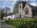
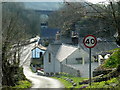
Miller's Dale in the spring
by
Andrew Hill
geograph for square
SK1473
A bank of daffodils by the lane junction with the church and a row of cottages opposite.
Tags:
Church
X
Cottages
X
Daffodils
X
Lane Junction
X
place:
Millers Dale
Village
X
top:
Village, Rural Settlement
X
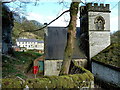
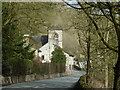
St Anne's Church, Miller's Dale
by
Andrew Hill
geograph for square
SK1473
The little church is squeezed between the road and a low line of crags. A path... (
more
)
Tags:
Church
X
Crag
X
Houses
X
place:
Millers Dale
top:
Religious Sites
X
Valley
X
top:
Village, Rural Settlement
X
Lane into Miller's Dale village from Litton Mill
by
Andrew Hill
geograph for square
SK1473
The lane keeps close to the river along the valley floor.
Tags:
Houses
X
Lane
X
place:
Millers Dale
top:
Roads, Road Transport
X
Village
X
top:
Village, Rural Settlement
X
Litton Mill, Miller's Dale
by
Chris Allen
geograph for square
SK1672
This building with a chimney is now identified as the 'gas house' and... (
more
)
Tags:
Chimney
X
top:
Derelict, Disused
X
type:
Geograph
X
top:
Historic Sites and Artefacts
X
top:
Industry
X
subject:
Mill
X
place:
Millers Dale
former:
Textile Mill
X
Litton Mill, Miller's Dale
by
Chris Allen
geograph for square
SK1672
A former textile mill that already looks derelict in this view from 1993. It has... (
more
)
Tags:
top:
Derelict, Disused
X
type:
Geograph
X
top:
Historic Sites and Artefacts
X
top:
Industry
X
subject:
Mill
X
place:
Millers Dale
former:
Textile Mill
X
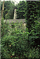
Abandoned waterwheel, Miller's Dale
by
Chris Allen
geograph for square
SK1672
Between Litton Mill and Cressbrook Mill. It was a bit damp.
Tags:
top:
Derelict, Disused
X
type:
Geograph
X
place:
Millers Dale
top:
Rivers, Streams, Drainage
X
top:
Water Resources
X
subject:
Waterwheel
X
river:
Wye (Derbyshire)
X
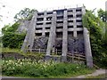
Lime kiln near Miller's Dale station
by
Graham Hogg
geograph for square
SK1373
A commercial kiln dating from the early 20th century processed limestone from... (
more
)
Tags:
top:
Derelict, Disused
X
Lime Kiln
X
place:
Millers Dale
Monsal Trail
X
top:
Paths
X
top:
Quarrying, Mining
X
top:
Railways
X
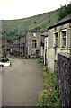
Meadow Lane descending into Miller's Dale village
by
Andrew Hill
geograph for square
SK1473
The lane drops through steep woodland to the little village, here seen in... (
more
)
Tags:
Church
X
Crag
X
Houses
X
Lane
X
place:
Millers Dale
Trees
X
Valley
X
Viaduct
X
Village
X
top:
Village, Rural Settlement
X
Road through Miller's Dale
by
Andrew Hill
geograph for square
SK1473
The road (B6049) is in a well wooded valley, with houses and the church catching... (
more
)
Tags:
Church
X
Houses
X
place:
Millers Dale
Road
X
top:
Roads, Road Transport
X
Trees
X
Village
X
top:
Village, Rural Settlement
X
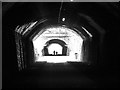
Chee Tor No. 2 tunnel from inside No. 1
by
John Winder
for square
SK1273
A tricky one to photograph because of the different light levels. Still a little... (
more
)
Tags:
Chee Tor
X
Chee Tor No. 1
X
Chee Tor No.2
X
top:
Derelict, Disused
X
type:
Inside
X
Midland Railway
X
place:
Millers Dale
Monsall Trail
X
Old Railway
X
Old Railway Tunnel
X
top:
Paths
X
subject:
Railway Infrastructure
X
top:
Railways
X
Bridge over the River Wye
by
Graham Hogg
geograph for square
SK1573
A footbridge leading to a steep ascent to the Monsal Trail.
Tags:
subject:
Bridge
X
Footbridge
X
type:
Geograph
X
place:
Millers Dale
top:
Paths
X
River Wye
X
top:
Rivers, Streams, Drainage
X
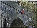
Abseiling from the viaduct
by
John Winder
for square
SK1373
I mentioned in the caption to
SK1373 : Viaduct in Millers Dale
that it was used as an abseiling... (
more
)
Tags:
Abseilling
X
type:
Close Look
X
Disused Railway Viaduct
X
place:
Millers Dale
Monsall Trail
X
Old Railway
X
top:
People, Events
X
top:
Railways
X
top:
Sport, Leisure
X
subject:
Viaduct
X
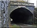
Chee Tor No. 2 tunnel
by
John Winder
geograph for square
SK1273
The west portal of Chee Tor No. 2 tunnel; the longer No. 1 tunnel is visible in... (
more
)
Tags:
Chee Tor
X
Chee Tor No.2
X
top:
Derelict, Disused
X
type:
Geograph
X
Midland Railway
X
place:
Millers Dale
Monsall Trail
X
Old Railway
X
Old Railway Tunnel
X
top:
Paths
X
subject:
Railway Infrastructure
X
top:
Railways
X
Footbridge across the River Wye near Litton Mill
by
Andrew Hill
geograph for square
SK1573
The bridge crosses the wide river to the houses of the small village west of the mill.
Tags:
Footbridge
X
near:
Litton Mill
X
place:
Millers Dale
top:
Paths
X
River
X
top:
Village, Rural Settlement
X
river:
Wye (Derbyshire)
X
View more in the Image Search
or
in Browser
View images matching 'Millers Dale' anywhere
in
the tags
Don't click these:
PotMel 1
PotMel 2
☰
Home
View
Search
Marked Images
Maps
Browser
Explore
Showcase
New Images
Collections
Interact
Games
Discussions
Blog
Contributors
Submit
Statistics
Leaderboards
General
FAQ
Help Pages
Sitemap
Contact Us
Support Us
sponsored by
🔍
What to search:
Photos
Enter keywords or a location/postcode to search nearby images
Enter a Grid Reference
Placenames
Collections
Website Pages
Everything
Others:
Advanced Search
|
Image Browser
Or:
Coverage Map
|
Searchable Map
You are not logged in
login
|
register