Geograph - photograph every grid square
About tags on Geograph
Tags
Geographical Context
Subjects
Types
Other Prefixes
Public Tags
Related Tags
|
Coverage Map
Prefix:
place
Tag:
Westbury·Park
Other tags:
near:
Westbury Park
Showing images tagged with
place:
Westbury Park
tag.
View all tagged images
-
In Browser
Search within these images
:
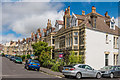
Harcourt Road
by
Ian Capper
geograph for square
ST5775
Early 20th Century villas in Westbury Park, with this area being called New... (
more
)
Tags:
place:
Bristol
X
type:
Geograph
X
Harcourt Road
X
top:
Housing, Dwellings
X
place:
New Clifton
X
top:
Suburb, Urban Fringe
X
place:
Westbury Park
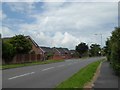
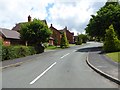
Westbury Park: Westbury Road
by
Jonathan Hutchins
geograph for square
SJ8442
Tags:
type:
Geograph
X
top:
Housing, Dwellings
X
Road
X
top:
Roads, Road Transport
X
Suburb
X
subject:
Suburb
X
top:
Suburb, Urban Fringe
X
place:
Westbury Park
Westbury Park: path off Westbury Road
by
Jonathan Hutchins
geograph for square
SJ8442
Tags:
Dog Waste Bin
X
Footpath
X
type:
Geograph
X
top:
Housing, Dwellings
X
Litter Bin
X
subject:
Path Junction
X
top:
Paths
X
Pavement
X
Suburb
X
top:
Suburb, Urban Fringe
X
place:
Westbury Park
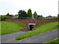
Westbury Park: underpass on Westbury Road
by
Jonathan Hutchins
geograph for square
SJ8442
Tags:
Footpath
X
Footpath Junction
X
type:
Geograph
X
Graffiti
X
top:
Paths
X
Pedestrian Underpass
X
Suburb
X
top:
Suburb, Urban Fringe
X
Underpass
X
subject:
Underpass
X
place:
Westbury Park
Westbury Park: The Brambles
by
Jonathan Hutchins
geograph for square
SJ8542
Tags:
type:
Geograph
X
top:
Housing, Dwellings
X
place:
Newcastle-Under-Lyme
X
top:
Roads, Road Transport
X
subject:
Suburb
X
top:
Suburb, Urban Fringe
X
place:
Westbury Park
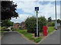
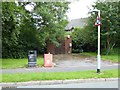
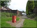
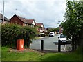
Westbury Park: National Grid installation
by
Jonathan Hutchins
geograph for square
SJ8543
Tags:
Dog Waste Bin
X
top:
Energy Infrastructure
X
type:
Geograph
X
Litter Bin
X
National Grid
X
Road
X
top:
Roads, Road Transport
X
subject:
Roadside
X
Roundabout Sign
X
Suburb
X
top:
Suburb, Urban Fringe
X
Warning Sign Roundabout
X
place:
Westbury Park
Westbury Park: path to underpass
by
Jonathan Hutchins
geograph for square
SJ8442
Tags:
Footpath
X
type:
Geograph
X
Graffiti
X
top:
Housing, Dwellings
X
subject:
Path
X
top:
Paths
X
Pedestrian Underpass
X
Suburb
X
top:
Suburb, Urban Fringe
X
place:
Westbury Park
Westbury Park: Woodbridge Road
by
Jonathan Hutchins
geograph for square
SJ8442
Tags:
type:
Geograph
X
top:
Housing, Dwellings
X
Road Junction
X
top:
Roads, Road Transport
X
Suburb
X
subject:
Suburb
X
top:
Suburb, Urban Fringe
X
place:
Westbury Park
Westbury Park: graffiti in underpass
by
Jonathan Hutchins
for square
SJ8442
Tags:
subject:
Graffiti
X
Graffiti
X
type:
Inside
X
top:
Paths
X
Pedestrian Underpass
X
top:
People, Events
X
Suburb
X
top:
Suburb, Urban Fringe
X
Underpass
X
place:
Westbury Park
Westbury Park: graffiti in underpass
by
Jonathan Hutchins
for square
SJ8442
Tags:
type:
Close Look
X
top:
Geological Interest
X
Graffiti
X
subject:
Graffiti
X
type:
Inside
X
top:
Paths
X
Pedestrian Underpass
X
top:
People, Events
X
Suburb
X
top:
Suburb, Urban Fringe
X
Underpass
X
place:
Westbury Park
Westbury Park: graffiti in underpass
by
Jonathan Hutchins
for square
SJ8442
Tags:
type:
Close Look
X
Graffiti
X
subject:
Graffiti
X
top:
Paths
X
Pedestrian Underpass
X
top:
People, Events
X
top:
Suburb, Urban Fringe
X
Underpass
X
place:
Westbury Park
Westbury Park: path to Prestbury Avenue
by
Jonathan Hutchins
geograph for square
SJ8442
Tags:
Dog Waste Bin
X
Footpath
X
type:
Geograph
X
top:
Housing, Dwellings
X
subject:
Path
X
top:
Paths
X
Suburb
X
top:
Suburb, Urban Fringe
X
top:
Waste, Waste Management
X
place:
Westbury Park
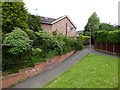
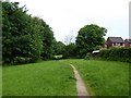
Westbury Park: path behind houses
by
Jonathan Hutchins
geograph for square
SJ8442
Tags:
Footpath
X
type:
Geograph
X
Grassland
X
top:
Grassland
X
top:
Housing, Dwellings
X
subject:
Path
X
top:
Paths
X
Suburb
X
top:
Suburb, Urban Fringe
X
place:
Westbury Park
top:
Woodland, Forest
X
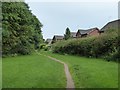
Westbury Park: path behind houses
by
Jonathan Hutchins
geograph for square
SJ8442
Tags:
Footpath
X
type:
Geograph
X
top:
Grassland
X
Grassland
X
top:
Housing, Dwellings
X
subject:
Path
X
top:
Paths
X
Suburb
X
top:
Suburb, Urban Fringe
X
place:
Westbury Park
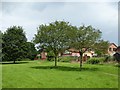
Westbury Park: path behind houses
by
Jonathan Hutchins
geograph for square
SJ8442
Tags:
Footpath
X
type:
Geograph
X
top:
Grassland
X
Grassland
X
top:
Housing, Dwellings
X
subject:
Path
X
top:
Paths
X
top:
Suburb, Urban Fringe
X
place:
Westbury Park
Westbury Park: Bircham Walk
by
Jonathan Hutchins
geograph for square
SJ8442
Tags:
Cul-De-Sac
X
Dog Waste Bin
X
type:
Geograph
X
top:
Housing, Dwellings
X
top:
Roads, Road Transport
X
Roadside Bollards
X
subject:
Suburb
X
top:
Suburb, Urban Fringe
X
top:
Waste, Waste Management
X
place:
Westbury Park
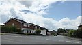
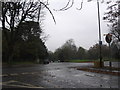
Parrys Lane meets Savile Road
by
HelenK
geograph for square
ST5775
Taken from the edge of Durdham Down... (
more
)
Tags:
place:
Bristol
X
top:
Lowlands
X
top:
Park and Public Gardens
X
Road Junction
X
top:
Roads, Road Transport
X
top:
Suburb, Urban Fringe
X
place:
Westbury Park
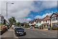
Upper Cranbrook Road
by
Ian Capper
for square
ST5775
Upper Cranbrook Road is shown undeveloped on the 1903 6 inch map, but building... (
more
)
Tags:
place:
Bristol
X
type:
Cross Grid
X
top:
Housing, Dwellings
X
top:
Suburb, Urban Fringe
X
Upper Cranbrook Road
X
place:
Westbury Park
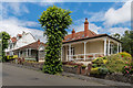
2 and 4 Linden Road
by
Ian Capper
geograph for square
ST5875
Pair of distinctive bungalows with verandahs, situated at the fork of Linden... (
more
)
Tags:
place:
Bristol
X
Bungalow
X
type:
Geograph
X
top:
Housing, Dwellings
X
Linden Road
X
top:
Suburb, Urban Fringe
X
Verandah
X
place:
Westbury Park
View more in the Image Search
or
in Browser
View images matching 'Westbury Park' anywhere
in
the tags
Don't click these:
PotMel 1
PotMel 2
☰
Home
View
Search
Marked Images
Maps
Browser
Explore
Showcase
New Images
Collections
Interact
Games
Discussions
Blog
Contributors
Submit
Statistics
Leaderboards
General
FAQ
Help Pages
Sitemap
Contact Us
Support Us
sponsored by
🔍
What to search:
Photos
Enter keywords or a location/postcode to search nearby images
Enter a Grid Reference
Placenames
Collections
Website Pages
Everything
Others:
Advanced Search
|
Image Browser
Or:
Coverage Map
|
Searchable Map
You are not logged in
login
|
register