Public Tags
Other tags: without the windscreen:A1068
Showing images tagged with road:A1068 tag.
|
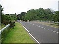
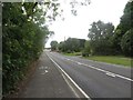
The A1068 crossing the A1
by Graham Robson geograph for square NU2012 This bridge carries the A1068 across the A1. The A1068 road connects Alnmouth... (more)
|
|
Road junction north west of Hagg House
by Graham Robson geograph for square NZ2693 A junction on the A1068 road north west of Hagg House farm. The minor road... (more)
|
|
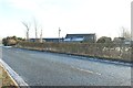
The A1068 at Hagg House
by Graham Robson geograph for square NZ2692 Looking across the A1068 road as it passes the farm at Hagg House. Some of the... (more)
|
|
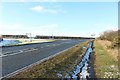
The A1068 or Beal Bank, near Amble
by Graham Robson geograph for square NU2504 Looking along the footpath which is adjacent to the A1068 road between Warkworth... (more)
|
|
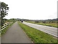
Footpath alongside the A1068
by Graham Robson geograph for square NU2505 Looking along the shared cycle path and footpath alongside the A1068 between... (more)
|
|
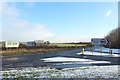
Road junction east of Widdrington Station
by Graham Robson geograph for square NZ2693 A road junction between the minor road which heads in a south easterly direction... (more)
|
|
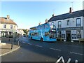
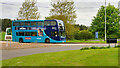
X18 at Warkworth
by Gerald England geograph for square NU2406
The Arriva X18 service just passing the Hermitage Inn has come from Alnwick.... (more)
|
|
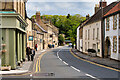
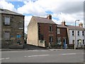
Bridge Street Warkworth
by Adrian Taylor geograph for square NU2406 The north end of Bridge Street. In the foreground is the A1068 road beyond... (more)
Tags:
road:A1068
Defensive GateX
Defensive TowerX
Fortified BridgeX
type:GeographX
top:Historic Sites and ArtefactsX
subject:RoadX
top:Roads, Road TransportX
top:Village, Rural SettlementX
WarkworthX
place:WarkworthX
Warkworth BridgeX
|
|
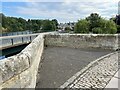
Warkworth Old Bridge
by Adrian Taylor geograph for square NU2406 The east cutwater of Warkworth Old Bridge provided a passing place for traffic... (more)
Tags:
road:A1068
subject:BridgeX
Cut Bench MarkX
Cut BenchmarkX
CutwaterX
type:GeographX
top:Historic Sites and ArtefactsX
NorthumberlandX
Ordnance Survey Bench MarkX
Ordnance Survey BenchmarkX
River CoquetX
Stone Bridge ParapetX
Stone ParapetX
top:Village, Rural SettlementX
WarkworthX
Warkworth BridgeX
|
|
Warkworth, Bridge Street
by David Dixon geograph for square NU2406 The A1068 through the village of Warkworth.
|
|
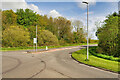
Roundabout west of Ellington
by Graham Robson geograph for square NZ2792 A roundabout where Front Street, Ellington, meets the A1068 on the western edge... (more)
|
|
Hawkhill Bridge
by Barbara Carr geograph for square NU2112 Crossing the River Aln on the A1068.
|
|
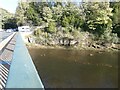
River Coquet
by Gerald England geograph for square NU2406
Flowing under the 1965 bridge that carries the A1068 through Warkworth.
|
|
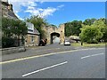
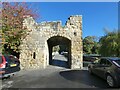
Warkworth Old Bridge
by Gerald England geograph for square NU2406
Warkworth Bridge and its defensive gateway is a Scheduled Monument... (more)
Tags:
14th CenturyX
date:1965X
road:A1068
river:CoquetX
Defensive TowerX
Fortified BridgeX
Fourteenth CenturyX
type:GeographX
Grade II ListedX
Medieval BridgeX
top:PathsX
top:Rivers, Streams, DrainageX
top:Roads, Road TransportX
Scheduled Ancient MonumentX
top:Village, Rural SettlementX
place:WarkworthX
Warkworth BridgeX
|
|
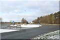
A106 near to Widdrington
by David Dixon geograph for square NZ2595 Traffic island at the junction of the A1068 and B1337 just south of Widdrington.
Tags:
road:A1068
type:GeographX
camera:Panasonic DMC-G7X
top:Roads, Road TransportX
RoundaboutX
Traffic IslandX
|
|
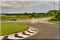
A1068/A189 Junction
by David Dixon geograph for square NZ2790 Tags:
road:A1068
type:GeographX
JunctionX
camera:Panasonic DMC-G7X
top:Roads, Road TransportX
RoundaboutX
Traffic IslandX
|
|
Warkworth House Hotel
by Gerald England geograph for square NU2406 The Grade II* listed... (more)
Tags:
date:1822X
road:A1068
top:Business, Retail, ServicesX
type:GeographX
Grade II(star) ListedX
HotelX
person:John ForsterX
top:Village, Rural SettlementX
place:WarkworthX
|
|
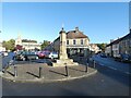
Warkworth Market Cross
by Gerald England geograph for square NU2406
The Grade II listed... (more)
Tags:
date:1706X
date:1830X
road:A1068
former:Cooperative StoreX
person:Duke of NorthumberlandX
Former Co-Operative StoreX
type:GeographX
Grade I ListedX
Grade II ListedX
Market CrossX
Parish ChurchX
ShopX
top:Village, Rural SettlementX
place:WarkworthX
|
|
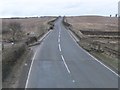
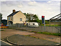
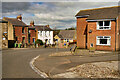
White House on the A1068 at Radcliffe
by David Dixon geograph for square NU2602 |
|
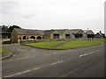
Farm steading at Alndyke
by Graham Robson geograph for square NU2012 The farm buildings forming the roadside farm steading at Alndyke beside the A1068.
|
|
Arriva Bus at Widdrington
by David Dixon geograph for square NZ2596 Arriva North East 7512 (NK57 GXE), a Dennis Trident Enviro400 double decker... (more)
|
|
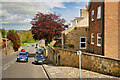
The top of The Wynd
by Adrian Taylor geograph for square NU2604 The small street between the houses is Gloster Terrace and leads to the Masonic... (more)
Tags:
road:A1068
AmbleX
type:GeographX
subject:HousesX
top:Housing, DwellingsX
Masonic HallX
Red Brick HousesX
top:Roads, Road TransportX
StreetX
Terrace HousingX
WyndX
|
|
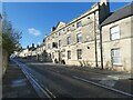
The Wynd, Gloster Hill, Amble
by David Dixon geograph for square NU2604 Amble is a town at the mouth of the River Coquet, on the North Sea coast of... (more)
Tags:
road:A1068
type:GeographX
HousesX
top:Housing, DwellingsX
camera:Panasonic DMC-G7X
top:Suburb, Urban FringeX
|
|
Amble, The Wynd
by David Dixon geograph for square NU2604 Amble is a town at the mouth of the River Coquet, on the North Sea coast of... (more)
Tags:
road:A1068
top:City, Town CentreX
type:GeographX
HousesX
top:Housing, DwellingsX
camera:Panasonic DMC-G7X
|
|
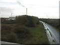
Power station at Cramlington
by M J Richardson for square NZ2478 A biomass CHP power plant. It supplies electricity and heat to Aesica... (more)
Tags:
road:A1068
BiomassX
CHPX
place:CramlingtonX
type:Cross GridX
top:Energy InfrastructureX
Industrial EstateX
top:IndustryX
top:LowlandsX
place:NorthumberlandX
subject:Power StationX
|