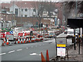
|
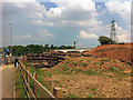
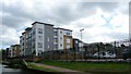
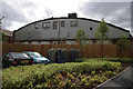
Selly Oak New Road Phase 2 construction site
by Phil Champion
geograph for square SP0483
A new relief road was under construction, designed to take pressure off Bristol... (more)
|
|
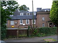
Telephone Exchange, Selly Oak
by David Hillas
geograph for square SP0583
Category: Telephone Exchange
Situated in Oakfield Road at the junction with Serpentine Road, this TE, which... (more)
|
|
New Fosse Way (Selly Oak New Road, Phase 1)
by Phil Champion
geograph for square SP0483
Phase one of the Selly Oak New Road scheme involved the construction of a link... (more)
|
|
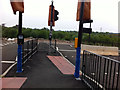
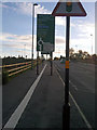
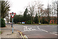
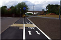
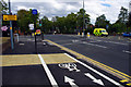
Pedestrian crossings and a road to nowhere
by Phil Champion
geograph for square SP0482
On a roundabout where the Selly Oak New Road (Aston Webb Boulevard) joins... (more)
|
|
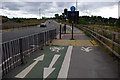
Shared use path alongside Aston Webb Boulevard (Selly Oak New Road, Phase 1)
by Phil Champion
geograph for square SP0483
Approaching the Harborne Lane roundabout. Apparently its ok to obstruct the... (more)
|
|
Shared use path at the Queen Elizabeth Island Roundabout, Selly Oak New Road
by Phil Champion
geograph for square SP0483
Shared use path at the Queen Elizabeth Island Roundabout, Selly Oak New Road
|
|
Shared use path at Queen Elizabeth Island roundabout, Selly Oak New Road
by Phil Champion
geograph for square SP0483
The roads leading to this roundabout, part of the Selly Oak New Road scheme have... (more)
|
|
The 'piazza' between Grange Road and Selly Oak New Road
by Phil Champion
geograph for square SP0483
This area of paving was installed as part of a new relief road.
From the... (more)
|
|
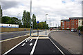
Pedestrian crossing and cycle path - Selly Oak New Road Phase 2 (Aston Webb Boulevard)
by Phil Champion
geograph for square SP0483
The section of road seen here had only opened that morning. This is part of the... (more)
|
|
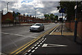
Junction of Bristol Road and Aston Webb Boulevard, Bournbrook
by Phil Champion
geograph for square SP0483
The road swinging to the right is a new relief road (Selly oak New Road Phase... (more)
|
|
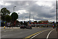
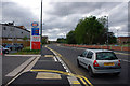
Bristol Road, Bournbrook, near the Gun Barrels and Bournbrook Fire Station
by Phil Champion
geograph for square SP0583
This section of the A38 had recently been widened as part of the Selly Oak New... (more)
|

|
Bristol Road, Bournbrook, near Birmingham University's South Gate
by Phil Champion
geograph for square SP0583
This section of the A38 had recently been widened as part of the Selly Oak New... (more)
|
|
Route of Dudley No. 2 (Lapal) Canal
by Chris Allen
geograph for square SP0382
Planning is well advanced to reinstate the 5.5 mile length of canal from... (more)
|
|
Junction of Willow Road with Raddlebarn Road, Bournville
by Phil Champion
geograph for square SP0481
Across the road is Selly Oak Hospital.
|
|
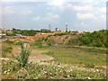
Waste land next to Aston Webb Boulevard (Selly Oak New Road, Phase 1)
by Phil Champion
geograph for square SP0482
In the distance can be seen the construction site for phase 2, involving a new... (more)
|
|
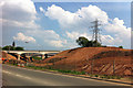
Selly Oak New Road
by Phil Champion
geograph for square SP0483
The new railway and canal bridges were constructed in December 2010. New link... (more)
|
|
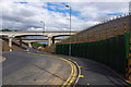
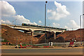
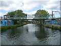
Railway bridge over Selly Oak New Road Phase 2
by Phil Champion
geograph for square SP0483
The railway bridge for the Cross City Line and the parallel canal bridge were... (more)
|
|
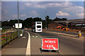
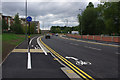
Roadworks on Bristol Road, Bournbrook
by Phil Champion
geograph for square SP0583
Widening works near the Bourn Brook and Arley Road to accommodate a junction... (more)
|
|
Shared use cycle path alongside Aston Webb Boulevard (Selly Oak New Road, Phase 1)
by Phil Champion
geograph for square SP0483
Things start to get interesting for cyclists at a pedestrian crossing, where the... (more)
|
|
Compound near the Queen Elizabeth Roundabout, Selly Oak New Road scheme
by Phil Champion
geograph for square SP0483
Phase 2 of the new relief road scheme had opened that morning. This compound... (more)
|
|
Culvert under the railway embankment near Queen Elizabeth Island roundabout
by Phil Champion
geograph for square SP0483
As part of the works to construct Selly Oak New Road, a new culvert has been... (more)
|
|
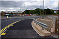
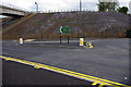
Start / end of Selly Oak New Road Phase 2, at Queen Elizabeth Island roundabout
by Phil Champion
geograph for square SP0483
A new relief road to take pressure off Bristol Road at Bournbrook. The new... (more)
|
|
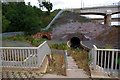
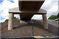
Underneath the railway bridge - Selly Oak New Road, Phase 2
by Phil Champion
geograph for square SP0483
The new relief road passes beneath the Worcester and Birmingham Canal and the... (more)
|
|
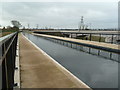
Ariel Aqueduct - Aston Webb Boulevard (Selly Oak New Road, Phase 2)
by Phil Champion
geograph for square SP0483
This new relief road had only opened a few hours earlier. I don't expect... (more)
|
|
Segregated shared use path alongside Aston Webb Boulevard (Selly Oak New Road, Phase 2)
by Phil Champion
geograph for square SP0483
Looking towards the new canal and railway bridges.
|
|
Cycle path alongside Dale Road and Aston Web Boulevard (Selly Oak New Road, Phase 2)
by Phil Champion
geograph for square SP0483
The new relief road had opened that morning.
|
|
Shared use path alongside Aston Webb Boulevard and Dale Road
by Phil Champion
geograph for square SP0483
Approaching the 'piazza' at the end of Grange Road and the gates into... (more)
|
|
Shared use path alongside Aston Webb Boulevard (Selly Oak New Road- Phase 2)
by Phil Champion
geograph for square SP0483
The new relief road had only opened that morning.
|
|
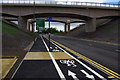
Aston Webb Boulevard, Bournbrook
by Phil Champion
geograph for square SP0483
Phase 2 of the Selly Oak New Road scheme, this section of relief road had only... (more)
|
|
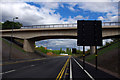
Junction of Selly Oak New Road Phase 2 (Aston Webb Boulevard) and Bristol Road, Bournbrook
by Phil Champion
geograph for square SP0483
The new section of road to the left of the photographers position had opened that morning.
|
|
Shared use path on Bristol Road, Bournbrook
by Phil Champion
geograph for square SP0583
Marked out as an afterthought for cyclists as part of the Selly Oak New Road... (more)
|
|
Ariel Aqueduct
by Chris Allen
for square SP0483
Note spelling. New aqueduct over the Selly Oak bypass.
|
|
Sainsbury's Selly Oak and the Dudley No. 2 (Lapal) Canal
by Chris Allen
geograph for square SP0482
This shows the course that will be taken by the restored Dudley No. 2 (Lapal)... (more)
|
|
Selly Oak Court student accommodation
by Christine Johnstone
geograph for square SP0482
Off Elliott Road, on the west bank of the Worcester & Birmingham Canal.
|
|
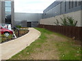
Contractor's footbridge, Worcester & Birmingham Canal
by Christine Johnstone
geograph for square SP0482
A former industrial area known as the Battery site is being redeveloped as Selly... (more)
|
|
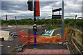
Ariel Aqueduct, Selly Oak
by Chris Allen
geograph for square SP0483
Carrying the Worcester & Birmingham canal over the new bypass road. This is... (more)
|
|
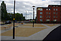
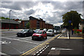
Sports pitches at Birmingham University
by Phil Champion
geograph for square SP0483
Sports pitches at Birmingham University.
|
|
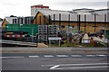
Rear of Rich Bitch Studios, Bournbrook
by Phil Champion
geograph for square SP0483
Many of the older buildings in this area of Bournbrook have been demolished to... (more)
|
|
An unused shared use path - Harborne Lane roundabout
by Phil Champion
geograph for square SP0482
Put in as part of phase 1 of the Selly Oak New Road scheme, this spur of road... (more)
|
|
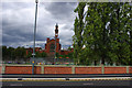
Welcome to Edgbaston - sign on Bristol Road, Bournbrook
by Phil Champion
geograph for square SP0483
But not if you're a cyclist, as the poles supporting the sign obstruct the... (more)
|
|
Segregated shared use path near Birmingham University's South Gate, Bournbrook
by Phil Champion
geograph for square SP0483
Approaching the junction the white line delineating the segregated part of the... (more)
|
|
Segregated shared use path and advanced stop line reservoir near Birmingham University's South Gate, Bournbrook
by Phil Champion
geograph for square SP0483
Approaching the junction the white line delineating the segregated part of the... (more)
|
|
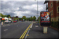
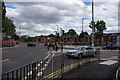
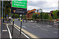
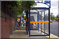
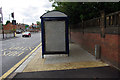
Bus shelter on Bristol Road, Bournbrook
by Phil Champion
for square SP0583
Near Birmingham University's South Gate. Believe it or not this is a shared... (more)
|
|
Bus shelter on Bristol Road, Bournbrook
by Phil Champion
geograph for square SP0583
Believe it or not this is a shared use path. The sections north and south have a... (more)
|
|
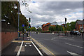
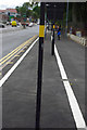
An obstructed cycle path, Bournbrook
by Phil Champion
geograph for square SP0583
The cycle part of this two-way segregated shared use path along Bristol Road is... (more)
|
|
Segregated shared use path and advanced stop line near the Gun Barrels pub, Bournbrook
by Phil Champion
geograph for square SP0583
The wide footway on this section of Bristol Road had recently been converted to... (more)
|
|
Segregated shared use path and advanced stop line near the Gun Barrels pub, Bournbrook
by Phil Champion
geograph for square SP0583
The wide footway on this section of Bristol Road had recently been converted to... (more)
|
|
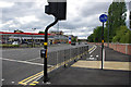
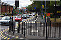
Pedestrian railings at the junction of Bristol Road and Edgbaston Park Road, Bournbrook
by Phil Champion
geograph for square SP0583
Near the Gun Barrels public house.
Note the freshly painted two way... (more)
|
|
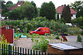
Allotments near Aston Webb Boulevard
by Phil Champion
geograph for square SP0382
A fine crop of sundflowers.
|
|
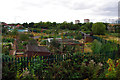
Allotments near Aston Webb Boulevard
by Phil Champion
geograph for square SP0483
|