Public Tags
Tag: Standpipe
Showing images tagged with Standpipe tag.
|
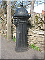
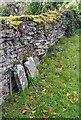
Standpipe in Turvey
by Stephen Craven for square SP9452 Category: Fire hydrant I originally described this as a fire hydrant, but another contributor has... (more)
|
|
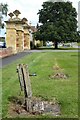
Standpipe in Honington
by Philip Halling geograph for square SP2642 Standpipe on the green in front the gates and lodge to Honington Hall.
|

|
Standpipe, Woodland Garden, Springfield Park, Kidderminster
by P L Chadwick for square SO8377 Installed fairly recently for the benefit of those people looking after the... (more)
Tags:
top:Park and Public GardensX
Public ParkX
Standpipe
top:Suburb, Urban FringeX
top:Water ResourcesX
|
|
E H Roberts Standpipe
by Michael Burgess for square SP5536 E H Roberts Standpipe at Hinton In The Hedges. Made by Roberts of Deanshanger
|
|
Standpipes at Hampstead service reservoir
by Stephen Craven geograph for square TQ2686 Other contributors have called these "vents" - see TQ2686 : Hampstead: Reservoir vent pipes and... (more)
Tags:
top:CommunicationsX
place:HampsteadX
Service ReservoirX
Standpipe
Telecoms AntennaX
top:Water ResourcesX
|
|
Standpipe, Abbey Dore, Herefordshire
by Jaggery for square SO3830 Alongside a stone perimeter wall in the Dore Abbey site in the village of Abbey Dore.
|
|
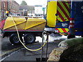
Filling up, Wilton
by Maigheach-gheal for square SU0931 The water board bowser fills from a standpipe that is near the Old Church.
|
|
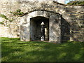
Standpipe, Church Road, Bacton, Herefordshire
by Jaggery geograph for square SO3732 In a stone structure near St Faith's Church.
|
|
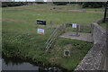
Standpipe, Stoke Bardolph sewage farm
by Alan Murray-Rust geograph for square SK6342 Flexible pipes would be attached to distribute the sewage onto the fields.
Tags:
top:Farm, Fishery, Market GardeningX
type:GeographX
Sewage FarmX
Standpipe
top:Waste, Waste ManagementX
|
|
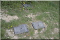
Unmarked water manholes
by Bob Harvey for square TF0819 Valve covers, coded "WO" and "SV" in the verge at the... (more)
Tags:
place:BourneX
type:Close LookX
Control ValveX
top:LowlandsX
subject:ManholeX
Service ValveX
Standpipe
subject:Water InfrastructureX
top:Water ResourcesX
|
|
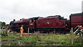
Galatea taking on water
by Bill Harrison geograph for square SD8557 Steam locomotives need a copious supply of water to operate and have to be... (more)
|
|
Village water stanchion
by Bob Harvey geograph for square TF0226 The water standpipe in TF0226 : Village water stanchion has been tidied up since I took that picture,... (more)
Tags:
period:1850sX
Former Village PumpX
type:GeographX
top:LowlandsX
subject:PumpX
Standpipe
top:Village, Rural SettlementX
top:Water ResourcesX
|
|
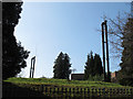
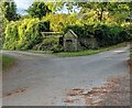
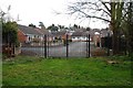
Gates at end of Milldale Close, Kidderminster
by P L Chadwick geograph for square SO8377 Milldale Close is off Lyndhurst Drive, both residential roads. These gates are... (more)
Tags:
GatesX
top:Park and Public GardensX
top:People, EventsX
Public ParkX
Standpipe
top:Suburb, Urban FringeX
War MemorialX
top:Water ResourcesX
|
|
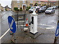
Watering station
by Bob Harvey for square TL0693 Provided for boat dwellers to replenish their tanks. Notices warn that the... (more)
Tags:
type:Cross GridX
place:FotheringhayX
Late SummerX
top:LowlandsX
river:NeneX
weather:OvercastX
top:Rivers, Streams, DrainageX
Scheduled Ancient MonumentX
Standpipe
season:SummerX
subject:Water InfrastructureX
top:Water ResourcesX
|
|
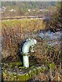
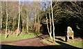
Track into Flakebridge Wood passing water supply pillar
by Roger Templeman geograph for square NY7022 Tags:
Forest TrackX
type:GeographX
top:Roads, Road TransportX
Standpipe
TreesX
top:Water ResourcesX
top:Woodland, ForestX
|
|
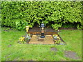
Listed village pump
by Bob Harvey geograph for square SK9924 This is a grade II listed object. See... (more)
Tags:
date:1850X
place:Corby GlenX
Former Village PumpX
type:GeographX
Grade II ListedX
top:LowlandsX
subject:PumpX
Standpipe
top:Village, Rural SettlementX
top:Water ResourcesX
|