Public Tags
Tag: Trunk·Road·(Former)
Showing images tagged with Trunk Road (Former) tag.
|
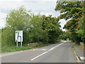
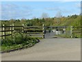
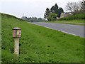
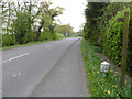
Ermine Street, near Buntingford
by Malc McDonald geograph for square TL3531 This section of Ermine Street, which follows the route of a Roman Road, used to... (more)
Tags:
former:A RoadX
near:BuntingfordX
Former A Classified RoadX
Former Roman RoadX
Former Trunk RoadX
type:GeographX
county:HertfordshireX
subject:RoadX
top:Roads, Road TransportX
Trunk Road (Former)
|
|
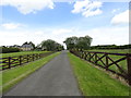
Dorchester Road, Upton
by Malc McDonald geograph for square SY9793 Dorchester Road would once have been a trunk road, taking traffic through the... (more)
Tags:
county:DorsetX
Former Trunk RoadX
type:GeographX
near:PooleX
top:Roads, Road TransportX
Trunk Road (Former)
place:UptonX
subject:VillageX
top:Village, Rural SettlementX
|
|
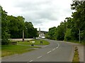
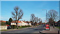
A quiet main road
by Alan Murray-Rust for square NJ3458 The opening of the Fochabers bypass on the A96 Aberdeen and Inverness trunk road... (more)
Tags:
former:A RoadX
type:Cross GridX
top:Roads, Road TransportX
top:Suburb, Urban FringeX
Trunk Road (Former)
|
|
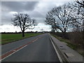
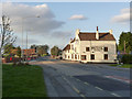
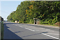
Not a car in sight - Approaching Thorney from the east
by Richard Humphrey geograph for square TF2904 Before the A47 Thorney bypass was built a few years ago this former trunk road... (more)
|
|
Remains of the old A50
by Alan Murray-Rust geograph for square SK1931 Cut off when the current dual carriageway was constructed in the 1980s.
|
|
Rochester Way, Kidbrooke
by Malc McDonald geograph for square TQ4175 Rochester Way used to be the route of the A2 trunk road from Dover, Canterbury... (more)
|
|
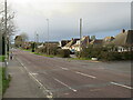
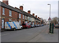
Barleythorpe Road
by Alan Murray-Rust geograph for square SK8509 This relatively narrow street was the trunk A606 prior to the opening of the... (more)
Tags:
top:Roads, Road TransportX
top:Suburb, Urban FringeX
Suburban Main RoadX
housing:TerraceX
Trunk Road (Former)
|
|
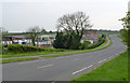
Former A46 at East Stoke
by Alan Murray-Rust geograph for square SK7549 The old Pauncefoote Arms public house became an Indian restaurant which itself... (more)
Tags:
road:A46X
top:Business, Retail, ServicesX
CrossroadsX
former:Public HouseX
subject:RoadX
top:Roads, Road TransportX
Trunk Road (Former)
top:Village, Rural SettlementX
|
|
The old A52 at Mount Pleasant near Risley
by Alan Murray-Rust geograph for square SK4435 The former A52, now the B5010, is much less heavily used than before the opening... (more)
Tags:
road:B5010X
material:Cast IronX
milestoneid:DE DENT07X
period:Early 19th CenturyX
Grade II ListedX
top:Historic Sites and ArtefactsX
Main RoadX
MilepostX
subject:Milepost or MilestoneX
MilestoneX
top:Roads, Road TransportX
Trunk Road (Former)
|
|
Looking up the old road to Kiln Pit Hill
by Robert Graham geograph for square NZ0354 Looking north up the former line of the A68. The new section runs just to the east.
|
|
Coldeast Cross, Liverton
by Alan Hunt geograph for square SX8274 Looking west along the line of the old A38 before the new speedway was built in... (more)
|
|
Golden Valley Farm
by Alan Murray-Rust geograph for square SK4435 Farmstead alongside the old A52. The road, now the B5010, is much less heavily... (more)
Tags:
road:B5010X
top:Farm, Fishery, Market GardeningX
FarmsteadX
Main RoadX
subject:RoadX
top:Roads, Road TransportX
Trunk Road (Former)
|
|
The old A52 near Draycott
by Alan Murray-Rust geograph for square SK4334 Showing one of the original turnpike mileposts... (more)
Tags:
road:B5010X
material:Cast IronX
milestoneid:DE DENT06X
Grade II ListedX
top:Historic Sites and ArtefactsX
Main RoadX
MilepostX
MilestoneX
top:Roads, Road TransportX
Trunk Road (Former)
|