Alkborough - North Lincolnshire
![Creative Commons Licence [Some Rights Reserved]](https://s1.geograph.org.uk/img/somerights20.gif)
Great Britain 1:50 000 Scale Colour Raster Mapping Extracts © Crown copyright Ordnance Survey. All Rights Reserved. Educational licence 100045616.
Contents
Introduction
Preface
This is the third edition (December 2021) of the second of my articles about civil parishes. The photographs are a selection from those on Geograph; there are many more.Geography
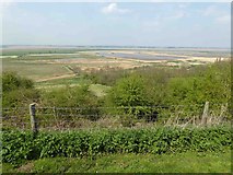
Alkborough village lies on a ridge that has a steep escarpment to the west, down to the River Trent, and a shallow eastern slope down to Halton Drain. The escarpment is formed of Triassic mudstone, and the ridge and land to the east are on shale of the Lower lias in the Jurassic system. This is mainly arable land. The north-western part of the parish is low-lying land adjacent to the River Trent and River Humber. This is alluvium, and was fertile farmland protected by embankments. However on 11 September 2006 the embankment was deliberately breached in order to provide storage for floodwater. The scheme will also provide a new wetland habitat, with seasonal grazing, which is to be designated as a National Nature Reserve.Prehistory
Flint arrowheads and other implements of the Neolithic period (4000BC-2350BC) including a stone axehead have been picked up at Kell Well. An Early Bronze Age (2350BC-1500BC) beaker vessel has been found in the grounds of Walcot Hall. There is evidence for Iron Age and Romano-British settlements within the parish, especially along the top of the escarpment overlooking the River Trent. In 1931, a pot containing a small hoard of Roman coins was dug up just to the south at Walcot Hall. (NLC)History
The names Alkborough and Walcot are Saxon. There is Saxon work in the church, including the tower (Pevsner) and the name 'Walcot' could mean that it was a surviving hamlet of British people (Ekwall). Alkborough and Walcot are listed as separate vills in Domesday Book, but their lands were split between different owners in a complicated way. Ivo Tailbois held land in both vills, but his land in Walcot was leased from Peterborough Abbey. Norman d'Arcy had land in Walcot, which he leased to his man Robert. In Walcot also were two outlying parts of other manors. (Domesday Book)Alkborough is an ancient parish that was in Manley Wapentake, and later in Glanford Brigg Rural District in the Administrative County of Lindsey. In 1974 it became part of the Glanford District of Humberside County, which became, with Scunthorpe District, North Lincolnshire Unitary Authority when Humberside County was abolished in 1996.
The population was 345 in 1801, peaked at 528 in 1841 (Genuki) and was 453 in 2001 (ONS), when there were 188 households of which approximately 140 were in the village.
Much of the agricultural land was in large open fields, cultivated in strips allocated to the villagers, and the older farms are likely to be those fronting the main streets, whilst those out in the fields, such as Southdale Farm, were established after the open fields were enclosed c.1765. The owner of the Walcot estate enclosed his land in the 17C as sheep pasture, which was then more profitable than arable farming. He became wealthy enough to build Walcot Old Hall.
Sources
Maps
Old maps of the area can be seen on the National Library of Scotland website.Modern OS maps can be viewed on the Geograph image pages or on the Streetmap.co.uk website.
Books
Domesday Book - a complete translation, Penguin 2003Fisher= Adrian Fisher & Jeff Saward, The British Maze Guide, 1991
Shell= The Shell and BP guide to Britain,1964
Pevsner= Nicholas Pevsner and John Harris,The Buildings of England - Lincolnshire, Penguin 1964.
Youngs, Frederick A Jr,Guide to the Local Administrative Units of England, Vol II, Royal Historical Society 1991.
Web sites
ONS = Office for National StatisticsNLC = North Lincolnshire Council:
APC = Alkborough Parish Council:
Genuki
historicengland.org.uk The map search gives large-scale mapping with little triangles to indicate listed buildings - click on a triangle to see the listing details.
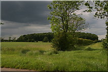
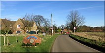
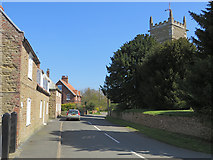
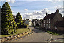
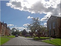
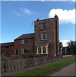
The approach to the village from the south
 Map © Crown Copyright")
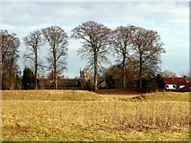
Looking north to Coleby Wood. This was presumably the wood in which the inhabitants of Coleby had commoner's rights. The hamlet of Coleby is in West Halton parish, apart from one of the farm buildings, but it was a vill in Domesday Book so perhaps its territory was later split between West Halton and Alkborough.
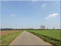
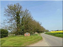
The track gives access to a field and a small wood called Walks End. The field on the right was once allotments. The track is a 'dead-end' right of way.
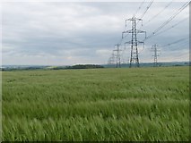
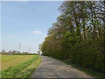
This photograph seems to have been taken from somewhere near the end of the track that leads to Walks End. The pylons march side by side for a long way, before parting company approaching a power station near Immingham.
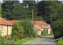
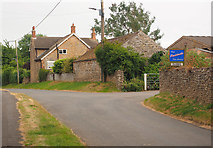
Some of the dwellings at the northern end of this tiny hamlet
by Paul Harrop
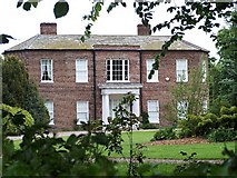
Walcot Hall is a mid-Georgian country house built for Thomas Goulton in 1726, set in 2ha of formal gardens and 9ha of parkland. It has a five-bay front and a big Doric porch, possibly a 19C addition, with an iron balustrade. The outer windows of the front and back of each side are two-storey canted bays. The grounds and gardens round the hall were laid out and planted in 1800. (Pevsner) The Abbey of Peterborough had at one time a chapel, leper hospital and burial ground in Walcot. (NLC).
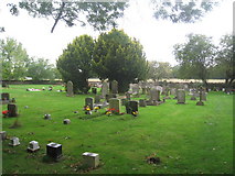
The churchyard had become full, and a new cemetery was made in 1905 on land donated by James Goulton-Constable. In the western corner there is a medieval Christian labyrinth on a metal plaque, on the gravestone of Mr J Goulton-Constable (1850-1922), who ensured that the turf maze was maintained. He was a typical Victorian squire, a driving force behind the building of the present school in 1874 and a generous benefactor to the Cricket Club which played on Westcroft, and to welfare.
The Village
The Church
St John the Baptist's Church was founded in or before 1052, and has a Saxon tower, except for the top stage which was added in the 14C or 15C. The west door is round-headed, in the Saxon style. The belfry was originally in the second stage behind double openings with arched tops, but is now in the third stage with tall double openings of 13C type. The chancel roof has a steeper pitch and higher ridge than that of the nave. The church clock is actually owned by the civil parish. The Parish Council is responsible for ensuring its regular winding and maintenance. The clock was made at the Harrison workshops in Barton and is considered very rare and attracts interest from far and wide (APC).The arch between tower and nave incorporates Roman stones. The nave arcades are of the 12C, but the aisles were rebuilt in the 14C. The south doorway to the nave is in Early English style, highly decorated. The chancel, vestry and porch were added or rebuilt when the church was restored by J.O.Scott in 1887. As you enter the timber porch there is on the floor a copy of the medieval maze made in 1887; it also appears in a stained glass window above the altar (Fisher).
The oak reredos behind the Altar was made by Thompson of Kilburn in the early 1920s. His signature mouse can be seen on the right hand upright (APC).
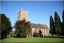
An Anglo-Saxon tower with early English top, Early English nave and chancel by Oldrid Scott in 1887. The churchyard neatly mown and without headstones
by Richard Croft
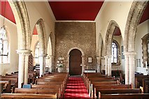
Looking west towards the Anglo-Saxon tower arch
by Richard Croft
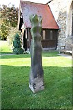
Medieval cross shaft in St.John the Baptist's churchyard, much defaced, seemingly from being used to sharpen agricultural implements
by Richard Croft
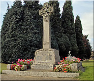
Eleven names from the Great War and five from WWII.
by David Wright
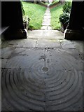
The maze design imitates the geometry of the labyrinthine design of nearby Julian's Bower, overlooking The Trent. The historical significance of it is uncertain.
by Neil Theasby
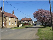
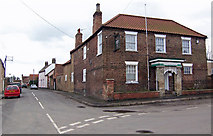
The village streets
The north-western corner of the village, with the Church of St John the Baptist partly visible on the right.
by Paul Harrop
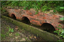
According to Ian Thompson's "Lincolnshire Springs and Wells" the triple brick arches date from about 1850. They provide water to a horse trough for the benefit of the teams returning up the hill from Alkborough Flats below.
They were restored on behalf of the Parish Council in 1986. For photo before restoration see Link
They were restored on behalf of the Parish Council in 1986. For photo before restoration see Link
by Chris
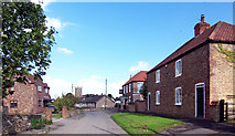
Photo taken in Back Street looking towards the church.
by David Wright
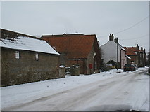
Looking north in the centre of the village
by Paul Harrop
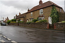
Shows the mixture of brick and stone buildings that can be found in the village.
by Jonathan Thacker
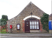
The former Post Office, which closed in 2006
The Wesleyan Methodist chapel on the right is listed, Grade II. It is dated 1840.
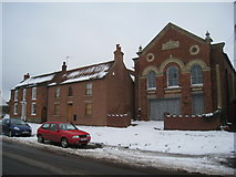
Bethel Primitive Methodist Chapel, established in 1864. The ground floor frontage has been spoilt and the inscription defaced.
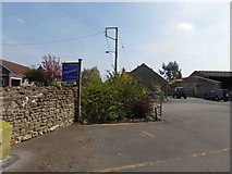
College Farm - Magdalene College, Cambridge, was endowed with a farm in Alkborough in 1624 by Frances Dowager, Countess of Warwick. The college still has the farm (I am assuming that it is College Farm). (APC)
When a pasture field adjacent to Countess Close was ploughed, building debris of limestone, tile, burnt stone and areas of clay floors were uncovered. The pottery finds show that these house sites were occupied from the 13C to the 16C. This area might previously have been the site of a small cell of Benedictine monks founded in 1052 by Spalding Priory; the monks were recalled to Spalding in 1220. (NLC)
Julian's Bower is a circular medieval turf maze, 12m in diameter. It is of a medieval Christian design, with eleven rings (Fisher). It is thought to have been cut around the year 1200 by Benedictine monks who lived locally. The monastic cell was an offshoot of the Monastery at Spalding, and was closed in 1220. It was first recorded in 1697. In 1866 a visitor noted that villagers played May-eve games on the maze (Fisher). It is a scheduled ancient monument, owned by the Parish Council.
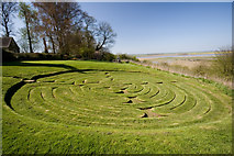
Seen from its northern side, Julian's Bower is turf-cut maze on a hillside overlooking the confluence of the River Ouse and River Trent. No-one knows who originally cut the 12 metre maze (technically a labyrinth - as it has a single entrance and path), or when, but it is first recorded in 1697.
by Paul Harrop
Countess Close moated site, the buried and earthwork remains of a fortified medieval manor house located at the top of the scarp above the River Trent. associated with Countess Lucy, who was countess in her own right ofLeicester, Lincoln and Chester. She married Ivo Taillebois, nephew of William the Conqueror, who was Peterborough Abbey's tenant at Walcott and who was given land in Alkborough by the abbey sometime before his death in 1104. (information from ancientmonuments.uk)
Photo taken in Back Street looking towards the church.
by David Wright
The Coronation Club, the social hub of the village, was established about 70 years ago, so was presumably named after the coronation of George VI. The building is much older than that, of course
Opposite Cross Lane a house called 'The Olde Library' - Mary, Lady Strickland (1797-1865), amongst other charitable works, was responsible for the building of the National and Infants Schools, now Watersmeet, and the Old Library in Back Street (APC).
Great Britain 1:50 000 Scale Colour Raster Mapping Extracts © Crown copyright Ordnance Survey. All Rights Reserved. Educational licence 100045616.
( Page 1 2 3 next >> )