Public Rights of Way in Bournemouth
![Creative Commons Licence [Some Rights Reserved]](https://s1.geograph.org.uk/img/somerights20.gif)
Great Britain 1:50 000 Scale Colour Raster Mapping Extracts © Crown copyright Ordnance Survey. All Rights Reserved. Educational licence 100045616.
Contents
- INTRODUCTION
- Nature of the rights of way
- Research
- Numbering
- Notes on the maps used
- The smartphone experiment
- THE RIGHTS OF WAY
- 'A' series (Westbourne and Talbot Woods wards)
- 'B' series (West Cliff ward)
- 'C' series (Central ward)
- 'D' series (East Cliff ward)
- 'E' series (Kinson ward) - E01 to E20
- 'E' series - E21 to E40
- 'E' series - E41 to E56
- 'F' series (Boscombe West ward)
- 'G' series (Boscombe East ward)
- 'H' series (West Southbourne ward)
- 'I' series (Southbourne ward) - I01 to I11
- 'I' series - I12 to I20
- 'I' series - I21 to I33
- 'J' series (Littledown ward)
- 'K' series (Strouden Park ward) - K01 to K17
- 'K' series - K18 to K26
- 'K' series - K27 to K35
- 'K' series - K36 to K50
- 'L' series (Moordown ward)
- 'M' series (Muscliff ward) - M01 to M14
- 'M' series - M15 to M18
- 'N' series (Winton ward) - N01 to N08
- 'N' series - N09 to N16
- 'N' series - N17 to N42
- 'O' series (Ensbury Park and Redhill Park wards)
- 'U' series (Wallisdown ward) - U01 to U18
- 'U' series - U20 to U43
'G' series (Boscombe East ward)
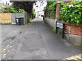
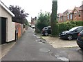
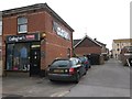
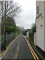
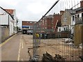
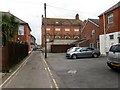
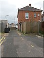
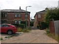
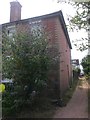
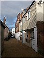
Number: G01
Designation: Public footpath
Length: 82m
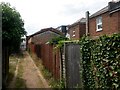
Route: Southbourne Lane West, [SZ 1294 9186] to [SZ 1302 9183]
Map:
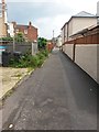
Commentary: Rear access driveway to shops/flats in Southbourne Grove, between Fisherman's Avenue and Chestnut Avenue. Continues eastward as H02.
 (to left)
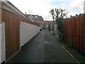
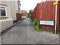
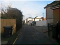
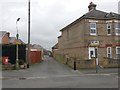
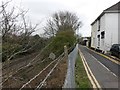
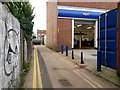
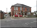
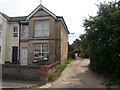
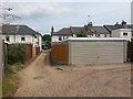
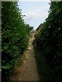
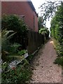
Number: G02
Designation: Public footpath
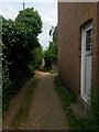
Length: 105m
Route: Broom Lane, [SZ 1300 9174] to [SZ 1298 9184]
Map:
Commentary: Rear access driveway to shops/flats in Fisherman's Avenue, between Pine Avenue and G01.
Seen here heading right from path G01:
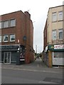
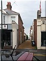
Number: G03
Designation: Public footpath
Length: 55m
Route: Rosebery Road [SZ 1234 9227] to Morley Road [SZ 1239 9230]
Map:
Commentary: Short rear access driveway to odd numbers 881-895 Christchurch Road.
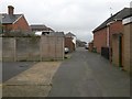
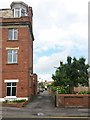
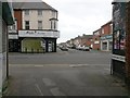
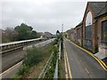
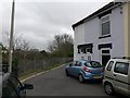
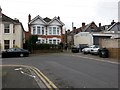
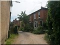
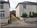
Number: G04
Designation: Public footpath
Length: 267m
Route: Christchurch Road [SZ 1237 9234] to York Place [SZ 1212 9238]
Map:
Commentary: Hannington Place, a driveway mostly running alongside the railway line to the dead end of York Place (forms a short part of York Place at that end).
 (G05 is to left)
 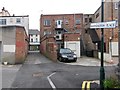 (G05 to right)
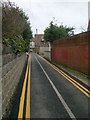
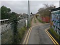
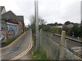
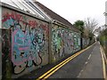
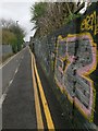
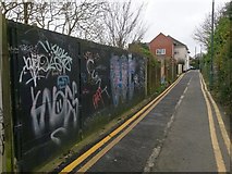
I remember this long driveway when it had a rough gravel surface, probably in the mid 1990s. Because its entire length is motorable, one could cheekily use it as a cut-through if traffic in central Boscombe was heavy. The tarmacking was carried out probably about 15 years ago.
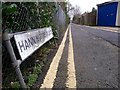
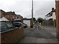
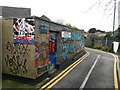
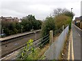
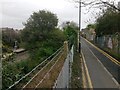
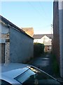
Number: G05
Designation: Public footpath
Length: 34m
Route: Hannington Road [SZ 1232 9234] to G04 [SZ 1235 9236]
Map:
Commentary: Short rear driveway, linking Hannington Place with Hannington Road.
 (path G05 is opposite)
Seen here heading off from path G04 (Hannington Place):
(to left) (to right)Number: G06
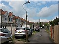
Designation: Public footpath
Length: 187m
Route: Warwick Place, [SZ 1215 9223] to [SZ 1231 9233]
Map:
Commentary: Rear access driveway to even numbers 834-892 Christchurch Road.
Seen here in the background, from path G05 opposite:
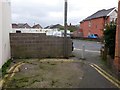
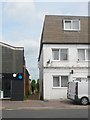
Number: G07
Designation: Public footpath
Length: 18m
Route: Colville Road [SZ 1219 9218] to Colonnade Road [SZ 1217 9217]
Map:
Commentary: Tiny access from sharp bend of Colville Road, including short final stretch of Colonnade Road.
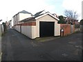
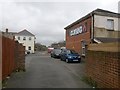
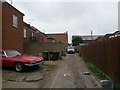
Number: G08
Designation: Public footpath
Length: 78m
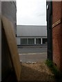
Route: Stourvale Place, [SZ 1264 9236] to [SZ 1270 9234]
Map:
Commentary: Gravel driveway with a few houses on it; right-angled turn midway along.
 (Cromwell Place, footpath G09, heads off to the right)
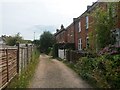
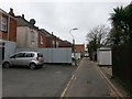
Number: G09
Designation: Public footpath
Length: 103m
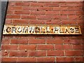
Route: Cromwell Place, [SZ 1256 9229] to [SZ 1264 9235]
Map:
Commentary: Small driveway (barely wide enough for a car) heading through to Stourvale Place (G08) from main road, reducing to a gravel path at the Stourvale end. Has a few houses on it, on an offshoot path coming off at a right-angle.
Seen here (to right) from Stourvale Place:
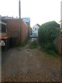
Number: G10
Designation: Public footpath
Length: 53m
Route: Seabourne Road [SZ 1285 9201] to Deans Road [SZ 1288 9205]
Map:
Commentary: Gravel driveway to rear of shops. Path G11 meets it halfway along.
 (path G11 heads left here)
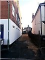
Number: G11
Designation: Public footpath
Length: 26m
Route: Hosker Road [SZ 1285 9205] to G10 [SZ 1287 9203]
Map:
Commentary: Gravel driveway to rear of shops, meeting similar path G10.
Just visible heading left here from path G10:
Great Britain 1:50 000 Scale Colour Raster Mapping Extracts © Crown copyright Ordnance Survey. All Rights Reserved. Educational licence 100045616.
( Page < < prev 1 ... 5 6 7 8 9 10 11 12 13 14 15 16 17 ... next >> )