My geograph apprenticeship on the Shotley peninsula
The first time I visited the Shotley Peninsula was in 2009, where, after a visit to Arger Fen ![]() , I followed (by car) the north side of the Stour to the sea. After a walk along the Stour near Holbrook
, I followed (by car) the north side of the Stour to the sea. After a walk along the Stour near Holbrook ![]() I decided to that this was an area that needed exploring.
I decided to that this was an area that needed exploring.
I was already taking pictures of landscapes, mostly woodland and coast, when I encountered geograph a couple of years before I joined in May 2011. I had a small Sony compact and a nokia phone with a crude map, but it did at least give GPS co-ordinates. For my first geograph project I decided that I would try and take a picture in every grid square in an area north of the Stour, east of the A12 and south of the Orwell (and the A14) ![]() . This is roughly the Shotley peninsula with the addition of Belstead, Bentley and East Bergholt.
. This is roughly the Shotley peninsula with the addition of Belstead, Bentley and East Bergholt.
The attractions of the area, from a geographing point of view, were that many of the squares had fewer than 4 pics and it was within a couple of hours traveling distance from my home in London; I was surprised how relatively undiscovered parts this part of Suffolk is apart from a couple of higher profile tourist areas around East Bergholt ![]() and Pin Mill
and Pin Mill ![]() .
.
After the first month or so of contributing to geograph, where I began to learn about the differences between a "supplemental" ![]() and a "geograph"
and a "geograph" ![]() I invested in a canon G12, and got viewranger Link
I invested in a canon G12, and got viewranger Link![]() software for my phone, which allowed me to record my trips and link co-ordinates with PicLocata Link
software for my phone, which allowed me to record my trips and link co-ordinates with PicLocata Link![]() which was a lot quicker than taking a photo of the co-ordinates from my phone.
which was a lot quicker than taking a photo of the co-ordinates from my phone.
The first area I explored was the walk along the north of the Stour starting from Brantham ![]() , which is the most industrial
, which is the most industrial ![]() part of the area. On route to Shotley via Stutton, Holbrook and Erwarton there are some lovely bays
part of the area. On route to Shotley via Stutton, Holbrook and Erwarton there are some lovely bays ![]() , hardy oaks,
, hardy oaks, ![]() , and saltings
, and saltings ![]() .
.
Shotley Point is where the Stour and Orwell meet ![]() ; and walking north along the Orwell gives good views of Felixstowe Docks
; and walking north along the Orwell gives good views of Felixstowe Docks ![]() and the different craft that ply their trade
and the different craft that ply their trade ![]() . In comparison to the Stour, the Orwell shore seems to attract more people, possibly because of the road link to Ipswich. As you approach Pin Mill there are a number of wrecks on the foreshore
. In comparison to the Stour, the Orwell shore seems to attract more people, possibly because of the road link to Ipswich. As you approach Pin Mill there are a number of wrecks on the foreshore ![]() ,
, ![]() continuing north you will reach the busy area of Pin Mill harbour
continuing north you will reach the busy area of Pin Mill harbour ![]() and the nearby Butt and Oyster pub.
and the nearby Butt and Oyster pub.
Inland the main land use is farming, both arable ![]() and livestock
and livestock ![]() with some evidence of diversification such as business units
with some evidence of diversification such as business units ![]() and farm shops
and farm shops ![]() .
.
There are some areas of woodland including a woodyard ![]() . The woodland walks I particularly enjoyed include Cutlers Wood near Freston
. The woodland walks I particularly enjoyed include Cutlers Wood near Freston ![]() , Holly Wood
, Holly Wood ![]() and Dodnash Wood
and Dodnash Wood ![]() both near Bentley. The walk through Dodnash Wood leads to the Dodnash Priory Stone
both near Bentley. The walk through Dodnash Wood leads to the Dodnash Priory Stone ![]() .
.
Alton Water ![]() is a reservoir created in 1987, and which split the village of Tattingstone in half, linked by Lemons Hill bridge
is a reservoir created in 1987, and which split the village of Tattingstone in half, linked by Lemons Hill bridge ![]() . Alton water has a number of leisure activities, including a cycle path
. Alton water has a number of leisure activities, including a cycle path ![]() which is close to the Tattingstone Wonder
which is close to the Tattingstone Wonder ![]() .
.
I visited the area a number of times between May and September 2011, and managed to find some friendly watering holes. If I had made the journey early in the day up from London I would set myself up with a breakfast at the Harvest Moon Cafe ![]() , just off the A12. I also enjoyed breaks at the Butt and Oyster (mentioned above) The White Horse, Tattingstone
, just off the A12. I also enjoyed breaks at the Butt and Oyster (mentioned above) The White Horse, Tattingstone ![]() ; Case is Altered, Bentley
; Case is Altered, Bentley ![]() and The Kings Head, East Bergholt
and The Kings Head, East Bergholt ![]() .
.
At a certain point in my first few months as a geographer I got addicted to the red dots on the personal map, and so just had to geograph every possible square in the selected area, even if there was just a slither of land. These steps ![]() on the banks of the Orwell were just yards inside the square (helpful having viewranger on my phone). A difficult one to get, possibly because of high tide, was this view
on the banks of the Orwell were just yards inside the square (helpful having viewranger on my phone). A difficult one to get, possibly because of high tide, was this view ![]() of a fallen tree on the banks of the Stour. There is rather more of Stutton Ness
of a fallen tree on the banks of the Stour. There is rather more of Stutton Ness ![]() than appears on the map. I think I was the first person to have both camera and image safely inside the square TM2333 . The square that got away was TM1432 which was always under water when I was by the shore; perhaps I'll keep and eye on tide tables and have my rubber boots handy just to bag this one at some stage in the future.
than appears on the map. I think I was the first person to have both camera and image safely inside the square TM2333 . The square that got away was TM1432 which was always under water when I was by the shore; perhaps I'll keep and eye on tide tables and have my rubber boots handy just to bag this one at some stage in the future.
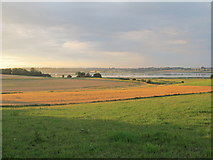
I think the area is well worth a visit; there are still plenty of squares to document with only a handful of pictures . The Orwell shore is perhaps busier than the Stour, so if you are after a solitary walk in characteristic rural Suffolk the area North of the Stour near Harkstead ![]() and Erwarton
and Erwarton ![]() will take some beating; this picture
will take some beating; this picture ![]() was taken walking back from the shore one summer evening after a 4 hour walk, on the way to civilisation and a pint of Adnams.
was taken walking back from the shore one summer evening after a 4 hour walk, on the way to civilisation and a pint of Adnams.
- When
- Fri, 24 Feb 2012 at 09:00
- Chosen Photo
blog comments powered by Disqus