A traverse of the Malvern Hills
For anyone living in the counties of Herefordshire or Worcestershire the line of the Malvern Hills is a familiar sight on the horizon. In fact, the hills form part of the boundary between these two counties, the southern slopes of Chase End Hill, the most southerly of the hills, is in Gloucestershire. The origin of the name Malvern is probably from the ancient British moel-bryn, meaning "Bare-Hill",
The Malvern Hills are formed around 680 million years ago. The hills are the eroded remains of volcanic magma chambers which were created in the southern hemisphere, about 60 degrees south of the equator. Mostly igneous and metamorphic rocks, the hills are late Precambrian and among the hardest and oldest rocks in England.
The hills are popular with walkers and attract people from far and wide. I regularly walk on the hills and as friends were walking the length of the hills from south to north I took the opportunity to join them. Public transport is limited, so we parked cars at Hollybush in the south, and near the clock tower below North Hill at the other end of the hills. Unfortunately, parking at Hollybush means missing the two most southerly hills, Chase End and Ragged Stone Hill. There is no parking available at the very south and including these two hills would mean walking south from Hollybush and then backtracking to the car park before continuing north. This diversion adding about another 4 miles to the walk.
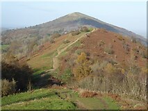
Leaving the car park and heading north, the first ascent was Midsummer Hill, the path is rather steep, albeit not too lengthy though and the path soon emerges just below the summit of the hill. On the summit there is what appears to be a bus shelter. It looks a little incongruent, though it offers fine views to the east and Im sure on occasion offers welcome shelter. Inside a plaque commemorates Captain Reginald Somers Cocks M.C. who gave Midsummer Hill and its iron age hill fort to the National Trust in 1923.
The Somers family lived at Eastnor Castle which can be seen to the west, along with the obelisk in the parkland which celebrate illustrious family members. The path descends and passes through Gullet Wood and then follows the ridge of Swinyard Hill before crossing the broad Hangmans Hill leading to Broad Down. Here the Shire Ditch, also known as the Red Earls Dyke becomes a prominent feature, it is an earthwork following most of the spine of the hills. It was thought this dyke running along the length of the Malvern Hills was created at the orders of Gilbert de Clare, the Red Earl in the late 13th century to mark the boundary between his land and that of the Bishop of Hereford. It is now believed to be much earlier.
A short zig-zag path with steps ascends Millennium Hill and then it is an easy walk to the Herefordshire Beacon. This hill is better known as the British Camp, a large Iron Age hillfort dating from the 2nd century BCE. The diarist John Evelyn remarked that the view from this hill was "one of the godliest vistas in England". The descent from here is steep in places and is partly via concrete steps which have been there as look as I can remember. The path emerges on to a large car park beside the A449, here there is the Malvern Hills Hotel, or if you prefer, a small café where we stopped for a coffee.
The Jubilee Drive which was constructed to celebrate one of Queen Victorias jubilees joins the A449 here. We follow this road for a few metres before following a path on the right which took us past the rear of Wynds Point, a house which was home of Swedish opera singer Jenny Lind in the 19th century. Here the path returns to the ridge and easily ascends Black Hill and then it is a bit of a roller coaster over Pinnacle Hill, Jubilee Hill and Perseverance Hill until we reach Upper Wyche where a road passes through a cutting in the hills. The origin of the name Wyche may be as a result of it being an ancient salt road. Droitwich, a source of salt is not many miles away, to the north of Worcester. The Wyche Inn is just round the corner and is a great place to stop for a pub lunch. The pub enjoys fine views to the east over the Severn vale to the Cotswold Hills.
After lunch it is a gentle walk following a broad tarmac path leading all the way to the too of the Worcestershire Beacon. The path used to provide access for deliveries to a café which used to be situated just below the summit. It burned down in the early 1970s and was never replaced. There is a small levelled area to the west of the summit where it once stood. On the rocky top of the Worcestershire Beacon, there is a trig point and just to the north there is also a toposcope which was placed here in 1897 to celebrate Queen Victorias Diamond Jubilee. At 425m (1395ft), the Worcestershire Beacon is the highest point in the Malvern Hills. To the east there is nothing this high as far as the Ural Mountains, and in the winter with a cold east wind it feels like it. To the west some twenty-five miles away on the border between England and Wales the Black Mountain rise to just over 700m.
After the Worcestershire Beacon the is a steady descent, leaving just three more hills, Sugarloaf Hill, Table Hill and finally North Hill. Reaching North Hill there is an abrupt end to the hills with the land falling away steeply to the north. From the top of North Hill there are excellent views over Herefordshire and Worcestershire. To the north are the Abberley Hills, to the north-east there are the Clent Hills and Lickey Hills, hiding the large urban conurbation of Birmingham and the west midlands. To the north-west the Shropshire hills of Titterstone Clee Hill, Brown Clee Hill and the Wrekin, near Telford are all clearly visible on a day with clear visibility.
We dropped down to the Lady Howard De Walden Drive, a path with contours North Hill and then we followed a zig-zag path to the car park near the clock tower at North Malvern. The Malvern Hills are about 9 miles long from north to south, on our walk we had walked about 10 miles in total.
You can see this trip plotted on a map on the Geo-trips page Link .
- When
- Fri, 26 Nov 2021 at 15:38
- Grid Square
 SO7641
- Chosen Photo
blog comments powered by Disqus