The Taking of Beyond the Point
Following on from The Taking of the Last of the Machars on the 8th May 2011 it became clear that additional land had been sighted (land ahoy!) on the improved mapping now used by Geograph resulting in two new additional grid squares being added to NX33 Link.
NX3539 Link and NX3638 Link to outward appearances look to be all at sea however closer inspection of OS 1:25000 mapping and satellite imagery shows that both squares do appear to have a smidgen of land on them, maybe only a footprint, but there is land there somewhere.
Both the grid squares are off the Point of Lag near Monreith and after a recce visit it became obvious that the only way to get into (and out of!) the grids was to wait until around the time of a full moon when the tide was at its lowest to have the best chance of taking pictures without using a waterproof camera, canoe or wet suit.
So .... off I trotted on the 20th May 2011 to bash the NX33 hectad Link for the second and hopefully final time. The first low tide of the day was at 8.30am which was the time I arrived to start the challenge.
Beyond the Point of Lag - Front Bay 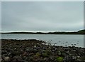 in NX3539 Link
This spur of land is north of the Point of Lag and west of Front Bay at Monreith and it can only be accessed at low tide for a few hours. Getting here to bag this first took ½ hour to cross 500 yards of slippery rocks and seaweed. It was a truly treacherous journey akin to walking on moving ice.
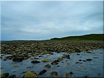
Beyond the Point of Lag - Back Bay 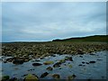 in NX3638 Link
This area of land is south of the Point of Lag in Back Bay at Monreith and like Front Bay can only be accessed at low tide for a few hours. Getting to this grid took over ½ hour to cross 600 yards of rocks, seaweed and rock pools. It was a really difficult journey moving across the slippery terrain like a drunken spider to bag this first. The only way to get pictures in the grid square was to balance on one of the last rocks still above the tide.
So all being well as they say, bagging these two newly discovered grid squares means that NX33 Link and The Machars Link![]() Link
Link![]() is bashed at last.
is bashed at last.
Onwards and upwards to the bogs and hills for the next green 'un!
- When
- Sat, 21 May 2011 at 12:12
- Grid Square
 NX3638
- Chosen Photo
blog comments powered by Disqus