2008
NS3778 : A lichen - Pertusaria corallina
taken 15 years ago, near to Renton, West Dunbartonshire, Scotland
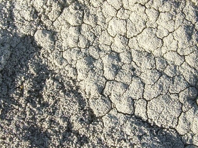
A lichen - Pertusaria corallina
This lichen is "very common on exposed siliceous rocks in upland and coastal areas, rarely on bark" [F.S.Dobson, "Lichens - An Illustrated Guide to the British and Irish Species"].
That description fits the situation of this specimen, which was growing in an exposed sunlit position on one of the stones of a dry-stone wall (that section of wall is shown here: NS3778 : Dry-stone wall).
The surface of the lichen is "areolate"; in other words, it is divided up like crazy paving into smaller areas that are called areoles. Through a hand-lens, these areas can be seen to be made up of tiny rod-like structures that are branched like coral (hence the species name). These rod-like structures are called isidia; they contain fungal and algal cells, the two components that make up a lichen. Broken-off isidia can therefore develop asexually into new lichens.
In this photograph, the isidia are most clearly seen in the bottom-left corner, where they appear to be most developed.
(For some very different-looking species in the same genus, see: NS3882 : A lichen - Pertusaria amara and NS3883 : A lichen - Pertusaria pertusa.)
 Map © Crown Copyright")
TIP: Click the map for more Large scale mapping
- Grid Square
- NS3778, 210 images (more nearby 🔍)
- Photographer
- Lairich Rig (more nearby)
- Date Taken
- Tuesday, 18 November, 2008 (more nearby)
- Submitted
- Tuesday, 18 November, 2008
- Subject Location
-
OSGB36:
 NS 3780 7848 [10m precision]
WGS84: 55:58.3099N 4:36.0387W - Camera Location
-
OSGB36: NS 3780 7848
- View Direction
- Northwest (about 315 degrees)