NU2328 : Lime kiln, Beadnell Bay
taken 20 years ago, near to Beadnell, Northumberland, England
Beadnell is a village in Northumberland. It is situated south-east of Bamburgh, on the North Sea coast.
It has the only west-facing port on the east coast of England, Beadnell is a tourist base, the village consisting largely of holiday homes, with some small-scale fishing. Two large caravan sites neighbour the village, as well as a handful of campsites.
The parish church of St Ebba was built in 1746 and restored in the nineteenth century. A sixteenth-century pele tower remains as part of the public house, The Craster Arms.
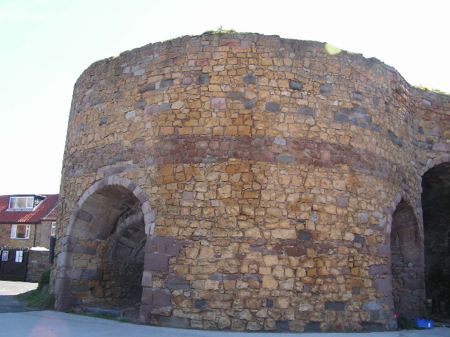
Near the harbour are historic limekilns, now owned by the National Trust. Beadnell is within the North Northumberland Heritage Coast and the Northumberland Coast Area of Outstanding Natural Beauty.
For Wikipedia entry for Lime Kilns see Link
Three lime kilns, the earliest built in 1789, are located to the east of Beadnell Harbour. By 1822 the kiln had fallen out of use and was used for curing herring. Limestone was burnt in limekilns to make lime, which was used to improve the quality of soil. Lime from these kilns was sent to Scotland from the nearby harbour. They are now used by local fishermen to store lobster pots. They are Grade II Listed Buildings. Link

 Map © Crown Copyright")
- Grid Square
- NU2328, 355 images (more nearby 🔍)
- Photographer
- N Chadwick (more nearby)
- Date Taken
- Wednesday, 2 June, 2004 (more nearby)
- Submitted
- Sunday, 22 January, 2006
- Subject Location
-
OSGB36:
 NU 237 286 [100m precision]
WGS84: 55:33.0318N 1:37.5548W