2009
TG1425 : To Aylsham on the Marriott's Way
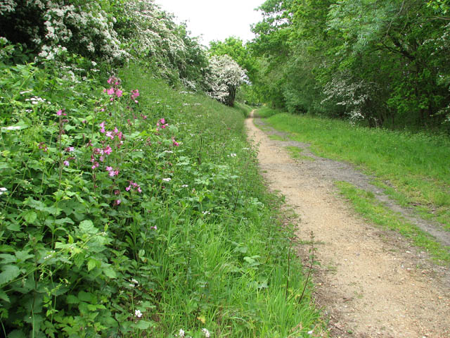
taken 15 years ago, near to Southgate, Norfolk, England
To Aylsham on the Marriott's Way
The flowers of the red campion > Link form a pleasant contrast to the green grass and the white flowers of the cow parsley. Red campion (Silene dioica) can be found growing abundant on rich soils at the edges of woods or in hedgerows. Its name is derived from Silenus, the god of the woodlands in Greek mythology and the second part of its scientific name, dioica, means 'two houses', and refers to the fact that each Red Campion plant has flowers of one sex only, so that two plants are needed to make seed. Female flowers have no stamens, while male flowers have only a small, non-functioning ovary.
This section of the Marriott's Way leads from Chapel Street - by the former goods yard > Link at Cawston railway station > Link - to the hamlet of Southgate > Link further to the northeast and onwards to Aylsham > Link.
What now forms part of the Marriott's Way once used to be a railway line which ran from County School via Themelthorpe > Link to Aylsham > Link and Wroxham - built by the Great Eastern Railway and completed in 1883, and from Themelthorpe to Norwich > Link - built in 1882 by the Midland and Great Northern Joint Railway (M&GN). The so-called Themelthorpe Curve was added later in order to link the two stretches of railway - opened in 1960, this section was the final section of railway track built in Norfolk by British Rail. The line was not profitable and closed in 1985. The dismantled railway trackbed is now a long-distance footpath, named after William Marriott, the chief engineer and manager of the M&GN railway system for 41 years. He was based and lived in the village of Melton Constable > Link the then main depot of the M&GN railway. Link
 Map © Crown Copyright")
TIP: Click the map for more Large scale mapping
- Grid Square
- TG1425, 21 images (more nearby 🔍)
- Photographer
- Evelyn Simak (more nearby)
- Date Taken
- Saturday, 23 May, 2009 (more nearby)
- Submitted
- Sunday, 24 May, 2009
- Subject Location
-
OSGB36:
 TG 149 254 [100m precision]
WGS84: 52:47.0221N 1:11.1827E - Camera Location
-
OSGB36: TG 149 254
- View Direction
- East-northeast (about 67 degrees)