2005
NS3974 : Dumbarton Rock: the French Prison
taken 19 years ago, near to Dumbarton, West Dunbartonshire, Scotland
This is 1 of 2 images, with title Dumbarton Rock: the French Prison in this square
Dumbarton Rock: the French Prison
[This is one of a linked series of articles about Dumbarton Rock. See the end of Link for a list of the reference works that are cited here in abbreviated form.]
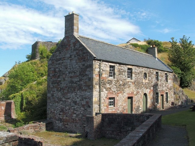
The French Prison, shown in the foreground, was built in about in 1790, but acquired its present name about 20 years later, when it held prisoners from the Napoleonic Wars [OSG07, p5, 25].
This building stands on the northern side of a level area between the Rock's two peaks. The eastern peak, the Beak, is visible in the background. On its top, the upper part of the Magazine is visible directly behind the French Prison. To the upper left, the bastion of the Duke of Argyll's Battery is visible.
On the near side of the French Prison, there formerly stood several buildings that defended the important north entrance of the medieval castle; these buildings included the Wallace Tower (see the next item in this series).
Previous: NS3974 : Dumbarton Rock: the Portcullis Arch.
Next: NS3974 : Dumbarton Rock: the Wallace Tower.
Dumbarton Rock and Castle :: NS4074
The Rock is a volcanic plug, and it has a long history as a fortified site. For further information, see the Geograph article "Dumbarton Rock and Castle": Link
 Map © Crown Copyright")
TIP: Click the map for more Large scale mapping
- Grid Square
- NS3974, 267 images (more nearby 🔍)
- Photographer
- Lairich Rig (more nearby)
- Date Taken
- Monday, 8 August, 2005 (more nearby)
- Submitted
- Thursday, 2 July, 2009
- Subject Location
-
OSGB36:
 NS 3996 7453 [10m precision]
WGS84: 55:56.2262N 4:33.8236W - Camera Location
-
OSGB36: NS 3995 7453
- View Direction
- East-southeast (about 112 degrees)