2008
SJ3384 : The Leverhulme Memorial at Port Sunlight
taken 16 years ago, near to Port Sunlight, Wirral, England
This is 1 of 12 images, with title The Leverhulme Memorial at Port Sunlight in this square
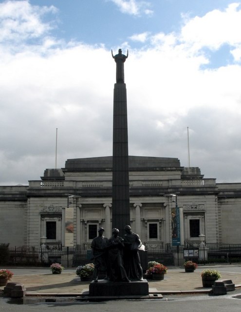
The Leverhulme Memorial at Port Sunlight
Port Sunlight is a model village and 'Conservation Area' on the Wirral Peninsula between Lower Bebington and New Ferry. Construction began in 1888; today the village comprises 900 Grade II listed buildings.
Named after the popular brand of "Sunlight Soap", Port Sunlight was built by William Hesketh Lever (1851-1925) - later Lord Leverhulme - for the employees of Lever Brothers soap factory (now part of Unilever). Lever personally helped to plan the village and employed nearly thirty different architects in its design. Between 1899 and 1914, 800 houses with a population of 3,500 were built, together with allotments and public buildings, including the Lady Lever Art Gallery, a cottage hospital, schools, a concert hall, open air swimming pool, church, and a temperance hotel. Lever also introduced schemes for welfare, education and the entertainment of his workers, and encouraged recreation and organisations which promoted art, literature, science or music.
The Leverhulme Memorial (Sir William Reid Dick, R.A., 1930) is in Queen Mary's Drive, adjacent to the Lady Lever Art Gallery. The Memorial is a pylon in black granite surmounted by a figure of 'Inspiration' with a group in green bronze at the foot representing Industry, Education, Charity, and Art, the four great interests in Lord Leverhulme's life. The group took Reid Dick 3 years to complete. Upwards of 22,000 employees of Messrs Lever Brothers contributed to its construction.
 Map © Crown Copyright")
TIP: Click the map for more Large scale mapping
- Grid Square
- SJ3384, 399 images (more nearby 🔍)
- Photographer
- Gerald Massey (more nearby)
- Date Taken
- Friday, 1 August, 2008 (more nearby)
- Submitted
- Tuesday, 15 September, 2009
- Subject Location
-
OSGB36:
 SJ 335 847 [100m precision]
WGS84: 53:21.3424N 2:59.9900W - Camera Location
-
OSGB36: SJ 335 847
- View Direction
- East-northeast (about 67 degrees)