2009
TM4997 : Somerleyton Hall
taken 15 years ago, near to Herringfleet, Suffolk, England
This is 1 of 9 images, with title Somerleyton Hall in this square
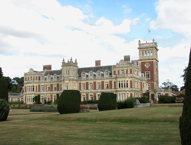
Somerleyton Hall
The first stone manor house on the site was built in about 1240 by Sir Peter Fitzosbert. He was succeeded by the Jernegan family who lived at Somerleyton for 13 generations. The tomb chest of Sir Richard Jernegan > Link - Privy Councellor to Henry VIII - is the oldest feature in St Mary's church > Link which is located in the grounds, a short distance to the south. In 1610 the house was rebuilt in the East Anglian Tudor-Jacobean style by John Wentworth, also commemorated in St Mary's church > Link. Sir John was captured and jailed during the English Civil War (but later freed by Cromwell's troops) and one of his captors, Sir Thomas Allin, bought the estate in 1672. Sir Morton Peto acquired the estate in 1843 and had it changed to the Italian-Victorian house we see today > Link. Sir Peto also had St Mary's church repaired and refurbished. A new model village > Link was built to the design of John Thomas, the architect of Somerleyton Hall, and the railway > Link was brought to the village in 1847. Sir Francis Crossley bought the Hall from Peto in 1863. In 1916 Sir Savile Crossley became Baron Somerleyton and his son, the 3rd Baron, inherited the title in 1959. Charles Dickens - a friend of Morton Peto - visited in 1848 while researching and writing 'David Copperfield' which is set in nearby Blundeston. Sir Christopher Cockerell, inventor of the Hovercraft, tested his first model on the Pergola Lawn of the Hall.
 Map © Crown Copyright")
TIP: Click the map for more Large scale mapping
- Grid Square
- TM4997, 112 images (more nearby 🔍)
- Photographer
- Evelyn Simak (more nearby)
- Date Taken
- Thursday, 24 September, 2009 (more nearby)
- Submitted
- Friday, 25 September, 2009
- Subject Location
-
OSGB36:
 TM 492 977 [100m precision]
WGS84: 52:31.2346N 1:40.3462E - Camera Location
-
OSGB36: TM 491 977
- View Direction
- Northeast (about 45 degrees)