2009
SK1616 : Wychnor Park Country Club
taken 14 years ago, near to Orgreave, Staffordshire, England
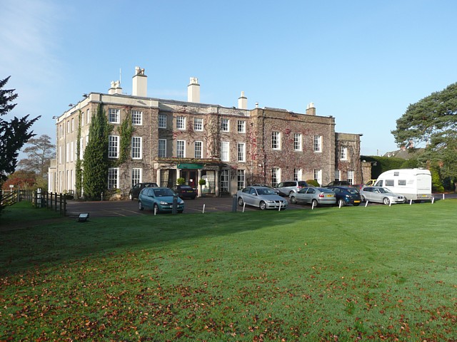
Wychnor Park Country Club
In 1554 work started on the first house on this site, which replaced the medieval manor house near the church. I was built by the Griffiths family, who held the manor from 1355 to 1661, when debts incurred due to fighting for the King during the Civil War forced the sale to Lady Offley. Her son Crew built the present hall c.1760 after the Tudor hall was destroyed by fire. John Levett bought the estate in 1765, and the Levett family sold it to Cnl. Harrison in 1913. The long eastern front looks as if there has been a large extension to the right in the late 18C or early 19C. In 1976 the estate was broken up, and the hall was owned by The Mercers, farmers, until 1981 when it was sold and turned into a Country Club. This was not a financial success, and was sold to L.S.I. in 1996, and became a time-share resort. It is now owned by Diamond Resorts. There are apartments in the house, with usual bar and restaurant, and in modern buildings in the garden behind the house. There are also 'log cabins', actually comfortable bungalows with exterior wood cladding, with views over the Trent Valley, a leisure centre and a golf course. Ghost investigators claim that the hall is haunted. (Based on an information sheet produced by Diamond Resorts).
 Map © Crown Copyright")
TIP: Click the map for more Large scale mapping
- Grid Square
- SK1616, 25 images (more nearby 🔍)
- Photographer
- Humphrey Bolton (more nearby)
- Date Taken
- Thursday, 12 November, 2009 (more nearby)
- Submitted
- Monday, 16 November, 2009
- Subject Location
-
OSGB36:
 SK 162 167 [100m precision]
WGS84: 52:44.8608N 1:45.6870W - Camera Location
-
OSGB36: SK 162 167
- View Direction
- WEST (about 270 degrees)