TG2407 : Trowse railway station
taken 14 years ago, near to Trowse Newton, Norfolk, England
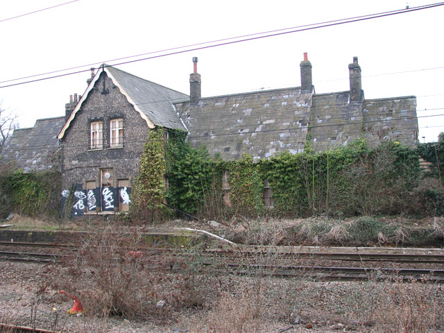
With the extension of the Eastern Counties Railway Company's London line from Brandon to Norwich (opened in 1845) they created the first direct line to London. Until the opening of Trowse swing bridge in December of the same year all trains stopped at Trowse station (a Grade II listed building). However, a rival company - the Eastern Union Company - began the construction of an additional line from Norwich to Ipswich which was a faster and more direct route to London which resulted in the Eastern Counties Union being very reluctant to allow access to their station, hence forcing the rival company to build their own (in Victoria Street). In 1851 a loop was constructed between Trowse upper and lower junctions. The Eastern Counties Company eventually took over the Eastern Union Company (in 1854) and both companies were incorporated into the Great Eastern Railway in 1862. Due to its position at the junction of the two lines Trowse became an important marshalling yard, and goods heading towards Norwich Cattlemarket came through here. Extensive sidings and warehouses as well as cattle and sheep pens were built alongside the tracks. The sidings remained in place until electrification in the 1980s and aggregate is still being delivered to one siding today. The station closed to passenger traffic in 1939 but was reopened for a few weekends when Thorpe depot closed and the tracks around Thorpe station were realigned and new signalling installed as part of the electrification programme in the 1980s. The central platform, semaphore signals and signal boxes were removed in 1987.
The settlement of Trowse Millgate originated at the bridging point over the River Yare, the ideal location for a mill. The character of the area underwent significant changes in the 19th century when the railway and the sewage works were built. With the onset of post war decline, the character changed again but by the late 20th century this decline was beginning to be reversed with the construction of new housing and the restoration of historic buildings.
Trowse Millgate was first designated a conservation area on 2 January 1979 and extended a couple of years later to include the former railway station and the former Pineapple public house to the north of the railway line. The area lies within the floodplain of the River Yare one mile to the south east of Norwich city centre and covers an area of 3.9 hectares.
 Map © Crown Copyright")
- Grid Square
- TG2407, 545 images (more nearby 🔍)
- Photographer
- Evelyn Simak (more nearby)
- Date Taken
- Thursday, 21 January, 2010 (more nearby)
- Submitted
- Friday, 22 January, 2010
- Subject Location
-
OSGB36:
 TG 244 072 [100m precision]
WGS84: 52:37.0024N 1:18.8230E - Camera Location
-
OSGB36: TG 244 072
- View Direction
- West-southwest (about 247 degrees)