TG4803 : Gt Yarmouth to St Olaves railway - Belton
taken 14 years ago, near to Burgh Castle, Norfolk, England
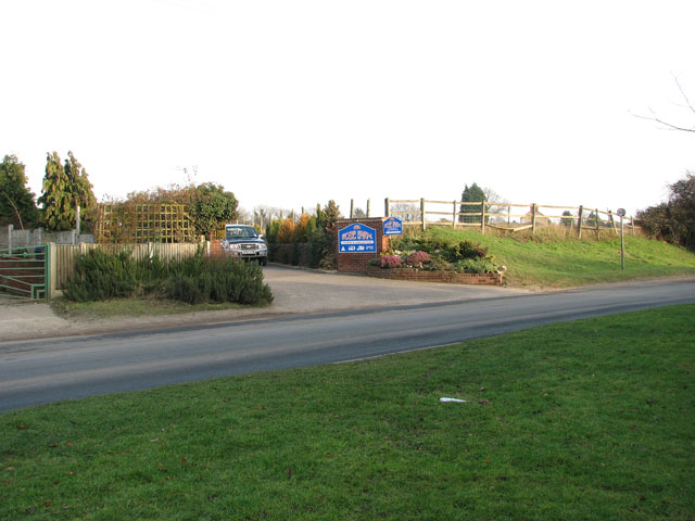
the unusual name of which dates from the times before drainage pipes were laid here and when the road had to be crossed via stepping stones in a ford. The grassed-over area in the foreground marks the location where a railway bridge once took the Gt Yarmouth to St Olaves line over the road. See also > Link. The railway used to run along the lane seen on the other side which not provides access to the Rose Farm camping and caravan site.
The line connected Gt Yarmouth (South Town) and St Olaves (Haddiscoe High Level), from where it curved into Fritton Woods. Running in north-easterly direction it entered the village of Belton. No trace of Belton & Burgh Castle station remains: the location and some of the surrounding countryside was designated for development and residential housing now covers much of this area. Running north-west from Belton to Bradwell the line passed All Saints church > Link in the north west, crossing St Johns Road and Shortsteps via a bridge, passing Burgh Castle in the south-west. Entering Bradwell from the south-west the line ran alongside Doles Lane. Before reaching Yarmouth South Town station the railway was crossed by the old Lowestoft to Yarmouth line (closed 1970).
A railway station at Haddiscoe was first opened by the Norfolk Railway in 1847 at the Herringfleet Junction. In 1854 the Halesworth, Beccles and Haddiscoe Railway (later renamed the East Suffolk Railway Co.) was opened between those towns and extended via Darsham to Ipswich in 1859. The original Haddiscoe station was closed by the Great Eastern Railway in 1904 in favour of the current location at the junction of the Wherry Line > Link - Link and the now closed Yarmouth-Beccles Line from London to Yarmouth. Both stations operated until withdrawal of services on the Yarmouth line in 1959 which resulted in the closure of the Haddiscoe high level station > Link. Until closure the two stations were linked - the link being controlled by the Haddiscoe Junction signal box. The East Suffolk line crossed the then Great Eastern line via a (since dismantled) bridge > Link just south of Haddiscoe high level station.
 Map © Crown Copyright")
- Grid Square
- TG4803, 102 images (more nearby 🔍)
- Photographer
- Evelyn Simak (more nearby)
- Date Taken
- Tuesday, 26 January, 2010 (more nearby)
- Submitted
- Wednesday, 27 January, 2010
- Subject Location
-
OSGB36:
 TG 487 033 [100m precision]
WGS84: 52:34.2353N 1:40.1719E - Camera Location
-
OSGB36: TG 487 032
- View Direction
- East-northeast (about 67 degrees)