NS4274 : Ruins of Mattockhill
taken 14 years ago, near to Milton, West Dunbartonshire, Scotland
The remnants of an enclosure associated with Mattockhill can be seen in the field just south of the ruins: NS4274 : Remains of enclosure at ruins of Mattockhill.
In connection with the old name High Chapelton, compare NS4275 : Possible site of Old Chapel of Colquhoun; a Canmore entry, linked from there, quotes from the same work, where reference is made to a "Chapel Knowe"; the knoll shown in that photograph is located only 150 metres to the north of the Mattockhill ruins.
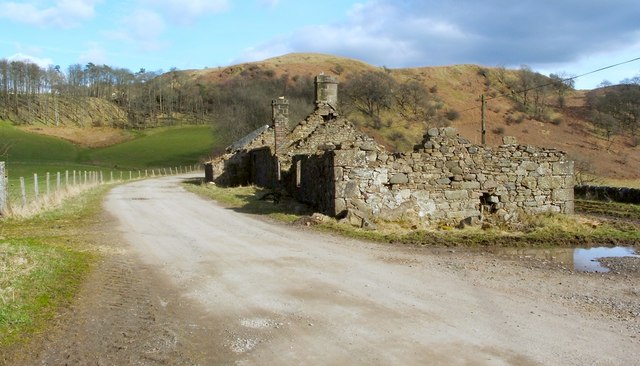
There are two buildings here, almost end to end; there was a space between them, which was walled on one side, and roofed over (see NS4274 : Ruins of Mattockhill). Whether or not it had a door where there is now a gap, it was probably used for storage.
The farther of the two buildings has a feature that the nearer does not: a small annexe, which can be seen in the present picture projecting from the left-hand side of the far end of the buildings. It was not present in 1896, but was added before the First World War.
The site is marked, as Chappeltouns, on the Blaeu Map of the Lennox (published in 1654, but based on earlier surveys), and as Marrockhill on Ainslie's 1821 "Map of the Southern Part of Scotland". The relevant OS Name Book, compiled in 1860, observes that the name Mattockhill was the one given by the tenant, by the factor, and in the Valuation Rolls; it records the alternative names High Chapelton, from an estate plan, and Chapelton, from a county map, but observes that those names were no longer in use. The Farm Horse Tax Rolls for 179798 have an entry for "Robert Paul, Chappel". That this is the same place is made clear by John Bruce's 1893 book "History of the Parish of West or Old Kilpatrick", which states that Robert Paul was the tenant farmer of Mattockhill in 1796, and that he was one of five local men who were chosen, on the 17th of July of that year, to serve as church elders for West Kilpatrick Parish.
 Map © Crown Copyright")
- Grid Square
- NS4274, 129 images (more nearby 🔍)
- Photographer
- Lairich Rig (more nearby)
- Date Taken
- Friday, 2 April, 2010 (more nearby)
- Submitted
- Wednesday, 7 April, 2010
- Subject Location
-
OSGB36:
 NS 4291 7495 [10m precision]
WGS84: 55:56.5108N 4:31.0077W - Camera Location
-
OSGB36: NS 4288 7495
- View Direction
- EAST (about 90 degrees)