2010
NS4375 : Riggangower
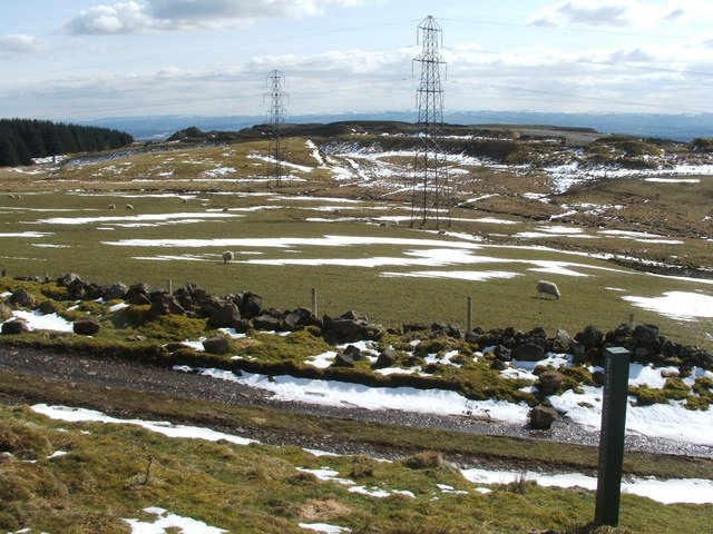
taken 14 years ago, near to Milton, West Dunbartonshire, Scotland
This is 1 of 2 images, with title Riggangower in this square
Riggangower
The path in the foreground is the same one as is shown in NS4375 : The Crags Circular Path - leaving the forest (the same green-painted post appears in both photos).
The raised area behind the pylons is, according to signs in the area, Riggangower Quarry Landfill Site; see NS4375 : Riggangower pylons. The spelling of the place-name varies considerably between maps; at the time of writing, OS maps show "Rigangower", but I've used the more common spelling in this description.
According to entries in the parish register of births, as cited by John Bruce in his 1893 "History of the Parish of West or Old Kilpatrick", older spellings included Riddingower(*) and Riddengower(*) (from entries dated 1749 and 1754, respectively).
[(*) An additional remark of my own on these early forms: compare the element found in the nearby place-name "Barundridain" (shown on the 1654 Blaeu map of the Lennox), presumably related to the later "Roundredding/Rindredding" that is currently commemorated in the name of NS4075 : Round Riding Road.]
The same work notes, in a later chapter, that "on the hill near Greenland farm a few huts called Riggangower formerly stood, but no trace of them now remains. The name, however, is still shown on the Ordnance Survey map. It is said that the houses were removed when Greenland farm was laid out."
Further details are provided in Donald MacLeod's slightly earlier book "The Clyde District of Dumbartonshire" (1886); Bruce's account of this event clearly draws heavily on MacLeod's (as usual, he does not credit him, though).
MacLeod mentions that the removal of the houses and the eviction of their occupants caused resentment in the district, and that a local poetess composed some verses on the subject. By MacLeod's time, only three verses of that ballad were still remembered in the district. MacLeod gives the text of those verses; the first two of them describe the pleasure that people used to take in this area. In contrast, the last verse says:
"But the moudiewort wild elf cam' up,
An' yirded in the knowe;
And gart the biggins a' fa' doun,
That were in Riggangow."
["moudiewort": literally, "a mole" (the animal), but here = "sly, underhanded";
"knowe": knoll; "yirded in": bashed into the ground;
"biggins": buildings; "gart": made, caused to.]
It is not clear just when Greenland Farm was laid out, but there is a gravestone in the NS4673 : Kirkyard of Old Kilpatrick Parish Church for a Walter Scott in Greenland, who died in 1858.
The OS Object Name Book (1890s), which provides authority for the names shown on the map, shows that some people considered Connelton to be an alternative name for Greenland, but not all agreed with this. The ONB entry says: "Greenland a good homestead on Auchentorlie Estate, the property of R Buchanan Esq. Connelton is never used with the name Greenland, the factor would not adopt it here, nor the two names to Mattockhill which see."
Donald MacLeod, on page 43 of his book cited above, says that "Connalton was situated very near to where the present Auchentorlie Hill stands, but it stood more on the brow of the hill overlooking Dunglass". On Mattockhill and its alternative name (as alluded to above), see NS4274 : Ruins of Mattockhill.
For a later view, similar to the present picture, but less wintry, see NS4375 : Riggangower.
 Map © Crown Copyright")
TIP: Click the map for more Large scale mapping
- Grid Square
- NS4375, 60 images (more nearby 🔍)
- Photographer
- Lairich Rig (more nearby)
- Date Taken
- Friday, 2 April, 2010 (more nearby)
- Submitted
- Saturday, 10 April, 2010
- Subject Location
-
OSGB36:
 NS 4387 7523 [10m precision]
WGS84: 55:56.6803N 4:30.0962W - Camera Location
-
OSGB36: NS 4383 7557
- View Direction
- SOUTH (about 180 degrees)