2010
NZ2362 : Shelduck and the Dunston Coal Staiths
taken 14 years ago, near to Dunston, Gateshead, England
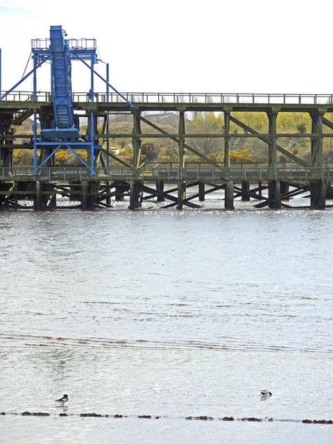
Shelduck and the Dunston Coal Staiths
STAITHES - (pronounced 'steeths') is the Geordie dialect word for a pier used for loading coal onto ships Link
Dunston Coal Staithes (sometimes spelt, 'Staiths') is one of the major industrial landmarks on the River Tyne.
At 1,709ft long and 50ft wide, it is reputed to be the largest timber structure in Northern Europe.
Commissioned by the North Eastern Railway Company and opened in 1893, it was built as part of the Dunston Extension Railway to export coal from Tyneside and County Durham collieries.
At its peak in the 1920s, the staithes shipped an average of 140,000 tons of coal per week.
Dunston eventually became the last working staithes on the River Tyne, closing in 1980. The site was renovated in 1987-88 using timber salvaged from the now demolished South Staithes so that it could be used as part of the National Garden Festival in 1990.
The staithes is a listed building and a scheduled monument. It was put on the English Heritage 'At Risk Register' due to the serious fire damage which took place in November 2003, when a section of the structure was lost. Another blaze in July, 2010, damaged the upper rail deck.
The area around the staithes is also an important habitat for wildlife including two designated Local Wildlife Sites: saltmarsh and mudflats, home to an important wading bird population.
Link
See other images of Dunston Coal Staithes
 Map © Crown Copyright")
TIP: Click the map for more Large scale mapping
- Grid Square
- NZ2362, 219 images (more nearby 🔍)
- Photographer
- Andrew Curtis (more nearby)
- Date Taken
- Thursday, 22 April, 2010 (more nearby)
- Submitted
- Saturday, 24 April, 2010
- Subject Location
-
OSGB36:
 NZ 2345 6266 [10m precision]
WGS84: 54:57.4819N 1:38.1202W - Camera Location
-
OSGB36: NZ 2342 6290
- View Direction
- SOUTH (about 180 degrees)