TG4704 : Roman Tiles
taken 14 years ago, near to Burgh Castle, Norfolk, England
The Norfolk Archaeological Trust (NAT) owns this impressive Roman fort at the village of Burgh Castle, near Great Yarmouth. The preserved walls of the fort are in the care of English Heritage, but the NAT owns the fort itself, most of the surrounding farmland and an adjacent area of reed beds. The property in all covers 90 acres (37 hectares), the fort itself containing 6 acres.
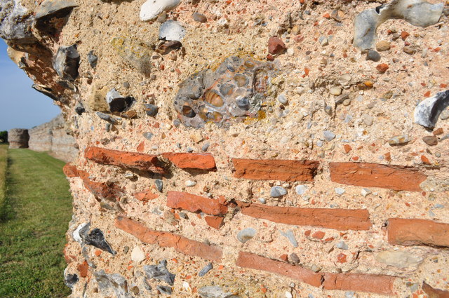
Burgh Castle was built in the late third or early fourth centuries after AD260. Being part of a string of forts around the south and east coasts stretching from Portchester to Brancaster in north Norfolk. This example is one of the best preserved, 7 miles to the north Caistor on Sea also has some surviving parts. The fort now overlooks a large expanse of grazing marshes to the west which once formed a great inland estuary, the west wall has been eroded by the river over the years. The forts were built to protect from attacks from Saxons visiting from Northern Germany. The walls were 4 metres high, built of flint and tiles. Finished with knapped flint. Evidence suggests outside support buildings and agriculture. It housed a fast acting elite Greek cavalry unit.
By the early fifth century Roman authority was crumbling. Whether due to internal or external pressures, people began abandoning Roman towns and fortresses throughout Britain.
Later, when the Normans came they built a castle in the south west corner, although little of that remains after it was levelled in the eighteenth century.
 Map © Crown Copyright")
- Grid Square
- TG4704, 232 images (more nearby 🔍)
- Photographer
- Ashley Dace (more nearby)
- Date Taken
- Tuesday, 6 July, 2010 (more nearby)
- Submitted
- Wednesday, 7 July, 2010
- Subject Location
-
OSGB36:
 TG 474 045 [100m precision]
WGS84: 52:34.9378N 1:39.0966E - Camera Location
-
OSGB36: TG 475 045
- View Direction
- WEST (about 270 degrees)