2010
TM4679 : The church of SS Peter and Paul in Wangford - C17 pulpit
taken 14 years ago, near to Wangford, Suffolk, England
The church of SS Peter and Paul in Wangford - C17 pulpit
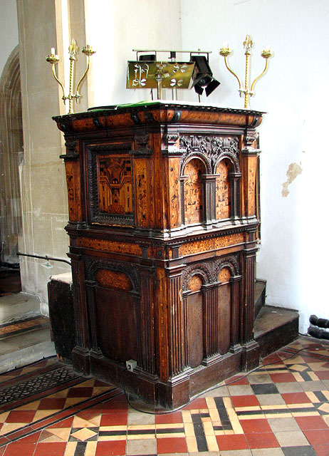
The church of SS Peter and Paul > Link was built on the site of on an older, Norman church. However, after several restorations nothing remains from Norman times and only the nave, north aisle and porch are medieval. The church once formed part of the priory church of a Cluniac monastery and at the same time served as the parish church. After its suppression all monastery buildings and parts of the church were demolished. The removal of the last monastic remains was completed in 1862 and the well-known architect Edward Lushington Blackburne was commissioned to restore the church. The old box pews were replaced by new benches, and a new tower was built not at the west end, as is usual, but at the east end of the north aisle. In fact, the church is believed to never have had a west tower. A new chancel and vestry were completed in 1875. The church retains the original C15 baptismal font > Link and a C17 pulpit and reading desk > Link with rich carving and wood inlay, which is thought to be of Flemish influence. The stained glass windows date from the Victorian restoration. The east window > Link is by Heaton, Butler and Payne and the west window > Link was made by Gibbs and Howard in 1887.
 Map © Crown Copyright")
TIP: Click the map for more Large scale mapping
- Grid Square
- TM4679, 146 images (more nearby 🔍)
- Photographer
- Evelyn Simak (more nearby)
- Date Taken
- Tuesday, 21 September, 2010 (more nearby)
- Submitted
- Wednesday, 22 September, 2010
- Subject Location
-
OSGB36:
 TM 465 791 [100m precision]
WGS84: 52:21.2942N 1:37.1845E - Camera Location
-
OSGB36: TM 465 791
- View Direction
- EAST (about 90 degrees)