TM5177 : Too close for comfort #2
taken 13 years ago, near to Southwold, Suffolk, England
In the 19th century, a variety of groynes and breakwaters were constructed in an attempt to protect Southwold's shoreline. In 1899-90 timber breastwork was constructed on two levels as protection for the town, and a major new project was undertaken in 1903 to create sea defences. The work has continued ever since with the construction of concrete promenades > Link which stemmed the erosion to the coastal border of the town. The groynes > Link were renewed in 1980. In 2005 a major new sea defence programme was begun by the Environment Agency in conjunction with Waveney District Council which involved the building of a completely new set of timber groynes in front of the town and huge rock groynes to the north of the pier. The beach was afterwards recharged with new sand to replace that which had been scoured away. Despite all efforts, high tides and gale force winds sometimes still drive the sea over the promenade, and the groynes are sinking into the sand.
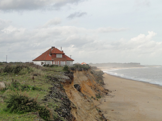
The defence works stop just short of Easton Bavents > Link where building is not allowed and no protection will occur. This will eventually result in the loss of (what is left of) the village of Easton Bavents, and surrounding farmland. House owners decided to take matters into their own hands. Since 2002 one of them has used more than a quarter of a million tons of clay, shingle and building site waste to shore up the cliff > Link - Link in an effort to protect his property from being washed into the sea. When Natural England in 2005 designated the cliff a site of special scientific interest (SSSI), preventing residents from further work, an appeal was made and eventually won so that the work could continue, provided planning permission for the construction of private defences were granted. However, despite all efforts the two houses immediately concerned > Link are at present only metres away from the cliff edge, and plans are now underway to raise money to pay for the demolition costs.
Easton Bavents, once sheltered by Sole Bay, used to be the most easterly point of Britain, until erosion took much of it away and Lowestoft became the most easterly location. Once a prosperous community with a market, a fair and churches, the church of St Nicholas as well as most of the houses of the village had been lost to the sea by the 17th century. Sole Bay once used to be a real bay - set between the twin promontories of Easton Bavents and Dunwich to the south - before erosion, exacerbated by a prevailing south-westerly wind, reshaped the whole coastline. The village just to the north of Easton Bavents, Covehithe, lost 17 metres of coastline in one year in the 1990s. The erosion of the sand cliffs at Easton > Link continues, and there is fear that one day the sea will break through and sweep in towards the town of Southwold, coming over the marshes from the north. The B1127 road is already notorious for being flooded quite regularly a short distance further to the north, by Potters Bar > Link .
Since 2005 this section of coastline forms part of the Pakefield to Easton Bavents SSSI which is nationally important for its assemblage of scarce vascular plants and species of breeding birds including a wintering population of bittern (Botaurus stellaris). There are also a number of features of special interest such as the coastal geomorphology at Benacre Ness, the Pleistocene vertebrate palaeontology and Pleistocene / Quaternary of East Anglia at Easton Bavents > Link as well as vegetated shingle, saline lagoons > Link and flood-plain fens. A by-product of the coastal erosion in the area are the many finds of fossils that have been discovered over the years. Deposits of amber and jet as well as petrified wood have also been uncovered, and in 2006 erosion revealed the remains of what is believed to be 17th century salt pans.
 Map © Crown Copyright")
- Grid Square
- TM5177, 56 images (more nearby 🔍)
- Photographer
- Adrian S Pye (more nearby)
- Date Taken
- Wednesday, 27 October, 2010 (more nearby)
- Submitted
- Wednesday, 27 October, 2010
- Subject Location
-
OSGB36:
 TM 512 775 [100m precision]
WGS84: 52:20.3091N 1:41.2160E - Camera Location
-
OSGB36: TM 512 774
- View Direction
- North-northeast (about 22 degrees)